|
| Mesoscale Discussion 571 |
|
< Previous MD Next MD >
|
|
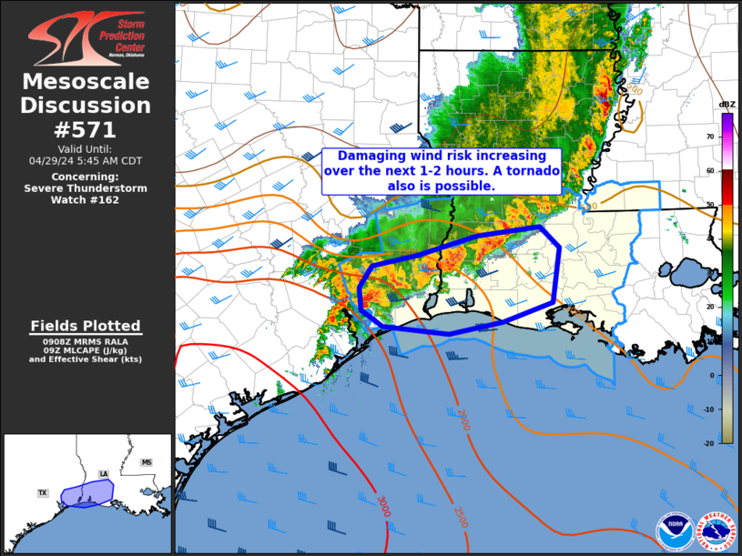
   Mesoscale Discussion 0571
   NWS Storm Prediction Center Norman OK
   0411 AM CDT Mon Apr 29 2024

   Areas affected...far southeast TX into southwest LA

   Concerning...Severe Thunderstorm Watch 162...

   Valid 290911Z - 291045Z

   The severe weather threat for Severe Thunderstorm Watch 162
   continues.

   SUMMARY...The damaging wind risk will increase across far southeast
   Texas into southwest Louisiana over the next 1-2 hours. A tornado
   also may be possible with this activity.

   DISCUSSION...Some increase in intensity has been noted in radar
   imagery over southeast TX into southwest LA in the last 30 minutes
   or so. Reflectivity cores have deepened/intensified on 7 km CAPPI
   and some increase in velocity signatures are also noted. Convection
   will continue to move into an uncapped airmass close to the coast
   characterized by SBCAPE around 1500 J/kg. Furthermore, increasing
   low-level rotation has been noted in cells over southeast TX ahead
   of the convective line. Tornado potential may be somewhat increased
   as these more cellular elements merge with the line in the near
   term. HGX and LCH VWP data show favorable low-level hodographs
   supporting rotation and a brief tornado or two may occur in addition
   to damaging gusts associated with the southeastward surging bow into
   southwest LA.

   ..Leitman.. 04/29/2024

   ...Please see www.spc.noaa.gov for graphic product...

   ATTN...WFO...LCH...HGX...

   LAT...LON   30339468 30479402 30719319 30819228 30559200 29889211
               29639282 29489358 29589452 29779484 30059487 30339468
|
|
Top/All Mesoscale Discussions/Forecast Products/Home
|
|


 @NWSSPC