 Note:
The expiration time in the watch graphic is amended if the watch is
replaced, cancelled or extended.
Note:
Note:
The expiration time in the watch graphic is amended if the watch is
replaced, cancelled or extended.
Note: Click for
Watch Status Reports.
SEL7
URGENT - IMMEDIATE BROADCAST REQUESTED
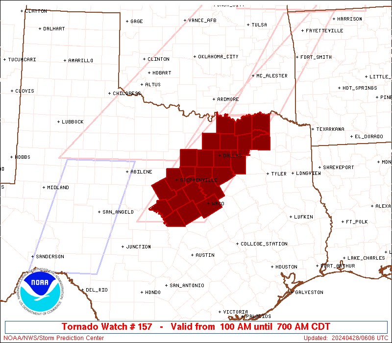
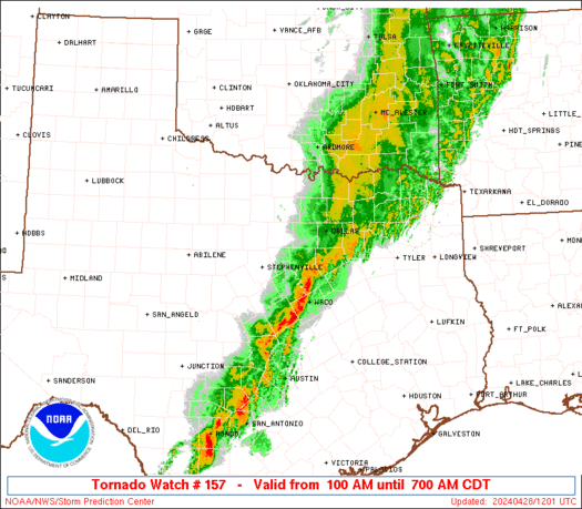
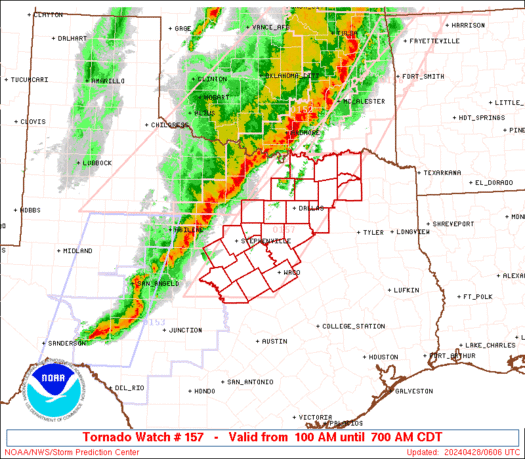
Tornado Watch Number 157
NWS Storm Prediction Center Norman OK
100 AM CDT Sun Apr 28 2024
The NWS Storm Prediction Center has issued a
* Tornado Watch for portions of
North and central Texas
* Effective this Sunday morning from 100 AM until 700 AM CDT.
* Primary threats include...
A couple tornadoes possible
Scattered damaging wind gusts to 70 mph likely
Scattered large hail events to 1 inch in diameter possible
SUMMARY...A squall line will continue to move eastward through the
early morning hours with the potential to produce occasional
damaging winds of 60-70 mph and isolated large hail to 1 inch
diameter. A couple of tornadoes may also occur with embedded
circulations, or with isolated cells merging into the line.
The tornado watch area is approximately along and 60 statute miles
east and west of a line from 30 miles east northeast of Sherman TX
to 55 miles west of Temple TX. For a complete depiction of the watch
see the associated watch outline update (WOUS64 KWNS WOU7).
PRECAUTIONARY/PREPAREDNESS ACTIONS...
REMEMBER...A Tornado Watch means conditions are favorable for
tornadoes and severe thunderstorms in and close to the watch
area. Persons in these areas should be on the lookout for
threatening weather conditions and listen for later statements
and possible warnings.
&&
OTHER WATCH INFORMATION...CONTINUE...WW 152...WW 153...WW
154...WW 155...WW 156...
AVIATION...Tornadoes and a few severe thunderstorms with hail
surface and aloft to 1 inch. Extreme turbulence and surface wind
gusts to 60 knots. A few cumulonimbi with maximum tops to 550. Mean
storm motion vector 27035.
...Thompson
   SEL7

   URGENT - IMMEDIATE BROADCAST REQUESTED
   Tornado Watch Number 157
   NWS Storm Prediction Center Norman OK
   100 AM CDT Sun Apr 28 2024

   The NWS Storm Prediction Center has issued a

   * Tornado Watch for portions of
     North and central Texas

   * Effective this Sunday morning from 100 AM until 700 AM CDT.

   * Primary threats include...
     A couple tornadoes possible
     Scattered damaging wind gusts to 70 mph likely
     Scattered large hail events to 1 inch in diameter possible

   SUMMARY...A squall line will continue to move eastward through the
   early morning hours with the potential to produce occasional
   damaging winds of 60-70 mph and isolated large hail to 1 inch
   diameter.  A couple of tornadoes may also occur with embedded
   circulations, or with isolated cells merging into the line.

   The tornado watch area is approximately along and 60 statute miles
   east and west of a line from 30 miles east northeast of Sherman TX
   to 55 miles west of Temple TX. For a complete depiction of the watch
   see the associated watch outline update (WOUS64 KWNS WOU7).

   PRECAUTIONARY/PREPAREDNESS ACTIONS...

   REMEMBER...A Tornado Watch means conditions are favorable for
   tornadoes and severe thunderstorms in and close to the watch
   area. Persons in these areas should be on the lookout for
   threatening weather conditions and listen for later statements
   and possible warnings.

   &&

   OTHER WATCH INFORMATION...CONTINUE...WW 152...WW 153...WW
   154...WW 155...WW 156...

   AVIATION...Tornadoes and a few severe thunderstorms with hail
   surface and aloft to 1 inch. Extreme turbulence and surface wind
   gusts to 60 knots. A few cumulonimbi with maximum tops to 550. Mean
   storm motion vector 27035.

   ...Thompson
 Note:
The Aviation Watch (SAW) product is an approximation to the watch area.
The actual watch is depicted by the shaded areas.
Note:
The Aviation Watch (SAW) product is an approximation to the watch area.
The actual watch is depicted by the shaded areas.
   SAW7
   WW 157 TORNADO TX 280600Z - 281200Z
   AXIS..60 STATUTE MILES EAST AND WEST OF LINE..
   30ENE GYI/SHERMAN TX/ - 55W TPL/TEMPLE TX/
   ..AVIATION COORDS.. 50NM E/W /53ESE ADM - 63NW CWK/
   HAIL SURFACE AND ALOFT..1 INCH. WIND GUSTS..60 KNOTS.
   MAX TOPS TO 550. MEAN STORM MOTION VECTOR 27035.

   LAT...LON 33889514 31149734 31149936 33889723

   THIS IS AN APPROXIMATION TO THE WATCH AREA.  FOR A
   COMPLETE DEPICTION OF THE WATCH SEE WOUS64 KWNS
   FOR WOU7.
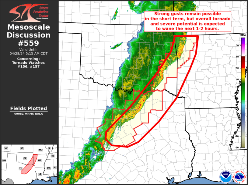
Watch 157 Status Report Messages:
STATUS REPORT #1 ON WW 157

VALID 280725Z - 280840Z

THE SEVERE WEATHER THREAT CONTINUES ACROSS THE ENTIRE WATCH AREA.

..LEITMAN..04/28/24

ATTN...WFO...FWD...

&&

STATUS REPORT FOR WT 157

SEVERE WEATHER THREAT CONTINUES FOR THE FOLLOWING AREAS

TXC035-085-093-099-113-119-121-139-143-147-181-193-217-221-223-
231-251-257-277-281-309-333-367-397-425-439-280840-

TX
.    TEXAS COUNTIES INCLUDED ARE

BOSQUE		     COLLIN		 COMANCHE
CORYELL 	     DALLAS		 DELTA
DENTON		     ELLIS		 ERATH
FANNIN		     GRAYSON		 HAMILTON
HILL		     HOOD		 HOPKINS
HUNT		     JOHNSON		 KAUFMAN
LAMAR		     LAMPASAS		 MCLENNAN
MILLS		     PARKER		 ROCKWALL
SOMERVELL	     TARRANT
$$


THE WATCH STATUS MESSAGE IS FOR GUIDANCE PURPOSES ONLY.  PLEASE
REFER TO WATCH COUNTY NOTIFICATION STATEMENTS FOR OFFICIAL
INFORMATION ON COUNTIES...INDEPENDENT CITIES AND MARINE ZONES
CLEARED FROM SEVERE THUNDERSTORM AND TORNADO WATCHES.
$$
Note:
Click for Complete Product Text.
Tornadoes
Probability of 2 or more tornadoes
|
Mod (40%)
|
Probability of 1 or more strong (EF2-EF5) tornadoes
|
Low (20%)
|
Wind
Probability of 10 or more severe wind events
|
Mod (60%)
|
Probability of 1 or more wind events > 65 knots
|
Low (10%)
|
Hail
Probability of 10 or more severe hail events
|
Mod (40%)
|
Probability of 1 or more hailstones > 2 inches
|
Low (10%)
|
Combined Severe Hail/Wind
Probability of 6 or more combined severe hail/wind events
|
High (90%)
|
For each watch, probabilities for particular events inside the watch
(listed above in each table) are determined by the issuing forecaster.
The "Low" category contains probability values ranging from less than 2%
to 20% (EF2-EF5 tornadoes), less than 5% to 20% (all other probabilities),
"Moderate" from 30% to 60%, and "High" from 70% to greater than 95%.
High values are bolded and lighter in color to provide awareness of
an increased threat for a particular event.


 @NWSSPC