 Note:
The expiration time in the watch graphic is amended if the watch is
replaced, cancelled or extended.
Note:
Note:
The expiration time in the watch graphic is amended if the watch is
replaced, cancelled or extended.
Note: Click for
Watch Status Reports.
SEL4
URGENT - IMMEDIATE BROADCAST REQUESTED
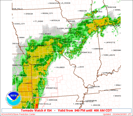
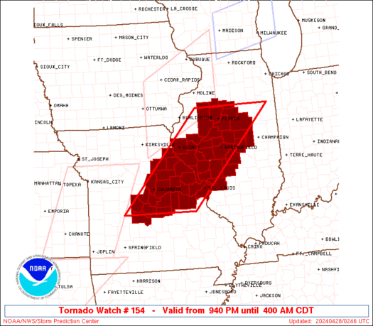
Tornado Watch Number 154
NWS Storm Prediction Center Norman OK
940 PM CDT Sat Apr 27 2024
The NWS Storm Prediction Center has issued a
* Tornado Watch for portions of
Central and Western Illinois
Central and Eastern Missouri
* Effective this Saturday night and Sunday morning from 940 PM
until 400 AM CDT.
* Primary threats include...
A couple tornadoes possible
Scattered damaging wind gusts to 70 mph likely
Scattered large hail events to 1.5 inches in diameter possible
SUMMARY...An severe squall line will move from west to east across
much of the Watch area during the late evening into the overnight.
A few storms may also develop ahead of the line and also pose a
severe risk. Tornadoes and damaging gusts will be the primary
severe hazards.
The tornado watch area is approximately along and 70 statute miles
east and west of a line from 35 miles northeast of Peoria IL to 15
miles west of Vichy MO. For a complete depiction of the watch see
the associated watch outline update (WOUS64 KWNS WOU4).
PRECAUTIONARY/PREPAREDNESS ACTIONS...
REMEMBER...A Tornado Watch means conditions are favorable for
tornadoes and severe thunderstorms in and close to the watch
area. Persons in these areas should be on the lookout for
threatening weather conditions and listen for later statements
and possible warnings.
&&
OTHER WATCH INFORMATION...CONTINUE...WW 149...WW 150...WW
151...WW 152...WW 153...
AVIATION...Tornadoes and a few severe thunderstorms with hail
surface and aloft to 1.5 inches. Extreme turbulence and surface wind
gusts to 60 knots. A few cumulonimbi with maximum tops to 500. Mean
storm motion vector 24035.
...Smith
 Note:
The Aviation Watch (SAW) product is an approximation to the watch area.
The actual watch is depicted by the shaded areas.
Note:
The Aviation Watch (SAW) product is an approximation to the watch area.
The actual watch is depicted by the shaded areas.
   SAW4
   WW 154 TORNADO IL MO 280240Z - 280900Z
   AXIS..70 STATUTE MILES EAST AND WEST OF LINE..
   35NE PIA/PEORIA IL/ - 15W VIH/VICHY MO/
   ..AVIATION COORDS.. 60NM E/W /19ESE BDF - 42S COU/
   HAIL SURFACE AND ALOFT..1.5 INCHES. WIND GUSTS..60 KNOTS.
   MAX TOPS TO 500. MEAN STORM MOTION VECTOR 24035.

   LAT...LON 41028786 38129076 38129333 41029055

   THIS IS AN APPROXIMATION TO THE WATCH AREA.  FOR A
   COMPLETE DEPICTION OF THE WATCH SEE WOUS64 KWNS
   FOR WOU4.
Watch 154 Status Report Messages:
STATUS REPORT #1 ON WW 154

VALID 280545Z - 280640Z

SEVERE WEATHER THREAT CONTINUES RIGHT OF A LINE FROM 25 W COU TO
10 NNE COU TO 25 SSW UIN TO 25 E UIN TO 35 W PIA TO 25 SW MMO.

..LEITMAN..04/28/24

ATTN...WFO...LSX...ILX...SGF...

&&

STATUS REPORT FOR WT 154

SEVERE WEATHER THREAT CONTINUES FOR THE FOLLOWING AREAS

ILC009-013-017-021-039-057-061-083-107-113-115-117-119-125-129-
135-137-147-149-167-169-171-179-280640-

IL
.    ILLINOIS COUNTIES INCLUDED ARE

BROWN		     CALHOUN		 CASS
CHRISTIAN	     DE WITT		 FULTON
GREENE		     JERSEY		 LOGAN
MCLEAN		     MACON		 MACOUPIN
MADISON 	     MASON		 MENARD
MONTGOMERY	     MORGAN		 PIATT
PIKE		     SANGAMON		 SCHUYLER
SCOTT		     TAZEWELL
$$


MOC007-027-029-051-071-073-113-125-131-135-139-141-151-163-173-
183-189-219-510-280640-

MO
.    MISSOURI COUNTIES INCLUDED ARE

AUDRAIN 	     CALLAWAY		 CAMDEN
COLE		     FRANKLIN		 GASCONADE
LINCOLN 	     MARIES		 MILLER
MONITEAU	     MONTGOMERY 	 MORGAN
OSAGE		     PIKE		 RALLS
ST. CHARLES	     ST. LOUIS		 WARREN


MISSOURI INDEPENDENT CITIES INCLUDED ARE

ST. LOUIS CITY
$$


THE WATCH STATUS MESSAGE IS FOR GUIDANCE PURPOSES ONLY.  PLEASE
REFER TO WATCH COUNTY NOTIFICATION STATEMENTS FOR OFFICIAL
INFORMATION ON COUNTIES...INDEPENDENT CITIES AND MARINE ZONES
CLEARED FROM SEVERE THUNDERSTORM AND TORNADO WATCHES.
$$
Note:
Click for Complete Product Text.
Tornadoes
Probability of 2 or more tornadoes
|
Mod (40%)
|
Probability of 1 or more strong (EF2-EF5) tornadoes
|
Low (20%)
|
Wind
Probability of 10 or more severe wind events
|
Mod (60%)
|
Probability of 1 or more wind events > 65 knots
|
Low (20%)
|
Hail
Probability of 10 or more severe hail events
|
Mod (40%)
|
Probability of 1 or more hailstones > 2 inches
|
Low (20%)
|
Combined Severe Hail/Wind
Probability of 6 or more combined severe hail/wind events
|
High (90%)
|
For each watch, probabilities for particular events inside the watch
(listed above in each table) are determined by the issuing forecaster.
The "Low" category contains probability values ranging from less than 2%
to 20% (EF2-EF5 tornadoes), less than 5% to 20% (all other probabilities),
"Moderate" from 30% to 60%, and "High" from 70% to greater than 95%.
High values are bolded and lighter in color to provide awareness of
an increased threat for a particular event.


 @NWSSPC


