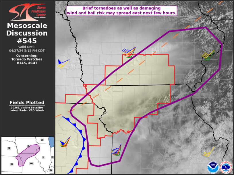
   Mesoscale Discussion 0545
   NWS Storm Prediction Center Norman OK
   0340 PM CDT Sat Apr 27 2024

   Areas affected...eastern Kansas into northern Missouri and southern
   Iowa

   Concerning...Tornado Watch 145...147...

   Valid 272040Z - 272215Z

   The severe weather threat for Tornado Watch 145, 147 continues.

   SUMMARY...The threat for brief tornadoes as well as damaging outflow
   winds and hail continues within the watch areas, and may spread
   east, necessitating additional watch areas.

   DISCUSSION...Supercells formed along a retreating boundary/warm
   front which now extends from northeast KS and northwest MO, and from
   southwest IA into southern WI. Low-level shear is maximized near
   this boundary with 0-1 SRH near 150 m2/s2 and weaker values into the
   open warm sector.

   Heating continues along the boundary, and the 18Z DVN sounding shows
   ample instability and lapse rates to sustain strong to severe
   storms, with generally unidirectional shear profiles. However, only
   minimal low-level hodograph augmentation may be necessary for a
   tornado risk with any supercells that move across northern MO/IA
   through the afternoon. As such, the threat may eventually extend
   beyond WW 147, and another watch and/or extension may become
   necessary depending on trends.

   Farther south into eastern KS and western MO, outflow from initial
   activity extends from northeast KS into north-central OK, while an
   unstable air mass remains just to the east. MLCAPE over 2500 J/kg as
   well as ample deep-layer shear will support supercells and or
   damaging bows this evening, with all modes of severe possible.

   ..Jewell.. 04/27/2024

   ...Please see www.spc.noaa.gov for graphic product...

   ATTN...WFO...ILX...LSX...DVN...DMX...EAX...OAX...TOP...

   LAT...LON   39769312 39559354 39019394 38299431 38129512 38169538
               38419551 38809553 39339566 39619617 39739625 39879618
               40969460 42199236 42309089 41789025 41039038 40319140
               39769312
|


 @NWSSPC