 Note:
The expiration time in the watch graphic is amended if the watch is
replaced, cancelled or extended.
Note:
Note:
The expiration time in the watch graphic is amended if the watch is
replaced, cancelled or extended.
Note: Click for
Watch Status Reports.
SEL2
URGENT - IMMEDIATE BROADCAST REQUESTED
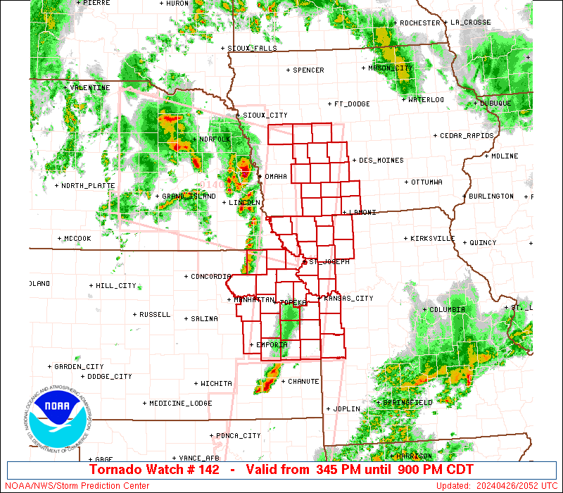
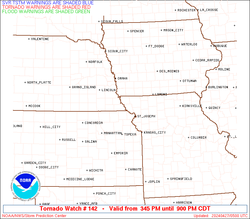
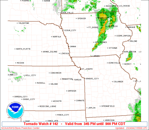
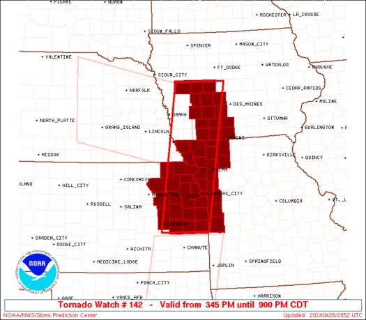
Tornado Watch Number 142
NWS Storm Prediction Center Norman OK
345 PM CDT Fri Apr 26 2024
The NWS Storm Prediction Center has issued a
* Tornado Watch for portions of
Southwest Iowa
Eastern Kansas
Northwest Missouri
* Effective this Friday afternoon and evening from 345 PM until
900 PM CDT.
* Primary threats include...
A few tornadoes likely with a couple intense tornadoes possible
Scattered large hail and isolated very large hail events to 2.5
inches in diameter likely
Scattered damaging wind gusts to 70 mph likely
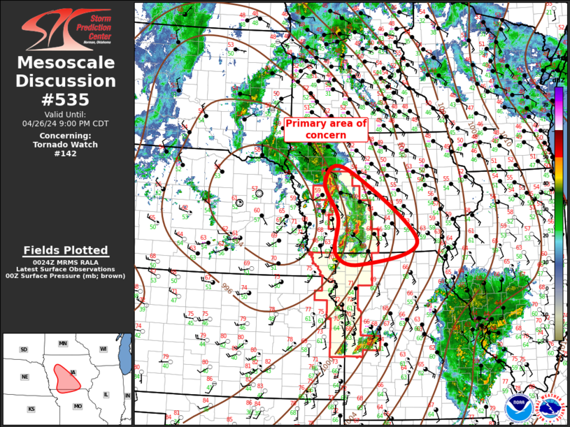
SUMMARY...Isolated supercell thunderstorms over eastern Nebraska
will northeastward, while other storms form over eastern Kansas.
All of these storms will track across the watch area through early
evening, posing a risk of large hail and a few tornadoes.
The tornado watch area is approximately along and 45 statute miles
east and west of a line from 35 miles east northeast of Denison IA
to 45 miles east southeast of Emporia KS. For a complete depiction
of the watch see the associated watch outline update (WOUS64 KWNS
WOU2).
PRECAUTIONARY/PREPAREDNESS ACTIONS...
REMEMBER...A Tornado Watch means conditions are favorable for
tornadoes and severe thunderstorms in and close to the watch
area. Persons in these areas should be on the lookout for
threatening weather conditions and listen for later statements
and possible warnings.
&&
OTHER WATCH INFORMATION...CONTINUE...WW 139...WW 140...WW 141...
AVIATION...Tornadoes and a few severe thunderstorms with hail
surface and aloft to 2.5 inches. Extreme turbulence and surface wind
gusts to 60 knots. A few cumulonimbi with maximum tops to 500. Mean
storm motion vector 23030.
...Hart

   SEL2

   URGENT - IMMEDIATE BROADCAST REQUESTED
   Tornado Watch Number 142
   NWS Storm Prediction Center Norman OK
   345 PM CDT Fri Apr 26 2024

   The NWS Storm Prediction Center has issued a

   * Tornado Watch for portions of
     Southwest Iowa
     Eastern Kansas
     Northwest Missouri

   * Effective this Friday afternoon and evening from 345 PM until
     900 PM CDT.

   * Primary threats include...
     A few tornadoes likely with a couple intense tornadoes possible
     Scattered large hail and isolated very large hail events to 2.5
       inches in diameter likely
     Scattered damaging wind gusts to 70 mph likely

   SUMMARY...Isolated supercell thunderstorms over eastern Nebraska
   will northeastward, while other storms form over eastern Kansas.
   All of these storms will track across the watch area through early
   evening, posing a risk of large hail and a few tornadoes.

   The tornado watch area is approximately along and 45 statute miles
   east and west of a line from 35 miles east northeast of Denison IA
   to 45 miles east southeast of Emporia KS. For a complete depiction
   of the watch see the associated watch outline update (WOUS64 KWNS
   WOU2).

   PRECAUTIONARY/PREPAREDNESS ACTIONS...

   REMEMBER...A Tornado Watch means conditions are favorable for
   tornadoes and severe thunderstorms in and close to the watch
   area. Persons in these areas should be on the lookout for
   threatening weather conditions and listen for later statements
   and possible warnings.

   &&

   OTHER WATCH INFORMATION...CONTINUE...WW 139...WW 140...WW 141...

   AVIATION...Tornadoes and a few severe thunderstorms with hail
   surface and aloft to 2.5 inches. Extreme turbulence and surface wind
   gusts to 60 knots. A few cumulonimbi with maximum tops to 500. Mean
   storm motion vector 23030.

   ...Hart
 Note:
The Aviation Watch (SAW) product is an approximation to the watch area.
The actual watch is depicted by the shaded areas.
Note:
The Aviation Watch (SAW) product is an approximation to the watch area.
The actual watch is depicted by the shaded areas.
   SAW2
   WW 142 TORNADO IA KS MO 262045Z - 270200Z
   AXIS..45 STATUTE MILES EAST AND WEST OF LINE..
   35ENE DNS/DENISON IA/ - 45ESE EMP/EMPORIA KS/
   ..AVIATION COORDS.. 40NM E/W /33SW FOD - 45WSW BUM/
   HAIL SURFACE AND ALOFT..2.5 INCHES. WIND GUSTS..60 KNOTS.
   MAX TOPS TO 500. MEAN STORM MOTION VECTOR 23030.

   LAT...LON 42179387 38089459 38089624 42179563

   THIS IS AN APPROXIMATION TO THE WATCH AREA.  FOR A
   COMPLETE DEPICTION OF THE WATCH SEE WOUS64 KWNS
   FOR WOU2.
Watch 142 Status Report Messages:
STATUS REPORT #4 ON WW 142

VALID 270040Z - 270140Z

SEVERE WEATHER THREAT CONTINUES RIGHT OF A LINE FROM 45 ENE CNU
TO 30 SSE OJC TO 25 WSW SZL TO 30 SSE LWD TO 30 ENE FNB TO 55 W
DSM TO 15 SE DNS TO 25 NW DNS.

..WENDT..04/27/24

ATTN...WFO...DMX...TOP...EAX...

&&

STATUS REPORT FOR WT 142

SEVERE WEATHER THREAT CONTINUES FOR THE FOLLOWING AREAS

IAC001-003-009-025-027-039-047-049-053-073-077-121-159-161-173-
175-270140-

IA
.    IOWA COUNTIES INCLUDED ARE

ADAIR		     ADAMS		 AUDUBON
CALHOUN 	     CARROLL		 CLARKE
CRAWFORD	     DALLAS		 DECATUR
GREENE		     GUTHRIE		 MADISON
RINGGOLD	     SAC		 TAYLOR
UNION
$$


MOC013-075-081-083-147-227-270140-

MO
.    MISSOURI COUNTIES INCLUDED ARE

BATES		     GENTRY		 HARRISON
HENRY		     NODAWAY		 WORTH
$$


THE WATCH STATUS MESSAGE IS FOR GUIDANCE PURPOSES ONLY.  PLEASE
REFER TO WATCH COUNTY NOTIFICATION STATEMENTS FOR OFFICIAL
INFORMATION ON COUNTIES...INDEPENDENT CITIES AND MARINE ZONES
CLEARED FROM SEVERE THUNDERSTORM AND TORNADO WATCHES.
$$

STATUS REPORT #3 ON WW 142

VALID 262335Z - 270040Z

SEVERE WEATHER THREAT CONTINUES RIGHT OF A LINE FROM 15 WNW EMP
TO 35 SSW FNB TO FNB TO 25 ENE FNB TO 35 NE SDA TO 25 SSE DNS TO
20 NE TQE.

..WENDT..04/26/24

ATTN...WFO...DMX...TOP...EAX...

&&

STATUS REPORT FOR WT 142

SEVERE WEATHER THREAT CONTINUES FOR THE FOLLOWING AREAS

IAC001-003-009-025-027-029-039-047-049-053-073-077-121-159-161-
173-175-270040-

IA
.    IOWA COUNTIES INCLUDED ARE

ADAIR		     ADAMS		 AUDUBON
CALHOUN 	     CARROLL		 CASS
CLARKE		     CRAWFORD		 DALLAS
DECATUR 	     GREENE		 GUTHRIE
MADISON 	     RINGGOLD		 SAC
TAYLOR		     UNION
$$


KSC003-005-013-031-043-045-059-085-087-091-103-107-111-121-139-
177-197-209-270040-

KS
.    KANSAS COUNTIES INCLUDED ARE

ANDERSON	     ATCHISON		 BROWN
COFFEY		     DONIPHAN		 DOUGLAS
FRANKLIN	     JACKSON		 JEFFERSON
JOHNSON 	     LEAVENWORTH	 LINN
LYON		     MIAMI		 OSAGE
SHAWNEE 	     WABAUNSEE		 WYANDOTTE
$$


MOC003-013-021-037-047-049-061-063-075-081-083-087-095-147-165-
227-270040-

MO
.    MISSOURI COUNTIES INCLUDED ARE

ANDREW		     BATES		 BUCHANAN
CASS		     CLAY		 CLINTON
DAVIESS 	     DEKALB		 GENTRY
HARRISON	     HENRY		 HOLT
JACKSON 	     NODAWAY		 PLATTE
WORTH
$$


THE WATCH STATUS MESSAGE IS FOR GUIDANCE PURPOSES ONLY.  PLEASE
REFER TO WATCH COUNTY NOTIFICATION STATEMENTS FOR OFFICIAL
INFORMATION ON COUNTIES...INDEPENDENT CITIES AND MARINE ZONES
CLEARED FROM SEVERE THUNDERSTORM AND TORNADO WATCHES.
$$

STATUS REPORT #2 ON WW 142

VALID 262255Z - 262340Z

SEVERE WEATHER THREAT CONTINUES RIGHT OF A LINE FROM 25 S MHK TO
30 NNW TOP TO 5 SW FNB TO 25 W SDA.

..WENDT..04/26/24

ATTN...WFO...DMX...TOP...EAX...

&&

STATUS REPORT FOR WT 142

SEVERE WEATHER THREAT CONTINUES FOR THE FOLLOWING AREAS

IAC001-003-009-025-027-029-039-047-049-053-073-077-121-159-161-
173-175-262340-

IA
.    IOWA COUNTIES INCLUDED ARE

ADAIR		     ADAMS		 AUDUBON
CALHOUN 	     CARROLL		 CASS
CLARKE		     CRAWFORD		 DALLAS
DECATUR 	     GREENE		 GUTHRIE
MADISON 	     RINGGOLD		 SAC
TAYLOR		     UNION
$$


KSC003-005-013-031-043-045-059-085-087-091-103-107-111-121-139-
177-197-209-262340-

KS
.    KANSAS COUNTIES INCLUDED ARE

ANDERSON	     ATCHISON		 BROWN
COFFEY		     DONIPHAN		 DOUGLAS
FRANKLIN	     JACKSON		 JEFFERSON
JOHNSON 	     LEAVENWORTH	 LINN
LYON		     MIAMI		 OSAGE
SHAWNEE 	     WABAUNSEE		 WYANDOTTE
$$


MOC003-005-013-021-037-047-049-061-063-075-081-087-095-147-165-
227-262340-

MO
.    MISSOURI COUNTIES INCLUDED ARE

ANDREW		     ATCHISON		 BATES
BUCHANAN	     CASS		 CLAY
CLINTON 	     DAVIESS		 DEKALB
GENTRY		     HARRISON		 HOLT
JACKSON 	     NODAWAY		 PLATTE
WORTH
$$


THE WATCH STATUS MESSAGE IS FOR GUIDANCE PURPOSES ONLY.  PLEASE
REFER TO WATCH COUNTY NOTIFICATION STATEMENTS FOR OFFICIAL
INFORMATION ON COUNTIES...INDEPENDENT CITIES AND MARINE ZONES
CLEARED FROM SEVERE THUNDERSTORM AND TORNADO WATCHES.
$$

STATUS REPORT #1 ON WW 142

VALID 262140Z - 262240Z

THE SEVERE WEATHER THREAT CONTINUES ACROSS THE ENTIRE WATCH AREA.

..WENDT..04/26/24

ATTN...WFO...DMX...TOP...EAX...

&&

STATUS REPORT FOR WT 142

SEVERE WEATHER THREAT CONTINUES FOR THE FOLLOWING AREAS

IAC001-003-009-027-029-039-047-049-053-073-077-121-159-173-175-
262240-

IA
.    IOWA COUNTIES INCLUDED ARE

ADAIR		     ADAMS		 AUDUBON
CARROLL 	     CASS		 CLARKE
CRAWFORD	     DALLAS		 DECATUR
GREENE		     GUTHRIE		 MADISON
RINGGOLD	     TAYLOR		 UNION
$$


KSC003-005-013-031-043-045-059-085-087-091-103-107-111-121-131-
139-149-177-197-209-262240-

KS
.    KANSAS COUNTIES INCLUDED ARE

ANDERSON	     ATCHISON		 BROWN
COFFEY		     DONIPHAN		 DOUGLAS
FRANKLIN	     JACKSON		 JEFFERSON
JOHNSON 	     LEAVENWORTH	 LINN
LYON		     MIAMI		 NEMAHA
OSAGE		     POTTAWATOMIE	 SHAWNEE
WABAUNSEE	     WYANDOTTE
$$


MOC003-005-013-021-037-047-049-061-063-075-081-087-095-147-165-
227-262240-

MO
.    MISSOURI COUNTIES INCLUDED ARE

ANDREW		     ATCHISON		 BATES
BUCHANAN	     CASS		 CLAY
CLINTON 	     DAVIESS		 DEKALB
GENTRY		     HARRISON		 HOLT
JACKSON 	     NODAWAY		 PLATTE
WORTH
$$


THE WATCH STATUS MESSAGE IS FOR GUIDANCE PURPOSES ONLY.  PLEASE
REFER TO WATCH COUNTY NOTIFICATION STATEMENTS FOR OFFICIAL
INFORMATION ON COUNTIES...INDEPENDENT CITIES AND MARINE ZONES
CLEARED FROM SEVERE THUNDERSTORM AND TORNADO WATCHES.
$$
Note:
Click for Complete Product Text.
Tornadoes
Probability of 2 or more tornadoes
|
Mod (60%)
|
Probability of 1 or more strong (EF2-EF5) tornadoes
|
Mod (40%)
|
Wind
Probability of 10 or more severe wind events
|
Mod (60%)
|
Probability of 1 or more wind events > 65 knots
|
Low (20%)
|
Hail
Probability of 10 or more severe hail events
|
High (70%)
|
Probability of 1 or more hailstones > 2 inches
|
High (70%)
|
Combined Severe Hail/Wind
Probability of 6 or more combined severe hail/wind events
|
High (>95%)
|
For each watch, probabilities for particular events inside the watch
(listed above in each table) are determined by the issuing forecaster.
The "Low" category contains probability values ranging from less than 2%
to 20% (EF2-EF5 tornadoes), less than 5% to 20% (all other probabilities),
"Moderate" from 30% to 60%, and "High" from 70% to greater than 95%.
High values are bolded and lighter in color to provide awareness of
an increased threat for a particular event.


 @NWSSPC