 Note:
The expiration time in the watch graphic is amended if the watch is
replaced, cancelled or extended.
Note:
Note:
The expiration time in the watch graphic is amended if the watch is
replaced, cancelled or extended.
Note: Click for
Watch Status Reports.
SEL1
URGENT - IMMEDIATE BROADCAST REQUESTED
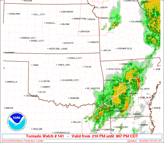
Tornado Watch Number 141
NWS Storm Prediction Center Norman OK
210 PM CDT Fri Apr 26 2024
The NWS Storm Prediction Center has issued a
* Tornado Watch for portions of
Southeast Kansas
Eastern Oklahoma
* Effective this Friday afternoon and evening from 210 PM until
900 PM CDT.
* Primary threats include...
A few tornadoes likely with a couple intense tornadoes possible
Scattered large hail and isolated very large hail events to 3
inches in diameter likely
Scattered damaging wind gusts to 70 mph possible
SUMMARY...Isolated thunderstorms are beginning to form along a
dryline over southeast Kansas and central Oklahoma. This activity
may remain widely scattered, but those storms that form will pose a
risk of very large hail and a few tornadoes. Strong tornadoes are
possible.
The tornado watch area is approximately along and 65 statute miles
east and west of a line from 25 miles north northeast of Chanute KS
to 20 miles east of Durant OK. For a complete depiction of the watch
see the associated watch outline update (WOUS64 KWNS WOU1).
PRECAUTIONARY/PREPAREDNESS ACTIONS...
REMEMBER...A Tornado Watch means conditions are favorable for
tornadoes and severe thunderstorms in and close to the watch
area. Persons in these areas should be on the lookout for
threatening weather conditions and listen for later statements
and possible warnings.
&&
OTHER WATCH INFORMATION...CONTINUE...WW 139...WW 140...
AVIATION...Tornadoes and a few severe thunderstorms with hail
surface and aloft to 3 inches. Extreme turbulence and surface wind
gusts to 60 knots. A few cumulonimbi with maximum tops to 500. Mean
storm motion vector 25035.
...Hart
   SEL1

   URGENT - IMMEDIATE BROADCAST REQUESTED
   Tornado Watch Number 141
   NWS Storm Prediction Center Norman OK
   210 PM CDT Fri Apr 26 2024

   The NWS Storm Prediction Center has issued a

   * Tornado Watch for portions of
     Southeast Kansas
     Eastern Oklahoma

   * Effective this Friday afternoon and evening from 210 PM until
     900 PM CDT.

   * Primary threats include...
     A few tornadoes likely with a couple intense tornadoes possible
     Scattered large hail and isolated very large hail events to 3
       inches in diameter likely
     Scattered damaging wind gusts to 70 mph possible

   SUMMARY...Isolated thunderstorms are beginning to form along a
   dryline over southeast Kansas and central Oklahoma.  This activity
   may remain widely scattered, but those storms that form will pose a
   risk of very large hail and a few tornadoes.  Strong tornadoes are
   possible.

   The tornado watch area is approximately along and 65 statute miles
   east and west of a line from 25 miles north northeast of Chanute KS
   to 20 miles east of Durant OK. For a complete depiction of the watch
   see the associated watch outline update (WOUS64 KWNS WOU1).

   PRECAUTIONARY/PREPAREDNESS ACTIONS...

   REMEMBER...A Tornado Watch means conditions are favorable for
   tornadoes and severe thunderstorms in and close to the watch
   area. Persons in these areas should be on the lookout for
   threatening weather conditions and listen for later statements
   and possible warnings.

   &&

   OTHER WATCH INFORMATION...CONTINUE...WW 139...WW 140...

   AVIATION...Tornadoes and a few severe thunderstorms with hail
   surface and aloft to 3 inches. Extreme turbulence and surface wind
   gusts to 60 knots. A few cumulonimbi with maximum tops to 500. Mean
   storm motion vector 25035.

   ...Hart
 Note:
The Aviation Watch (SAW) product is an approximation to the watch area.
The actual watch is depicted by the shaded areas.
Note:
The Aviation Watch (SAW) product is an approximation to the watch area.
The actual watch is depicted by the shaded areas.
SAW1
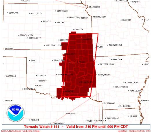
WW 141 TORNADO KS OK 261910Z - 270200Z
AXIS..65 STATUTE MILES EAST AND WEST OF LINE..
25NNE CNU/CHANUTE KS/ - 20E DUA/DURANT OK/
..AVIATION COORDS.. 55NM E/W /42WSW BUM - 56SSW MLC/
HAIL SURFACE AND ALOFT..3 INCHES. WIND GUSTS..60 KNOTS.
MAX TOPS TO 500. MEAN STORM MOTION VECTOR 25035.
LAT...LON 38009411 33939492 33939719 38009650
THIS IS AN APPROXIMATION TO THE WATCH AREA. FOR A
COMPLETE DEPICTION OF THE WATCH SEE WOUS64 KWNS
FOR WOU1.
Watch 141 Status Report Messages:
STATUS REPORT #5 ON WW 141

VALID 262330Z - 270040Z

SEVERE WEATHER THREAT CONTINUES RIGHT OF A LINE FROM 15 WNW UMN
TO 15 NNE BVO TO 15 SE EMP.

..WENDT..04/26/24

ATTN...WFO...ICT...SGF...TSA...OUN...

&&

STATUS REPORT FOR WT 141

SEVERE WEATHER THREAT CONTINUES FOR THE FOLLOWING AREAS

KSC001-011-021-037-099-125-133-205-207-270040-

KS
.    KANSAS COUNTIES INCLUDED ARE

ALLEN		     BOURBON		 CHEROKEE
CRAWFORD	     LABETTE		 MONTGOMERY
NEOSHO		     WILSON		 WOODSON
$$


MOC185-217-270040-

MO
.    MISSOURI COUNTIES INCLUDED ARE

ST. CLAIR	     VERNON
$$


THE WATCH STATUS MESSAGE IS FOR GUIDANCE PURPOSES ONLY.  PLEASE
REFER TO WATCH COUNTY NOTIFICATION STATEMENTS FOR OFFICIAL
INFORMATION ON COUNTIES...INDEPENDENT CITIES AND MARINE ZONES
CLEARED FROM SEVERE THUNDERSTORM AND TORNADO WATCHES.
$$

STATUS REPORT #4 ON WW 141

VALID 262250Z - 262340Z

SEVERE WEATHER THREAT CONTINUES RIGHT OF A LINE FROM 30 N ADM TO
20 SSE CQB TO 25 NW TUL TO 15 NNW BVO TO 30 WNW CNU TO 15 SE EMP.

..WENDT..04/26/24

ATTN...WFO...ICT...SGF...TSA...OUN...

&&

STATUS REPORT FOR WT 141

SEVERE WEATHER THREAT CONTINUES FOR THE FOLLOWING AREAS

KSC001-011-021-037-099-125-133-205-207-262340-

KS
.    KANSAS COUNTIES INCLUDED ARE

ALLEN		     BOURBON		 CHEROKEE
CRAWFORD	     LABETTE		 MONTGOMERY
NEOSHO		     WILSON		 WOODSON
$$


MOC185-217-262340-

MO
.    MISSOURI COUNTIES INCLUDED ARE

ST. CLAIR	     VERNON
$$


OKC001-005-013-019-021-023-029-035-037-041-061-063-069-077-079-
085-091-095-097-099-101-105-107-111-115-121-123-125-127-131-133-
135-143-145-147-262340-

OK
.    OKLAHOMA COUNTIES INCLUDED ARE

ADAIR		     ATOKA		 BRYAN
CARTER		     CHEROKEE		 CHOCTAW
COAL		     CRAIG		 CREEK
DELAWARE	     HASKELL		 HUGHES
JOHNSTON	     LATIMER		 LE FLORE
LOVE		     MCINTOSH		 MARSHALL
MAYES		     MURRAY		 MUSKOGEE
NOWATA		     OKFUSKEE		 OKMULGEE
OTTAWA		     PITTSBURG		 PONTOTOC
POTTAWATOMIE	     PUSHMATAHA 	 ROGERS
SEMINOLE	     SEQUOYAH		 TULSA
WAGONER 	     WASHINGTON
$$


THE WATCH STATUS MESSAGE IS FOR GUIDANCE PURPOSES ONLY.  PLEASE
REFER TO WATCH COUNTY NOTIFICATION STATEMENTS FOR OFFICIAL
INFORMATION ON COUNTIES...INDEPENDENT CITIES AND MARINE ZONES
CLEARED FROM SEVERE THUNDERSTORM AND TORNADO WATCHES.
$$

STATUS REPORT #3 ON WW 141

VALID 262140Z - 262240Z

SEVERE WEATHER THREAT CONTINUES RIGHT OF A LINE FROM 40 N ADM TO
20 SSE CQB TO 30 WNW TUL TO 40 E ICT.

..WENDT..04/26/24

ATTN...WFO...ICT...SGF...TSA...OUN...

&&

STATUS REPORT FOR WT 141

SEVERE WEATHER THREAT CONTINUES FOR THE FOLLOWING AREAS

KSC001-011-019-021-037-049-073-099-125-133-205-207-262240-

KS
.    KANSAS COUNTIES INCLUDED ARE

ALLEN		     BOURBON		 CHAUTAUQUA
CHEROKEE	     CRAWFORD		 ELK
GREENWOOD	     LABETTE		 MONTGOMERY
NEOSHO		     WILSON		 WOODSON
$$


OKC001-005-013-019-021-023-029-035-037-041-061-063-069-077-079-
085-091-095-097-099-101-105-107-111-113-115-121-123-125-127-131-
133-135-143-145-147-262240-

OK
.    OKLAHOMA COUNTIES INCLUDED ARE

ADAIR		     ATOKA		 BRYAN
CARTER		     CHEROKEE		 CHOCTAW
COAL		     CRAIG		 CREEK
DELAWARE	     HASKELL		 HUGHES
JOHNSTON	     LATIMER		 LE FLORE
LOVE		     MCINTOSH		 MARSHALL
MAYES		     MURRAY		 MUSKOGEE
NOWATA		     OKFUSKEE		 OKMULGEE
OSAGE		     OTTAWA		 PITTSBURG
PONTOTOC	     POTTAWATOMIE	 PUSHMATAHA
ROGERS		     SEMINOLE		 SEQUOYAH
TULSA		     WAGONER		 WASHINGTON
$$


THE WATCH STATUS MESSAGE IS FOR GUIDANCE PURPOSES ONLY.  PLEASE
REFER TO WATCH COUNTY NOTIFICATION STATEMENTS FOR OFFICIAL
INFORMATION ON COUNTIES...INDEPENDENT CITIES AND MARINE ZONES
CLEARED FROM SEVERE THUNDERSTORM AND TORNADO WATCHES.
$$

STATUS REPORT #2 ON WW 141

VALID 262035Z - 262140Z

THE SEVERE WEATHER THREAT CONTINUES ACROSS THE ENTIRE WATCH AREA.

..WENDT..04/26/24

ATTN...WFO...ICT...SGF...TSA...OUN...

&&

STATUS REPORT FOR WT 141

SEVERE WEATHER THREAT CONTINUES FOR THE FOLLOWING AREAS

KSC001-011-019-021-035-037-049-073-099-125-133-205-207-262140-

KS
.    KANSAS COUNTIES INCLUDED ARE

ALLEN		     BOURBON		 CHAUTAUQUA
CHEROKEE	     COWLEY		 CRAWFORD
ELK		     GREENWOOD		 LABETTE
MONTGOMERY	     NEOSHO		 WILSON
WOODSON
$$


OKC001-005-013-019-021-023-029-035-037-041-061-063-069-077-079-
081-085-091-095-097-099-101-105-107-111-113-115-117-119-121-123-
125-127-131-133-135-143-145-147-262140-

OK
.    OKLAHOMA COUNTIES INCLUDED ARE

ADAIR		     ATOKA		 BRYAN
CARTER		     CHEROKEE		 CHOCTAW
COAL		     CRAIG		 CREEK
DELAWARE	     HASKELL		 HUGHES
JOHNSTON	     LATIMER		 LE FLORE
LINCOLN 	     LOVE		 MCINTOSH
MARSHALL	     MAYES		 MURRAY
MUSKOGEE	     NOWATA		 OKFUSKEE
OKMULGEE	     OSAGE		 OTTAWA
PAWNEE		     PAYNE		 PITTSBURG
PONTOTOC	     POTTAWATOMIE	 PUSHMATAHA
ROGERS		     SEMINOLE		 SEQUOYAH
TULSA		     WAGONER		 WASHINGTON
$$


THE WATCH STATUS MESSAGE IS FOR GUIDANCE PURPOSES ONLY.  PLEASE
REFER TO WATCH COUNTY NOTIFICATION STATEMENTS FOR OFFICIAL
INFORMATION ON COUNTIES...INDEPENDENT CITIES AND MARINE ZONES
CLEARED FROM SEVERE THUNDERSTORM AND TORNADO WATCHES.
$$

STATUS REPORT #1 ON WW 141

VALID 261930Z - 262040Z

THE SEVERE WEATHER THREAT CONTINUES ACROSS THE ENTIRE WATCH AREA.

..WENDT..04/26/24

ATTN...WFO...ICT...SGF...TSA...OUN...

&&

STATUS REPORT FOR WT 141

SEVERE WEATHER THREAT CONTINUES FOR THE FOLLOWING AREAS

KSC001-011-019-021-035-037-049-073-099-125-133-205-207-262040-

KS
.    KANSAS COUNTIES INCLUDED ARE

ALLEN		     BOURBON		 CHAUTAUQUA
CHEROKEE	     COWLEY		 CRAWFORD
ELK		     GREENWOOD		 LABETTE
MONTGOMERY	     NEOSHO		 WILSON
WOODSON
$$


OKC001-005-013-019-021-023-029-035-037-041-061-063-069-077-079-
081-085-091-095-097-099-101-105-107-111-113-115-117-119-121-123-
125-127-131-133-135-143-145-147-262040-

OK
.    OKLAHOMA COUNTIES INCLUDED ARE

ADAIR		     ATOKA		 BRYAN
CARTER		     CHEROKEE		 CHOCTAW
COAL		     CRAIG		 CREEK
DELAWARE	     HASKELL		 HUGHES
JOHNSTON	     LATIMER		 LE FLORE
LINCOLN 	     LOVE		 MCINTOSH
MARSHALL	     MAYES		 MURRAY
MUSKOGEE	     NOWATA		 OKFUSKEE
OKMULGEE	     OSAGE		 OTTAWA
PAWNEE		     PAYNE		 PITTSBURG
PONTOTOC	     POTTAWATOMIE	 PUSHMATAHA
ROGERS		     SEMINOLE		 SEQUOYAH
TULSA		     WAGONER		 WASHINGTON
$$


THE WATCH STATUS MESSAGE IS FOR GUIDANCE PURPOSES ONLY.  PLEASE
REFER TO WATCH COUNTY NOTIFICATION STATEMENTS FOR OFFICIAL
INFORMATION ON COUNTIES...INDEPENDENT CITIES AND MARINE ZONES
CLEARED FROM SEVERE THUNDERSTORM AND TORNADO WATCHES.
$$
Note:
Click for Complete Product Text.
Tornadoes
Probability of 2 or more tornadoes
|
Mod (60%)
|
Probability of 1 or more strong (EF2-EF5) tornadoes
|
Mod (40%)
|
Wind
Probability of 10 or more severe wind events
|
Mod (40%)
|
Probability of 1 or more wind events > 65 knots
|
Low (20%)
|
Hail
Probability of 10 or more severe hail events
|
High (70%)
|
Probability of 1 or more hailstones > 2 inches
|
Mod (60%)
|
Combined Severe Hail/Wind
Probability of 6 or more combined severe hail/wind events
|
High (90%)
|
For each watch, probabilities for particular events inside the watch
(listed above in each table) are determined by the issuing forecaster.
The "Low" category contains probability values ranging from less than 2%
to 20% (EF2-EF5 tornadoes), less than 5% to 20% (all other probabilities),
"Moderate" from 30% to 60%, and "High" from 70% to greater than 95%.
High values are bolded and lighter in color to provide awareness of
an increased threat for a particular event.


 @NWSSPC


