 Note:
The expiration time in the watch graphic is amended if the watch is
replaced, cancelled or extended.
Note:
Note:
The expiration time in the watch graphic is amended if the watch is
replaced, cancelled or extended.
Note: Click for
Watch Status Reports.
SEL0
URGENT - IMMEDIATE BROADCAST REQUESTED
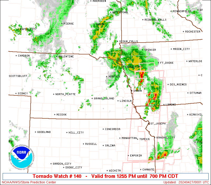
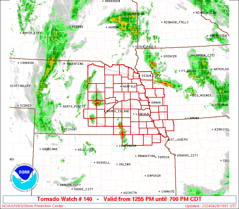
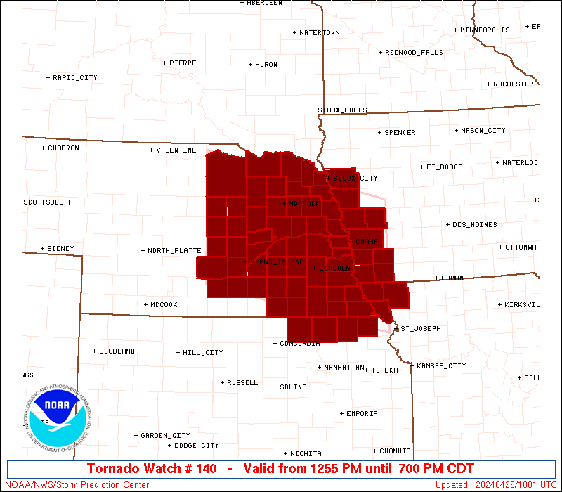
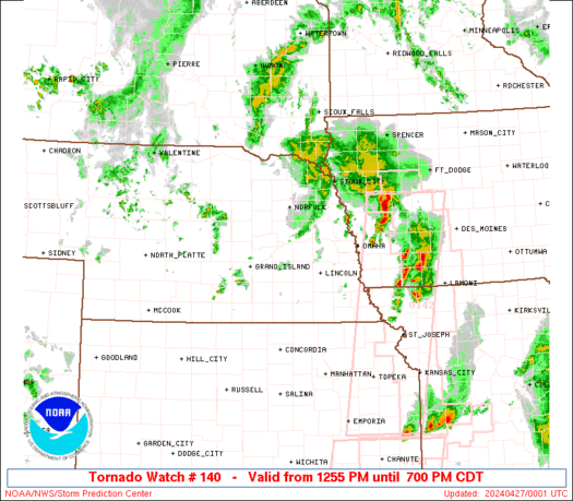
Tornado Watch Number 140
NWS Storm Prediction Center Norman OK
1255 PM CDT Fri Apr 26 2024
The NWS Storm Prediction Center has issued a
* Tornado Watch for portions of
Western Iowa
Northeast Kansas
Northwest Missouri
Eastern Nebraska
* Effective this Friday afternoon and evening from 1255 PM until
700 PM CDT.
* Primary threats include...
A few tornadoes likely with a couple intense tornadoes possible
Widespread large hail and isolated very large hail events to 3
inches in diameter likely
Scattered damaging wind gusts to 70 mph possible
SUMMARY...Thunderstorms are forecast to develop and spread across
the watch area this afternoon. Supercells capable of very large
hail and a few tornadoes are the main threat. A strong tornado is
possible.
The tornado watch area is approximately along and 80 statute miles
north and south of a line from 5 miles southwest of Burwell NE to 20
miles east northeast of Shenandoah IA. For a complete depiction of
the watch see the associated watch outline update (WOUS64 KWNS
WOU0).
PRECAUTIONARY/PREPAREDNESS ACTIONS...
REMEMBER...A Tornado Watch means conditions are favorable for
tornadoes and severe thunderstorms in and close to the watch
area. Persons in these areas should be on the lookout for
threatening weather conditions and listen for later statements
and possible warnings.
&&
OTHER WATCH INFORMATION...CONTINUE...WW 139...
AVIATION...Tornadoes and a few severe thunderstorms with hail
surface and aloft to 3 inches. Extreme turbulence and surface wind
gusts to 60 knots. A few cumulonimbi with maximum tops to 500. Mean
storm motion vector 22030.
...Hart
 Note:
The Aviation Watch (SAW) product is an approximation to the watch area.
The actual watch is depicted by the shaded areas.
Note:
The Aviation Watch (SAW) product is an approximation to the watch area.
The actual watch is depicted by the shaded areas.
   SAW0
   WW 140 TORNADO IA KS MO NE 261755Z - 270000Z
   AXIS..80 STATUTE MILES NORTH AND SOUTH OF LINE..
   5SW BUB/BURWELL NE/ - 20ENE SDA/SHENANDOAH IA/
   ..AVIATION COORDS.. 70NM N/S /44WNW OBH - 36ESE OVR/
   HAIL SURFACE AND ALOFT..3 INCHES. WIND GUSTS..60 KNOTS.
   MAX TOPS TO 500. MEAN STORM MOTION VECTOR 22030.

   LAT...LON 42899922 42029507 39709507 40579922

   THIS IS AN APPROXIMATION TO THE WATCH AREA.  FOR A
   COMPLETE DEPICTION OF THE WATCH SEE WOUS64 KWNS
   FOR WOU0.
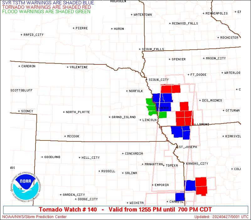
Watch 140 Status Report Messages:
STATUS REPORT #6 ON WW 140
VALID 262330Z - 270040Z
SEVERE WEATHER THREAT CONTINUES RIGHT OF A LINE FROM 15 N STJ TO
20 NE FNB TO 20 N SDA TO 5 NE TQE TO 5 WNW SUX TO 20 NNW SUX.
..WENDT..04/26/24
ATTN...WFO...OAX...FSD...TOP...EAX...GID...LBF...
&&
STATUS REPORT FOR WT 140
SEVERE WEATHER THREAT CONTINUES FOR THE FOLLOWING AREAS
IAC085-093-133-137-145-155-165-193-270040-
IA
. IOWA COUNTIES INCLUDED ARE
HARRISON IDA MONONA
MONTGOMERY PAGE POTTAWATTAMIE
SHELBY WOODBURY
$$
THE WATCH STATUS MESSAGE IS FOR GUIDANCE PURPOSES ONLY. PLEASE
REFER TO WATCH COUNTY NOTIFICATION STATEMENTS FOR OFFICIAL
INFORMATION ON COUNTIES...INDEPENDENT CITIES AND MARINE ZONES
CLEARED FROM SEVERE THUNDERSTORM AND TORNADO WATCHES.
$$
STATUS REPORT #5 ON WW 140
VALID 262245Z - 262340Z
SEVERE WEATHER THREAT CONTINUES RIGHT OF A LINE FROM 25 SW FNB TO
15 NNW FNB TO 25 WSW SDA TO 30 W SDA TO 20 SW OMA TO 35 E OLU TO
20 WNW OLU TO 10 WSW YKN.
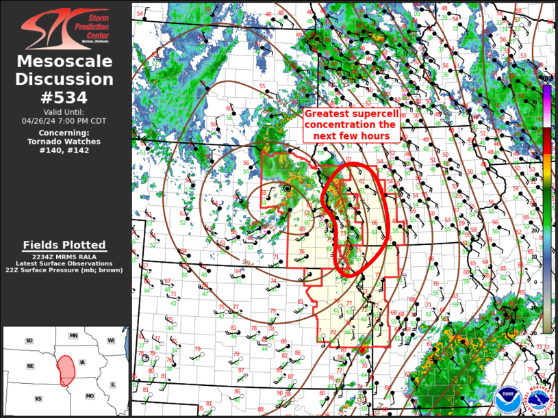
FOR ADDITIONAL INFORMATION SEE MESOSCALE DISCUSSION 534
..WENDT..04/26/24
ATTN...WFO...OAX...FSD...TOP...EAX...GID...LBF...
&&
STATUS REPORT FOR WT 140
SEVERE WEATHER THREAT CONTINUES FOR THE FOLLOWING AREAS
IAC071-085-093-129-133-137-145-155-165-193-262340-
IA
. IOWA COUNTIES INCLUDED ARE
FREMONT HARRISON IDA
MILLS MONONA MONTGOMERY
PAGE POTTAWATTAMIE SHELBY
WOODBURY
$$
NEC021-027-037-039-043-051-053-055-119-139-141-147-153-167-173-
177-179-262340-
NE
. NEBRASKA COUNTIES INCLUDED ARE
BURT CEDAR COLFAX
CUMING DAKOTA DIXON
DODGE DOUGLAS MADISON
PIERCE PLATTE RICHARDSON
SARPY STANTON THURSTON
WASHINGTON WAYNE
$$
THE WATCH STATUS MESSAGE IS FOR GUIDANCE PURPOSES ONLY. PLEASE
REFER TO WATCH COUNTY NOTIFICATION STATEMENTS FOR OFFICIAL
INFORMATION ON COUNTIES...INDEPENDENT CITIES AND MARINE ZONES
CLEARED FROM SEVERE THUNDERSTORM AND TORNADO WATCHES.
$$
STATUS REPORT #4 ON WW 140
VALID 262135Z - 262240Z
SEVERE WEATHER THREAT CONTINUES RIGHT OF A LINE FROM 35 NE MHK TO
25 SE BIE TO 10 NNE LNK TO 20 WSW OLU TO 40 N GRI TO 40 NNE ONL.
..WENDT..04/26/24
ATTN...WFO...OAX...FSD...TOP...EAX...GID...LBF...
&&
STATUS REPORT FOR WT 140
SEVERE WEATHER THREAT CONTINUES FOR THE FOLLOWING AREAS
IAC071-085-129-133-137-145-155-165-193-262240-
IA
. IOWA COUNTIES INCLUDED ARE
FREMONT HARRISON MILLS
MONONA MONTGOMERY PAGE
POTTAWATTAMIE SHELBY WOODBURY
$$
NEC003-011-021-023-025-027-037-039-043-051-053-055-097-107-119-
127-131-133-139-141-147-153-155-167-173-177-179-262240-
NE
. NEBRASKA COUNTIES INCLUDED ARE
ANTELOPE BOONE BURT
BUTLER CASS CEDAR
COLFAX CUMING DAKOTA
DIXON DODGE DOUGLAS
JOHNSON KNOX MADISON
NEMAHA OTOE PAWNEE
PIERCE PLATTE RICHARDSON
SARPY SAUNDERS STANTON
THURSTON WASHINGTON WAYNE
$$
THE WATCH STATUS MESSAGE IS FOR GUIDANCE PURPOSES ONLY. PLEASE
REFER TO WATCH COUNTY NOTIFICATION STATEMENTS FOR OFFICIAL
INFORMATION ON COUNTIES...INDEPENDENT CITIES AND MARINE ZONES
CLEARED FROM SEVERE THUNDERSTORM AND TORNADO WATCHES.
$$
STATUS REPORT #3 ON WW 140
VALID 262045Z - 262140Z
THE SEVERE WEATHER THREAT CONTINUES ACROSS THE ENTIRE WATCH AREA.
FOR ADDITIONAL INFORMATION SEE MESOSCALE DISCUSSION 532
..WENDT..04/26/24
ATTN...WFO...OAX...FSD...TOP...EAX...GID...LBF...
&&
STATUS REPORT FOR WT 140
SEVERE WEATHER THREAT CONTINUES FOR THE FOLLOWING AREAS
IAC071-085-129-133-137-145-155-165-193-262140-
IA
. IOWA COUNTIES INCLUDED ARE
FREMONT HARRISON MILLS
MONONA MONTGOMERY PAGE
POTTAWATTAMIE SHELBY WOODBURY
$$
KSC013-117-131-201-262140-
KS
. KANSAS COUNTIES INCLUDED ARE
BROWN MARSHALL NEMAHA
WASHINGTON
$$
MOC005-087-147-262140-
MO
. MISSOURI COUNTIES INCLUDED ARE
ATCHISON HOLT NODAWAY
$$
NEC001-003-011-019-021-023-025-027-035-037-039-043-051-053-055-
059-067-071-077-079-081-089-093-095-097-099-107-109-119-121-125-
127-131-133-139-141-143-147-151-153-155-159-163-167-169-173-175-
177-179-183-185-262140-
NE
. NEBRASKA COUNTIES INCLUDED ARE
ADAMS ANTELOPE BOONE
BUFFALO BURT BUTLER
CASS CEDAR CLAY
COLFAX CUMING DAKOTA
DIXON DODGE DOUGLAS
FILLMORE GAGE GARFIELD
GREELEY HALL HAMILTON
HOLT HOWARD JEFFERSON
JOHNSON KEARNEY KNOX
LANCASTER MADISON MERRICK
NANCE NEMAHA OTOE
PAWNEE PIERCE PLATTE
POLK RICHARDSON SALINE
SARPY SAUNDERS SEWARD
SHERMAN STANTON THAYER
THURSTON VALLEY WASHINGTON
WAYNE WHEELER YORK
$$
THE WATCH STATUS MESSAGE IS FOR GUIDANCE PURPOSES ONLY. PLEASE
REFER TO WATCH COUNTY NOTIFICATION STATEMENTS FOR OFFICIAL
INFORMATION ON COUNTIES...INDEPENDENT CITIES AND MARINE ZONES
CLEARED FROM SEVERE THUNDERSTORM AND TORNADO WATCHES.
$$
STATUS REPORT #2 ON WW 140
VALID 261930Z - 262040Z
THE SEVERE WEATHER THREAT CONTINUES ACROSS THE ENTIRE WATCH AREA.
..WENDT..04/26/24
ATTN...WFO...OAX...FSD...TOP...EAX...GID...LBF...
&&
STATUS REPORT FOR WT 140
SEVERE WEATHER THREAT CONTINUES FOR THE FOLLOWING AREAS
IAC071-085-129-133-137-145-155-165-193-262040-
IA
. IOWA COUNTIES INCLUDED ARE
FREMONT HARRISON MILLS
MONONA MONTGOMERY PAGE
POTTAWATTAMIE SHELBY WOODBURY
$$
KSC013-117-131-201-262040-
KS
. KANSAS COUNTIES INCLUDED ARE
BROWN MARSHALL NEMAHA
WASHINGTON
$$
MOC005-087-147-262040-
MO
. MISSOURI COUNTIES INCLUDED ARE
ATCHISON HOLT NODAWAY
$$
NEC001-003-011-019-021-023-025-027-035-037-039-043-051-053-055-
059-067-071-077-079-081-089-093-095-097-099-107-109-119-121-125-
127-131-133-139-141-143-147-151-153-155-159-163-167-169-173-175-
177-179-183-185-262040-
NE
. NEBRASKA COUNTIES INCLUDED ARE
ADAMS ANTELOPE BOONE
BUFFALO BURT BUTLER
CASS CEDAR CLAY
COLFAX CUMING DAKOTA
DIXON DODGE DOUGLAS
FILLMORE GAGE GARFIELD
GREELEY HALL HAMILTON
HOLT HOWARD JEFFERSON
JOHNSON KEARNEY KNOX
LANCASTER MADISON MERRICK
NANCE NEMAHA OTOE
PAWNEE PIERCE PLATTE
POLK RICHARDSON SALINE
SARPY SAUNDERS SEWARD
SHERMAN STANTON THAYER
THURSTON VALLEY WASHINGTON
WAYNE WHEELER YORK
$$
THE WATCH STATUS MESSAGE IS FOR GUIDANCE PURPOSES ONLY. PLEASE
REFER TO WATCH COUNTY NOTIFICATION STATEMENTS FOR OFFICIAL
INFORMATION ON COUNTIES...INDEPENDENT CITIES AND MARINE ZONES
CLEARED FROM SEVERE THUNDERSTORM AND TORNADO WATCHES.
$$
STATUS REPORT #1 ON WW 140
VALID 261825Z - 261940Z
THE SEVERE WEATHER THREAT CONTINUES ACROSS THE ENTIRE WATCH AREA.
..WENDT..04/26/24
ATTN...WFO...OAX...FSD...TOP...EAX...GID...LBF...
&&
STATUS REPORT FOR WT 140
SEVERE WEATHER THREAT CONTINUES FOR THE FOLLOWING AREAS
IAC071-085-129-133-137-145-155-165-193-261940-
IA
. IOWA COUNTIES INCLUDED ARE
FREMONT HARRISON MILLS
MONONA MONTGOMERY PAGE
POTTAWATTAMIE SHELBY WOODBURY
$$
KSC013-117-131-201-261940-
KS
. KANSAS COUNTIES INCLUDED ARE
BROWN MARSHALL NEMAHA
WASHINGTON
$$
MOC005-087-147-261940-
MO
. MISSOURI COUNTIES INCLUDED ARE
ATCHISON HOLT NODAWAY
$$
NEC001-003-011-019-021-023-025-027-035-037-039-043-051-053-055-
059-067-071-077-079-081-089-093-095-097-099-107-109-119-121-125-
127-131-133-139-141-143-147-151-153-155-159-163-167-169-173-175-
177-179-183-185-261940-
NE
. NEBRASKA COUNTIES INCLUDED ARE
ADAMS ANTELOPE BOONE
BUFFALO BURT BUTLER
CASS CEDAR CLAY
COLFAX CUMING DAKOTA
DIXON DODGE DOUGLAS
FILLMORE GAGE GARFIELD
GREELEY HALL HAMILTON
HOLT HOWARD JEFFERSON
JOHNSON KEARNEY KNOX
LANCASTER MADISON MERRICK
NANCE NEMAHA OTOE
PAWNEE PIERCE PLATTE
POLK RICHARDSON SALINE
SARPY SAUNDERS SEWARD
SHERMAN STANTON THAYER
THURSTON VALLEY WASHINGTON
WAYNE WHEELER YORK
$$
THE WATCH STATUS MESSAGE IS FOR GUIDANCE PURPOSES ONLY. PLEASE
REFER TO WATCH COUNTY NOTIFICATION STATEMENTS FOR OFFICIAL
INFORMATION ON COUNTIES...INDEPENDENT CITIES AND MARINE ZONES
CLEARED FROM SEVERE THUNDERSTORM AND TORNADO WATCHES.
$$
Note:
Click for Complete Product Text.
Tornadoes
Probability of 2 or more tornadoes
|
Mod (60%)
|
Probability of 1 or more strong (EF2-EF5) tornadoes
|
Mod (40%)
|
Wind
Probability of 10 or more severe wind events
|
Mod (40%)
|
Probability of 1 or more wind events > 65 knots
|
Low (20%)
|
Hail
Probability of 10 or more severe hail events
|
High (80%)
|
Probability of 1 or more hailstones > 2 inches
|
Mod (60%)
|
Combined Severe Hail/Wind
Probability of 6 or more combined severe hail/wind events
|
High (>95%)
|
For each watch, probabilities for particular events inside the watch
(listed above in each table) are determined by the issuing forecaster.
The "Low" category contains probability values ranging from less than 2%
to 20% (EF2-EF5 tornadoes), less than 5% to 20% (all other probabilities),
"Moderate" from 30% to 60%, and "High" from 70% to greater than 95%.
High values are bolded and lighter in color to provide awareness of
an increased threat for a particular event.


 @NWSSPC