|
| Mesoscale Discussion 534 |
|
< Previous MD Next MD >
|
|
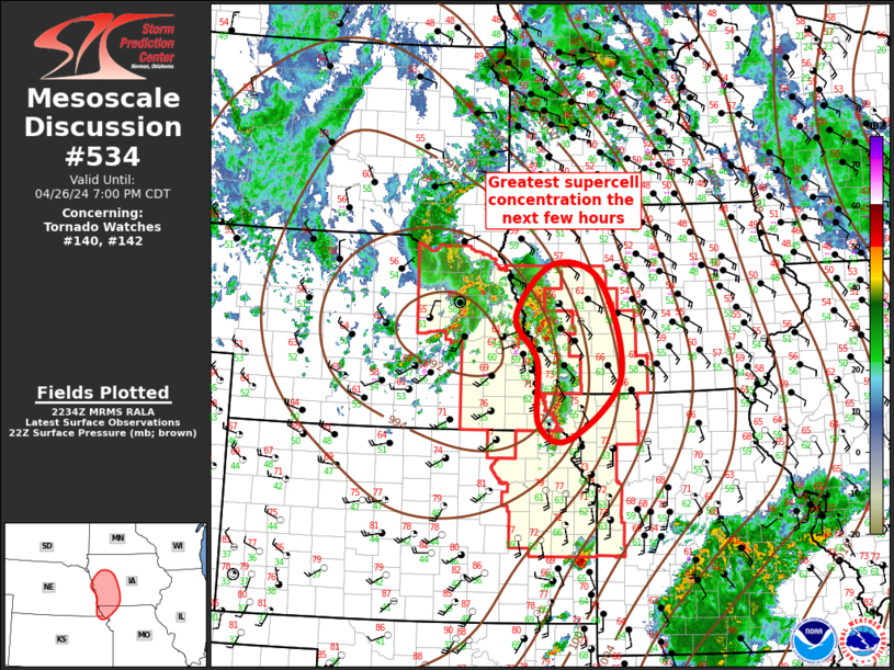
   Mesoscale Discussion 0534
   NWS Storm Prediction Center Norman OK
   0536 PM CDT Fri Apr 26 2024

   Areas affected...Mid Missouri Valley

   Concerning...Tornado Watch 140...142...

   Valid 262236Z - 270000Z

   The severe weather threat for Tornado Watch 140, 142 continues.

   SUMMARY...Supercells, and attendant severe threat, will spread
   northeast across western IA/northwest MO.

   DISCUSSION...Exit region of mid-level jet is spreading northeast
   ahead of ejecting short-wave trough. Boundary-layer air mass is
   stubbornly recovering across central IA where mid 50s surface dew
   points persist. Partial clearing across southwestern IA has
   contributed to surface temperatures warming into the lower 70s, and
   lower 60s dew points have now advanced into Crawford/Audubon County.
   Forecast soundings suggest 60F dew points are needed for
   surface-based buoyancy and additional recovery is expected into
   central IA later this evening.

   Around a half dozen well-defined, long-lived supercells are now
   advancing east of the MO River into western IA. Per 60F dew points,
   air mass immediately downstream is adequately buoyant for
   maintaining robust updrafts. Tornado threat continues until updrafts
   encounter cooler conditions farther downstream.

   ..Darrow.. 04/26/2024

   ...Please see www.spc.noaa.gov for graphic product...

   ATTN...WFO...DMX...EAX...FSD...OAX...TOP...

   LAT...LON   42589550 42329451 40819410 39869514 40099577 41079581
               41769625 42589550
|
|
Top/All Mesoscale Discussions/Forecast Products/Home
|
|


 @NWSSPC