 Note:
The expiration time in the watch graphic is amended if the watch is
replaced, cancelled or extended.
Note:
Note:
The expiration time in the watch graphic is amended if the watch is
replaced, cancelled or extended.
Note: Click for
Watch Status Reports.
SEL6
URGENT - IMMEDIATE BROADCAST REQUESTED
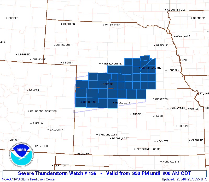
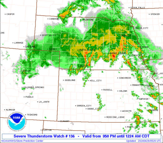
Severe Thunderstorm Watch Number 136
NWS Storm Prediction Center Norman OK
950 PM CDT Thu Apr 25 2024
The NWS Storm Prediction Center has issued a
* Severe Thunderstorm Watch for portions of
northwestern and north-central Kansas
southwestern and south-central Nebraska
* Effective this Thursday night and Friday morning from 950 PM
until 200 AM CDT.
* Primary threats include...
Scattered large hail events to 1.5 inches in diameter possible
Isolated damaging wind gusts to 60 mph possible
SUMMARY...Thunderstorms are expected to continue moving
northeastward across portions of northern Kansas and southern
Nebraska over the next several hours. The strongest storms will be
capable of producing large hail, and locally gusty winds.
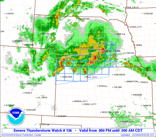
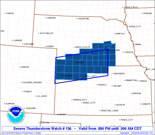
The severe thunderstorm watch area is approximately along and 55
statute miles north and south of a line from 30 miles northwest of
Goodland KS to 35 miles southeast of Hastings NE. For a complete
depiction of the watch see the associated watch outline update
(WOUS64 KWNS WOU6).
PRECAUTIONARY/PREPAREDNESS ACTIONS...
REMEMBER...A Severe Thunderstorm Watch means conditions are
favorable for severe thunderstorms in and close to the watch area.
Persons in these areas should be on the lookout for threatening
weather conditions and listen for later statements and possible
warnings. Severe thunderstorms can and occasionally do produce
tornadoes.
&&
OTHER WATCH INFORMATION...This severe thunderstorm watch replaces
tornado watch number 133. Watch number 133 will not be in effect
after 950 PM CDT. CONTINUE...WW 135...
AVIATION...A few severe thunderstorms with hail surface and aloft to
1.5 inches. Extreme turbulence and surface wind gusts to 50 knots. A
few cumulonimbi with maximum tops to 450. Mean storm motion vector
22040.
...Goss
   SEL6

   URGENT - IMMEDIATE BROADCAST REQUESTED
   Severe Thunderstorm Watch Number 136
   NWS Storm Prediction Center Norman OK
   950 PM CDT Thu Apr 25 2024

   The NWS Storm Prediction Center has issued a

   * Severe Thunderstorm Watch for portions of
     northwestern and north-central Kansas
     southwestern and south-central Nebraska

   * Effective this Thursday night and Friday morning from 950 PM
     until 200 AM CDT.

   * Primary threats include...
     Scattered large hail events to 1.5 inches in diameter possible
     Isolated damaging wind gusts to 60 mph possible

   SUMMARY...Thunderstorms are expected to continue moving
   northeastward across portions of northern Kansas and southern
   Nebraska over the next several hours.  The strongest storms will be
   capable of producing large hail, and locally gusty winds.

   The severe thunderstorm watch area is approximately along and 55
   statute miles north and south of a line from 30 miles northwest of
   Goodland KS to 35 miles southeast of Hastings NE. For a complete
   depiction of the watch see the associated watch outline update
   (WOUS64 KWNS WOU6).

   PRECAUTIONARY/PREPAREDNESS ACTIONS...

   REMEMBER...A Severe Thunderstorm Watch means conditions are
   favorable for severe thunderstorms in and close to the watch area.
   Persons in these areas should be on the lookout for threatening
   weather conditions and listen for later statements and possible
   warnings. Severe thunderstorms can and occasionally do produce
   tornadoes.

   &&

   OTHER WATCH INFORMATION...This severe thunderstorm watch replaces
   tornado watch number 133. Watch number 133 will not be in effect
   after 950 PM CDT. CONTINUE...WW 135...

   AVIATION...A few severe thunderstorms with hail surface and aloft to
   1.5 inches. Extreme turbulence and surface wind gusts to 50 knots. A
   few cumulonimbi with maximum tops to 450. Mean storm motion vector
   22040.

   ...Goss
 Note:
The Aviation Watch (SAW) product is an approximation to the watch area.
The actual watch is depicted by the shaded areas.
Note:
The Aviation Watch (SAW) product is an approximation to the watch area.
The actual watch is depicted by the shaded areas.
   SAW6
   WW 136 SEVERE TSTM KS NE 260250Z - 260700Z
   AXIS..55 STATUTE MILES NORTH AND SOUTH OF LINE..
   30NW GLD/GOODLAND KS/ - 35SE HSI/HASTINGS NE/
   ..AVIATION COORDS.. 50NM N/S /25NW GLD - 71SSE OBH/
   HAIL SURFACE AND ALOFT..1.5 INCHES. WIND GUSTS..50 KNOTS.
   MAX TOPS TO 450. MEAN STORM MOTION VECTOR 22040.

   REPLACES WW 133..CO KS NE

   LAT...LON 40460210 41049796 39439796 38870210

   THIS IS AN APPROXIMATION TO THE WATCH AREA.  FOR A
   COMPLETE DEPICTION OF THE WATCH SEE WOUS64 KWNS
   FOR WOU6.
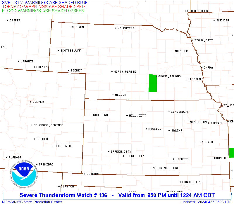
Watch 136 Status Report Messages:
STATUS REPORT #2 ON WW 136

VALID 260425Z - 260540Z

SEVERE WEATHER THREAT CONTINUES RIGHT OF A LINE FROM 15 NE HLC TO
35 NNE HLC TO 10 WSW MCK TO 25 ENE IML.

..GOSS..04/26/24

ATTN...WFO...GLD...GID...LBF...

&&

STATUS REPORT FOR WS 136

SEVERE WEATHER THREAT CONTINUES FOR THE FOLLOWING AREAS

KSC089-147-183-260540-

KS
.    KANSAS COUNTIES INCLUDED ARE

JEWELL		     PHILLIPS		 SMITH
$$


NEC001-019-035-047-059-061-063-065-073-079-081-083-085-093-099-
121-125-129-137-143-145-163-169-181-185-260540-

NE
.    NEBRASKA COUNTIES INCLUDED ARE

ADAMS		     BUFFALO		 CLAY
DAWSON		     FILLMORE		 FRANKLIN
FRONTIER	     FURNAS		 GOSPER
HALL		     HAMILTON		 HARLAN
HAYES		     HOWARD		 KEARNEY
MERRICK 	     NANCE		 NUCKOLLS
PHELPS		     POLK		 RED WILLOW
SHERMAN 	     THAYER		 WEBSTER
YORK
$$


THE WATCH STATUS MESSAGE IS FOR GUIDANCE PURPOSES ONLY.  PLEASE
REFER TO WATCH COUNTY NOTIFICATION STATEMENTS FOR OFFICIAL
INFORMATION ON COUNTIES...INDEPENDENT CITIES AND MARINE ZONES
CLEARED FROM SEVERE THUNDERSTORM AND TORNADO WATCHES.
$$

STATUS REPORT #1 ON WW 136

VALID 260420Z - 260540Z

THE SEVERE WEATHER THREAT CONTINUES ACROSS THE ENTIRE WATCH AREA.

..GOSS..04/26/24

ATTN...WFO...GLD...GID...LBF...

&&

STATUS REPORT FOR WS 136

SEVERE WEATHER THREAT CONTINUES FOR THE FOLLOWING AREAS

KSC023-039-065-089-137-147-153-179-181-183-193-260540-

KS
.    KANSAS COUNTIES INCLUDED ARE

CHEYENNE	     DECATUR		 GRAHAM
JEWELL		     NORTON		 PHILLIPS
RAWLINS 	     SHERIDAN		 SHERMAN
SMITH		     THOMAS
$$


NEC001-019-035-047-057-059-061-063-065-073-079-081-083-085-087-
093-099-121-125-129-137-143-145-163-169-181-185-260540-

NE
.    NEBRASKA COUNTIES INCLUDED ARE

ADAMS		     BUFFALO		 CLAY
DAWSON		     DUNDY		 FILLMORE
FRANKLIN	     FRONTIER		 FURNAS
GOSPER		     HALL		 HAMILTON
HARLAN		     HAYES		 HITCHCOCK
HOWARD		     KEARNEY		 MERRICK
NANCE		     NUCKOLLS		 PHELPS
POLK		     RED WILLOW 	 SHERMAN
THAYER		     WEBSTER		 YORK
$$


THE WATCH STATUS MESSAGE IS FOR GUIDANCE PURPOSES ONLY.  PLEASE
REFER TO WATCH COUNTY NOTIFICATION STATEMENTS FOR OFFICIAL
INFORMATION ON COUNTIES...INDEPENDENT CITIES AND MARINE ZONES
CLEARED FROM SEVERE THUNDERSTORM AND TORNADO WATCHES.
$$
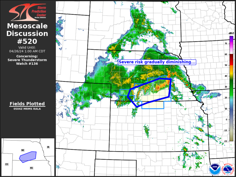
Note:
Click for Complete Product Text.
Tornadoes
Probability of 2 or more tornadoes
|
Low (10%)
|
Probability of 1 or more strong (EF2-EF5) tornadoes
|
Low (5%)
|
Wind
Probability of 10 or more severe wind events
|
Low (20%)
|
Probability of 1 or more wind events > 65 knots
|
Low (10%)
|
Hail
Probability of 10 or more severe hail events
|
Mod (50%)
|
Probability of 1 or more hailstones > 2 inches
|
Low (10%)
|
Combined Severe Hail/Wind
Probability of 6 or more combined severe hail/wind events
|
High (70%)
|
For each watch, probabilities for particular events inside the watch
(listed above in each table) are determined by the issuing forecaster.
The "Low" category contains probability values ranging from less than 2%
to 20% (EF2-EF5 tornadoes), less than 5% to 20% (all other probabilities),
"Moderate" from 30% to 60%, and "High" from 70% to greater than 95%.
High values are bolded and lighter in color to provide awareness of
an increased threat for a particular event.


 @NWSSPC