 Note:
The expiration time in the watch graphic is amended if the watch is
replaced, cancelled or extended.
Note:
Note:
The expiration time in the watch graphic is amended if the watch is
replaced, cancelled or extended.
Note: Click for
Watch Status Reports.
SEL4
URGENT - IMMEDIATE BROADCAST REQUESTED
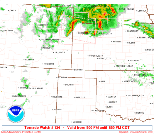
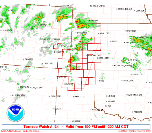
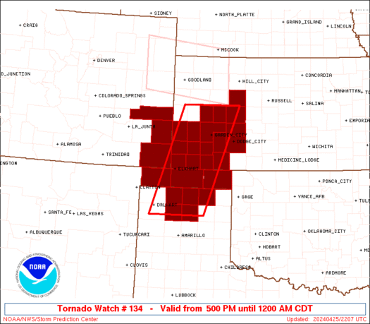
Tornado Watch Number 134
NWS Storm Prediction Center Norman OK
500 PM CDT Thu Apr 25 2024
The NWS Storm Prediction Center has issued a
* Tornado Watch for portions of
Southeastern Colorado
Western Kansas
Oklahoma Panhandle
Northern Texas Panhandle
* Effective this Thursday afternoon from 500 PM until Midnight
CDT.
* Primary threats include...
A few tornadoes and a couple intense tornadoes possible
Scattered large hail and isolated very large hail events to 3
inches in diameter likely
Scattered damaging winds and isolated significant gusts to 75
mph possible
SUMMARY...Isolated to scattered thunderstorms are expected to evolve
out of a belt of convection now building along a slow-moving
dryline, from near the CO/KS line southward into the northern TX
Panhandle. A few supercells may evolve out of this activity with an
early threat for large to very large hail and severe gusts. Tornado
potential would ramp up from late afternoon into evening with any
remaining supercell(s) as low-level shear increases.
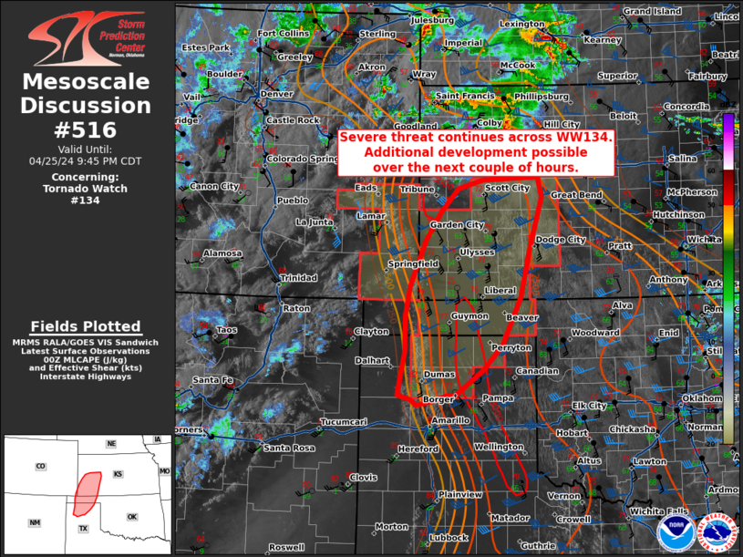
The tornado watch area is approximately along and 50 statute miles
east and west of a line from 45 miles east southeast of Dalhart TX
to 55 miles north of Garden City KS. For a complete depiction of the
watch see the associated watch outline update (WOUS64 KWNS WOU4).
PRECAUTIONARY/PREPAREDNESS ACTIONS...
REMEMBER...A Tornado Watch means conditions are favorable for
tornadoes and severe thunderstorms in and close to the watch
area. Persons in these areas should be on the lookout for
threatening weather conditions and listen for later statements
and possible warnings.
&&
OTHER WATCH INFORMATION...CONTINUE...WW 133...
AVIATION...Tornadoes and a few severe thunderstorms with hail
surface and aloft to 3 inches. Extreme turbulence and surface wind
gusts to 65 knots. A few cumulonimbi with maximum tops to 550. Mean
storm motion vector 23025.
...Edwards
   SEL4

   URGENT - IMMEDIATE BROADCAST REQUESTED
   Tornado Watch Number 134
   NWS Storm Prediction Center Norman OK
   500 PM CDT Thu Apr 25 2024

   The NWS Storm Prediction Center has issued a

   * Tornado Watch for portions of
     Southeastern Colorado
     Western Kansas
     Oklahoma Panhandle
     Northern Texas Panhandle

   * Effective this Thursday afternoon from 500 PM until Midnight
     CDT.

   * Primary threats include...
     A few tornadoes and a couple intense tornadoes possible
     Scattered large hail and isolated very large hail events to 3
       inches in diameter likely
     Scattered damaging winds and isolated significant gusts to 75
       mph possible

   SUMMARY...Isolated to scattered thunderstorms are expected to evolve
   out of a belt of convection now building along a slow-moving
   dryline, from near the CO/KS line southward into the northern TX
   Panhandle.  A few supercells may evolve out of this activity with an
   early threat for large to very large hail and severe gusts.  Tornado
   potential would ramp up from late afternoon into evening with any
   remaining supercell(s) as low-level shear increases.

   The tornado watch area is approximately along and 50 statute miles
   east and west of a line from 45 miles east southeast of Dalhart TX
   to 55 miles north of Garden City KS. For a complete depiction of the
   watch see the associated watch outline update (WOUS64 KWNS WOU4).

   PRECAUTIONARY/PREPAREDNESS ACTIONS...

   REMEMBER...A Tornado Watch means conditions are favorable for
   tornadoes and severe thunderstorms in and close to the watch
   area. Persons in these areas should be on the lookout for
   threatening weather conditions and listen for later statements
   and possible warnings.

   &&

   OTHER WATCH INFORMATION...CONTINUE...WW 133...

   AVIATION...Tornadoes and a few severe thunderstorms with hail
   surface and aloft to 3 inches. Extreme turbulence and surface wind
   gusts to 65 knots. A few cumulonimbi with maximum tops to 550. Mean
   storm motion vector 23025.

   ...Edwards
 Note:
The Aviation Watch (SAW) product is an approximation to the watch area.
The actual watch is depicted by the shaded areas.
Note:
The Aviation Watch (SAW) product is an approximation to the watch area.
The actual watch is depicted by the shaded areas.
   SAW4
   WW 134 TORNADO CO KS OK TX 252200Z - 260500Z
   AXIS..50 STATUTE MILES EAST AND WEST OF LINE..
   45ESE DHT/DALHART TX/ - 55N GCK/GARDEN CITY KS/
   ..AVIATION COORDS.. 45NM E/W /30NNW AMA - 39SW HLC/
   HAIL SURFACE AND ALOFT..3 INCHES. WIND GUSTS..65 KNOTS.
   MAX TOPS TO 550. MEAN STORM MOTION VECTOR 23025.

   LAT...LON 35770270 38720165 38729979 35770092

   THIS IS AN APPROXIMATION TO THE WATCH AREA.  FOR A
   COMPLETE DEPICTION OF THE WATCH SEE WOUS64 KWNS
   FOR WOU4.
Watch 134 Status Report Messages:
STATUS REPORT #2 ON WW 134

VALID 260055Z - 260140Z

SEVERE WEATHER THREAT CONTINUES RIGHT OF A LINE FROM 20 SSW DHT
TO 35 S GLD.

FOR ADDITIONAL INFORMATION SEE MESOSCALE DISCUSSION 134

..THORNTON..04/26/24

ATTN...WFO...PUB...DDC...AMA...

&&

STATUS REPORT FOR WT 134

SEVERE WEATHER THREAT CONTINUES FOR THE FOLLOWING AREAS

KSC055-057-067-069-075-081-083-093-101-119-129-135-171-175-187-
189-195-260140-

KS
.    KANSAS COUNTIES INCLUDED ARE

FINNEY		     FORD		 GRANT
GRAY		     HAMILTON		 HASKELL
HODGEMAN	     KEARNY		 LANE
MEADE		     MORTON		 NESS
SCOTT		     SEWARD		 STANTON
STEVENS 	     TREGO
$$


OKC007-139-260140-

OK
.    OKLAHOMA COUNTIES INCLUDED ARE

BEAVER		     TEXAS
$$


TXC195-233-341-357-421-260140-

TX
.    TEXAS COUNTIES INCLUDED ARE

HANSFORD	     HUTCHINSON 	 MOORE
OCHILTREE	     SHERMAN
$$


THE WATCH STATUS MESSAGE IS FOR GUIDANCE PURPOSES ONLY.  PLEASE
REFER TO WATCH COUNTY NOTIFICATION STATEMENTS FOR OFFICIAL
INFORMATION ON COUNTIES...INDEPENDENT CITIES AND MARINE ZONES
CLEARED FROM SEVERE THUNDERSTORM AND TORNADO WATCHES.
$$

STATUS REPORT #1 ON WW 134

VALID 260055Z - 260140Z

SEVERE WEATHER THREAT CONTINUES RIGHT OF A LINE FROM 20 SSW DHT
TO 35 S GLD.

FOR ADDITIONAL INFORMATION SEE MESOSCALE DISCUSSION 134

..THORNTON..04/26/24

ATTN...WFO...PUB...DDC...AMA...

&&

STATUS REPORT FOR WT 134

SEVERE WEATHER THREAT CONTINUES FOR THE FOLLOWING AREAS

KSC055-057-067-069-075-081-083-093-101-119-129-135-171-175-187-
189-195-260140-

KS
.    KANSAS COUNTIES INCLUDED ARE

FINNEY		     FORD		 GRANT
GRAY		     HAMILTON		 HASKELL
HODGEMAN	     KEARNY		 LANE
MEADE		     MORTON		 NESS
SCOTT		     SEWARD		 STANTON
STEVENS 	     TREGO
$$


OKC007-139-260140-

OK
.    OKLAHOMA COUNTIES INCLUDED ARE

BEAVER		     TEXAS
$$


TXC195-233-341-357-421-260140-

TX
.    TEXAS COUNTIES INCLUDED ARE

HANSFORD	     HUTCHINSON 	 MOORE
OCHILTREE	     SHERMAN
$$


THE WATCH STATUS MESSAGE IS FOR GUIDANCE PURPOSES ONLY.  PLEASE
REFER TO WATCH COUNTY NOTIFICATION STATEMENTS FOR OFFICIAL
INFORMATION ON COUNTIES...INDEPENDENT CITIES AND MARINE ZONES
CLEARED FROM SEVERE THUNDERSTORM AND TORNADO WATCHES.
$$
Note:
Click for Complete Product Text.
Tornadoes
Probability of 2 or more tornadoes
|
Mod (50%)
|
Probability of 1 or more strong (EF2-EF5) tornadoes
|
Mod (30%)
|
Wind
Probability of 10 or more severe wind events
|
Mod (40%)
|
Probability of 1 or more wind events > 65 knots
|
Mod (30%)
|
Hail
Probability of 10 or more severe hail events
|
Mod (60%)
|
Probability of 1 or more hailstones > 2 inches
|
Mod (60%)
|
Combined Severe Hail/Wind
Probability of 6 or more combined severe hail/wind events
|
High (90%)
|
For each watch, probabilities for particular events inside the watch
(listed above in each table) are determined by the issuing forecaster.
The "Low" category contains probability values ranging from less than 2%
to 20% (EF2-EF5 tornadoes), less than 5% to 20% (all other probabilities),
"Moderate" from 30% to 60%, and "High" from 70% to greater than 95%.
High values are bolded and lighter in color to provide awareness of
an increased threat for a particular event.


 @NWSSPC