|
| Mesoscale Discussion 516 |
|
< Previous MD Next MD >
|
|
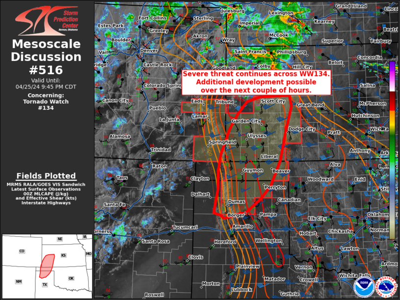
   Mesoscale Discussion 0516
   NWS Storm Prediction Center Norman OK
   0742 PM CDT Thu Apr 25 2024

   Areas affected...northern Texas Panhandle...central Oklahoma
   Panhandle...and southwestern Kansas

   Concerning...Tornado Watch 134...

   Valid 260042Z - 260245Z

   The severe weather threat for Tornado Watch 134 continues.

   SUMMARY...Severe threat continues across WW134. Additional
   thunderstorm development possible over the next couple of hours.

   DISCUSSION...Visible satellite imagery across the Texas/Oklahoma
   Panhandles continues to show areas of towering cumulus clustered
   along the dryline. Thus far, attempts at initiation have been
   unsuccessful. The  00z RAOB from AMA indicates MLCIN has eroded amid
   steep lapse rates throughout the profile. Given the increase
   expected in the low-level jet through the next couple of hours and
   additional synoptic forcing for ascent, further scattered
   thunderstorm development will be possible. Recent CAM guidance
   supports this notion, though there are difference in timing/location
   of initiation within this region. Surface objective analysis
   indicates around 2500-3000 J/kg MLCAPE with deep layer shear at
   50-55 kts. Given initially modest forcing and south-southwesterly
   deep layer flow, storms will initiate along the dryline before
   moving north eastward with the initial threat of large hail and
   damaging winds. Any cells that maintain strength through the evening
   will see an increasing threat for tornadoes as the low-level jet
   increases enlarging hodographs and increasing low-level shear.

   ..Thornton/Edwards.. 04/26/2024

   ...Please see www.spc.noaa.gov for graphic product...

   ATTN...WFO...DDC...GLD...AMA...PUB...

   LAT...LON   36280226 36760226 37170218 37470207 37840191 38240164
               38550134 38680089 38719994 38449986 37700008 37040024
               36360056 36010089 35640140 35650152 35560180 35510206
               35600217 35650240 36280226
|
|
Top/All Mesoscale Discussions/Forecast Products/Home
|
|


 @NWSSPC