 Note:
The expiration time in the watch graphic is amended if the watch is
replaced, cancelled or extended.
Note:
Note:
The expiration time in the watch graphic is amended if the watch is
replaced, cancelled or extended.
Note: Click for
Watch Status Reports.
SEL1
URGENT - IMMEDIATE BROADCAST REQUESTED
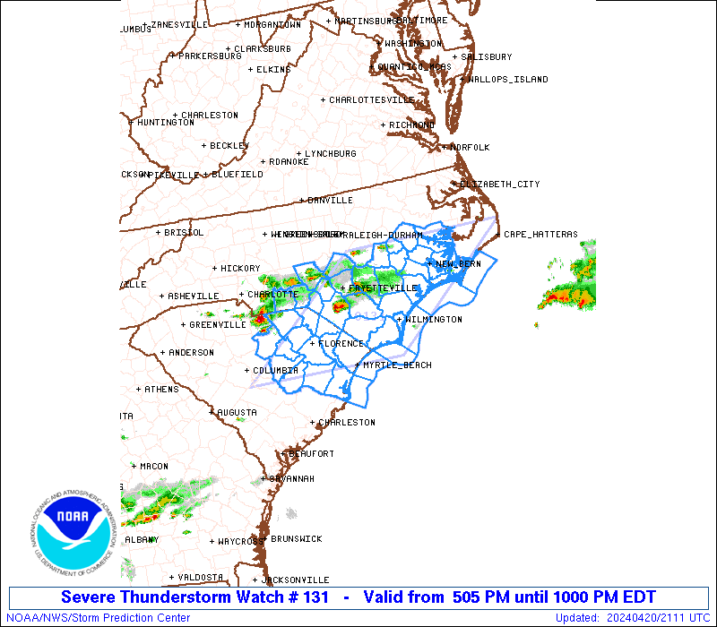
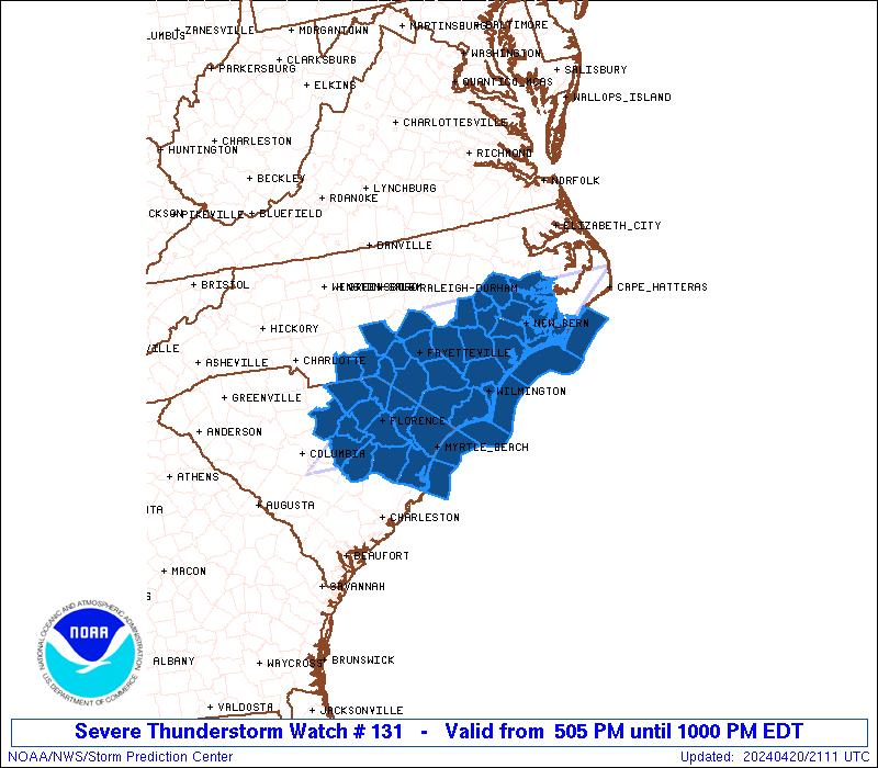
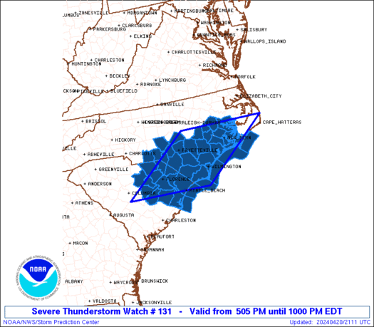
Severe Thunderstorm Watch Number 131
NWS Storm Prediction Center Norman OK
505 PM EDT Sat Apr 20 2024
The NWS Storm Prediction Center has issued a
* Severe Thunderstorm Watch for portions of
parts of southern and eastern North Carolina
part of eastern South Carolina
Coastal Waters
* Effective this Saturday afternoon and evening from 505 PM until
1000 PM EDT.
* Primary threats include...
Scattered large hail and isolated very large hail events to 2
inches in diameter possible
Isolated damaging wind gusts to 65 mph possible
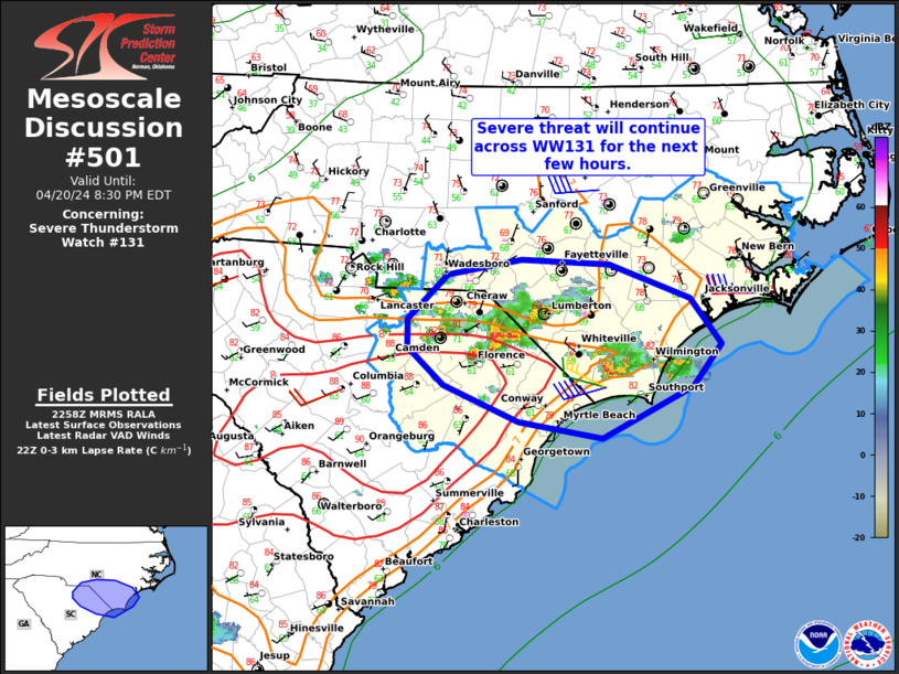
SUMMARY...Widely scattered to scattered strong/severe thunderstorms
are forecast to continue spreading east-southeastward across
portions of the Carolinas this afternoon. Large hail, and locally
damaging wind gusts, can be expected with the most intense storms,
before moving offshore this evening.
The severe thunderstorm watch area is approximately along and 90
statute miles east and west of a line from 35 miles north of New
Bern NC to 35 miles west of Myrtle Beach SC. For a complete
depiction of the watch see the associated watch outline update
(WOUS64 KWNS WOU1).
PRECAUTIONARY/PREPAREDNESS ACTIONS...
REMEMBER...A Severe Thunderstorm Watch means conditions are
favorable for severe thunderstorms in and close to the watch area.
Persons in these areas should be on the lookout for threatening
weather conditions and listen for later statements and possible
warnings. Severe thunderstorms can and occasionally do produce
tornadoes.
&&
AVIATION...A few severe thunderstorms with hail surface and aloft to
2 inches. Extreme turbulence and surface wind gusts to 55 knots. A
few cumulonimbi with maximum tops to 500. Mean storm motion vector
29040.
...Goss

   SEL1

   URGENT - IMMEDIATE BROADCAST REQUESTED
   Severe Thunderstorm Watch Number 131
   NWS Storm Prediction Center Norman OK
   505 PM EDT Sat Apr 20 2024

   The NWS Storm Prediction Center has issued a

   * Severe Thunderstorm Watch for portions of
     parts of southern and eastern North Carolina
     part of eastern South Carolina
     Coastal Waters

   * Effective this Saturday afternoon and evening from 505 PM until
     1000 PM EDT.

   * Primary threats include...
     Scattered large hail and isolated very large hail events to 2
       inches in diameter possible
     Isolated damaging wind gusts to 65 mph possible

   SUMMARY...Widely scattered to scattered strong/severe thunderstorms
   are forecast to continue spreading east-southeastward across
   portions of the Carolinas this afternoon.  Large hail, and locally
   damaging wind gusts, can be expected with the most intense storms,
   before moving offshore this evening.

   The severe thunderstorm watch area is approximately along and 90
   statute miles east and west of a line from 35 miles north of New
   Bern NC to 35 miles west of Myrtle Beach SC. For a complete
   depiction of the watch see the associated watch outline update
   (WOUS64 KWNS WOU1).

   PRECAUTIONARY/PREPAREDNESS ACTIONS...

   REMEMBER...A Severe Thunderstorm Watch means conditions are
   favorable for severe thunderstorms in and close to the watch area.
   Persons in these areas should be on the lookout for threatening
   weather conditions and listen for later statements and possible
   warnings. Severe thunderstorms can and occasionally do produce
   tornadoes.

   &&

   AVIATION...A few severe thunderstorms with hail surface and aloft to
   2 inches. Extreme turbulence and surface wind gusts to 55 knots. A
   few cumulonimbi with maximum tops to 500. Mean storm motion vector
   29040.

   ...Goss
 Note:
The Aviation Watch (SAW) product is an approximation to the watch area.
The actual watch is depicted by the shaded areas.
Note:
The Aviation Watch (SAW) product is an approximation to the watch area.
The actual watch is depicted by the shaded areas.
SAW1
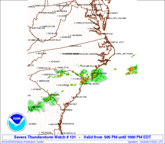
WW 131 SEVERE TSTM NC SC CW 202105Z - 210200Z
AXIS..90 STATUTE MILES EAST AND WEST OF LINE..
35N EWN/NEW BERN NC/ - 35W CRE/MYRTLE BEACH SC/
..AVIATION COORDS.. 80NM E/W /59SW ECG - 34S FLO/
HAIL SURFACE AND ALOFT..2 INCHES. WIND GUSTS..55 KNOTS.
MAX TOPS TO 500. MEAN STORM MOTION VECTOR 29040.
LAT...LON 35577544 33667797 33668110 35577865
THIS IS AN APPROXIMATION TO THE WATCH AREA. FOR A
COMPLETE DEPICTION OF THE WATCH SEE WOUS64 KWNS
FOR WOU1.
Watch 131 Status Report Messages:
STATUS REPORT #3 ON WW 131

VALID 210040Z - 210140Z

SEVERE WEATHER THREAT CONTINUES RIGHT OF A LINE FROM 20 SSE CRE
TO 20 NW FLO TO 35 SSW SOP TO 55 SSE EWN.

..WEINMAN..04/21/24

ATTN...WFO...RAH...MHX...ILM...CAE...

&&

STATUS REPORT FOR WS 131

SEVERE WEATHER THREAT CONTINUES FOR THE FOLLOWING AREAS

NCC017-019-047-129-141-155-210140-

NC
.    NORTH CAROLINA COUNTIES INCLUDED ARE

BLADEN		     BRUNSWICK		 COLUMBUS
NEW HANOVER	     PENDER		 ROBESON
$$


SCC033-043-051-067-069-210140-

SC
.    SOUTH CAROLINA COUNTIES INCLUDED ARE

DILLON		     GEORGETOWN 	 HORRY
MARION		     MARLBORO
$$


AMZ250-252-254-256-210140-

CW

.    ADJACENT COASTAL WATERS INCLUDED ARE

COASTAL WATERS FROM SURF CITY TO CAPE FEAR NC OUT 20 NM

COASTAL WATERS FROM CAPE FEAR NC TO LITTLE RIVER INLET SC OUT 20
NM

COASTAL WATERS FROM LITTLE RIVER INLET TO MURRELLS INLET SC OUT
20 NM

COASTAL WATERS FROM MURRELLS INLET TO SOUTH SANTEE RIVER SC OUT
20 NM

$$
THE WATCH STATUS MESSAGE IS FOR GUIDANCE PURPOSES ONLY.  PLEASE
REFER TO WATCH COUNTY NOTIFICATION STATEMENTS FOR OFFICIAL
INFORMATION ON COUNTIES...INDEPENDENT CITIES AND MARINE ZONES
CLEARED FROM SEVERE THUNDERSTORM AND TORNADO WATCHES.
$$

STATUS REPORT #2 ON WW 131

VALID 202355Z - 210040Z

SEVERE WEATHER THREAT CONTINUES RIGHT OF A LINE FROM 30 WSW SOP
TO 50 SE EWN.

FOR ADDITIONAL INFORMATION SEE MESOSCALE DISCUSSION 501

..WEINMAN..04/20/24

ATTN...WFO...RAH...MHX...ILM...CAE...

&&

STATUS REPORT FOR WS 131

SEVERE WEATHER THREAT CONTINUES FOR THE FOLLOWING AREAS

NCC017-019-047-129-141-155-210040-

NC
.    NORTH CAROLINA COUNTIES INCLUDED ARE

BLADEN		     BRUNSWICK		 COLUMBUS
NEW HANOVER	     PENDER		 ROBESON
$$


SCC025-027-031-033-041-043-051-055-061-067-069-085-089-210040-

SC
.    SOUTH CAROLINA COUNTIES INCLUDED ARE

CHESTERFIELD	     CLARENDON		 DARLINGTON
DILLON		     FLORENCE		 GEORGETOWN
HORRY		     KERSHAW		 LEE
MARION		     MARLBORO		 SUMTER
WILLIAMSBURG
$$


AMZ250-252-254-256-210040-

CW

.    ADJACENT COASTAL WATERS INCLUDED ARE

COASTAL WATERS FROM SURF CITY TO CAPE FEAR NC OUT 20 NM

COASTAL WATERS FROM CAPE FEAR NC TO LITTLE RIVER INLET SC OUT 20
NM

COASTAL WATERS FROM LITTLE RIVER INLET TO MURRELLS INLET SC OUT
20 NM

COASTAL WATERS FROM MURRELLS INLET TO SOUTH SANTEE RIVER SC OUT
20 NM

$$
THE WATCH STATUS MESSAGE IS FOR GUIDANCE PURPOSES ONLY.  PLEASE
REFER TO WATCH COUNTY NOTIFICATION STATEMENTS FOR OFFICIAL
INFORMATION ON COUNTIES...INDEPENDENT CITIES AND MARINE ZONES
CLEARED FROM SEVERE THUNDERSTORM AND TORNADO WATCHES.
$$

STATUS REPORT #1 ON WW 131

VALID 202240Z - 202340Z

THE SEVERE WEATHER THREAT CONTINUES ACROSS THE ENTIRE WATCH AREA.

..WEINMAN..04/20/24

ATTN...WFO...RAH...MHX...ILM...CAE...

&&

STATUS REPORT FOR WS 131

SEVERE WEATHER THREAT CONTINUES FOR THE FOLLOWING AREAS

NCC007-013-017-019-031-047-049-051-061-079-085-093-103-107-125-
129-133-137-141-147-153-155-163-165-191-202340-

NC
.    NORTH CAROLINA COUNTIES INCLUDED ARE

ANSON		     BEAUFORT		 BLADEN
BRUNSWICK	     CARTERET		 COLUMBUS
CRAVEN		     CUMBERLAND 	 DUPLIN
GREENE		     HARNETT		 HOKE
JONES		     LENOIR		 MOORE
NEW HANOVER	     ONSLOW		 PAMLICO
PENDER		     PITT		 RICHMOND
ROBESON 	     SAMPSON		 SCOTLAND
WAYNE
$$


SCC025-027-031-033-041-043-051-055-061-067-069-085-089-202340-

SC
.    SOUTH CAROLINA COUNTIES INCLUDED ARE

CHESTERFIELD	     CLARENDON		 DARLINGTON
DILLON		     FLORENCE		 GEORGETOWN
HORRY		     KERSHAW		 LEE
MARION		     MARLBORO		 SUMTER
WILLIAMSBURG
$$


AMZ136-137-156-158-250-252-254-256-202340-

CW

.    ADJACENT COASTAL WATERS INCLUDED ARE

PAMLICO AND PUNGO RIVERS

NEUSE AND BAY RIVERS

S OF OCRACOKE INLET NC TO CAPE LOOKOUT NC OUT TO 20 NM

S OF CAPE LOOKOUT NC TO SURF CITY NC OUT TO 20 NM

COASTAL WATERS FROM SURF CITY TO CAPE FEAR NC OUT 20 NM

COASTAL WATERS FROM CAPE FEAR NC TO LITTLE RIVER INLET SC OUT 20
NM

COASTAL WATERS FROM LITTLE RIVER INLET TO MURRELLS INLET SC OUT
20 NM

COASTAL WATERS FROM MURRELLS INLET TO SOUTH SANTEE RIVER SC OUT
20 NM

$$
THE WATCH STATUS MESSAGE IS FOR GUIDANCE PURPOSES ONLY.  PLEASE
REFER TO WATCH COUNTY NOTIFICATION STATEMENTS FOR OFFICIAL
INFORMATION ON COUNTIES...INDEPENDENT CITIES AND MARINE ZONES
CLEARED FROM SEVERE THUNDERSTORM AND TORNADO WATCHES.
$$
Note:
Click for Complete Product Text.
Tornadoes
Probability of 2 or more tornadoes
|
Low (<5%)
|
Probability of 1 or more strong (EF2-EF5) tornadoes
|
Low (<2%)
|
Wind
Probability of 10 or more severe wind events
|
Low (20%)
|
Probability of 1 or more wind events > 65 knots
|
Low (10%)
|
Hail
Probability of 10 or more severe hail events
|
Mod (50%)
|
Probability of 1 or more hailstones > 2 inches
|
Mod (30%)
|
Combined Severe Hail/Wind
Probability of 6 or more combined severe hail/wind events
|
High (80%)
|
For each watch, probabilities for particular events inside the watch
(listed above in each table) are determined by the issuing forecaster.
The "Low" category contains probability values ranging from less than 2%
to 20% (EF2-EF5 tornadoes), less than 5% to 20% (all other probabilities),
"Moderate" from 30% to 60%, and "High" from 70% to greater than 95%.
High values are bolded and lighter in color to provide awareness of
an increased threat for a particular event.


 @NWSSPC