 Note:
The expiration time in the watch graphic is amended if the watch is
replaced, cancelled or extended.
Note:
Note:
The expiration time in the watch graphic is amended if the watch is
replaced, cancelled or extended.
Note: Click for
Watch Status Reports.
SEL2
URGENT - IMMEDIATE BROADCAST REQUESTED
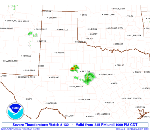
Severe Thunderstorm Watch Number 132
NWS Storm Prediction Center Norman OK
345 PM CDT Tue Apr 23 2024
The NWS Storm Prediction Center has issued a
* Severe Thunderstorm Watch for portions of
Northwest Texas
* Effective this Tuesday afternoon and evening from 345 PM until
1000 PM CDT.
* Primary threats include...
Scattered large hail and isolated very large hail events to 2.5
inches in diameter possible
Scattered damaging wind gusts to 70 mph possible
SUMMARY...Isolated to scattered thunderstorms are forecast to
develop this afternoon into the evening. A few of the stronger
storms will probably evolve into supercells and pose a risk for
large to very large hail and severe gusts.
The severe thunderstorm watch area is approximately along and 60
statute miles north and south of a line from 95 miles west northwest
of Abilene TX to 75 miles east northeast of Abilene TX. For a
complete depiction of the watch see the associated watch outline
update (WOUS64 KWNS WOU2).
PRECAUTIONARY/PREPAREDNESS ACTIONS...
REMEMBER...A Severe Thunderstorm Watch means conditions are
favorable for severe thunderstorms in and close to the watch area.
Persons in these areas should be on the lookout for threatening
weather conditions and listen for later statements and possible
warnings. Severe thunderstorms can and occasionally do produce
tornadoes.
&&
AVIATION...A few severe thunderstorms with hail surface and aloft to
2.5 inches. Extreme turbulence and surface wind gusts to 60 knots. A
few cumulonimbi with maximum tops to 450. Mean storm motion vector
27030.
...Smith
 Note:
The Aviation Watch (SAW) product is an approximation to the watch area.
The actual watch is depicted by the shaded areas.
Note:
The Aviation Watch (SAW) product is an approximation to the watch area.
The actual watch is depicted by the shaded areas.
SAW2
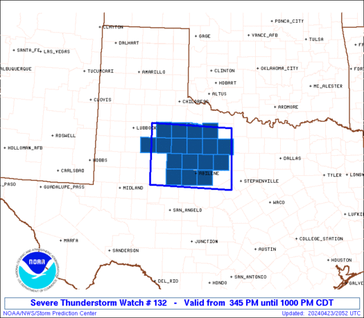
WW 132 SEVERE TSTM TX 232045Z - 240300Z
AXIS..60 STATUTE MILES NORTH AND SOUTH OF LINE..
95WNW ABI/ABILENE TX/ - 75ENE ABI/ABILENE TX/
..AVIATION COORDS.. 50NM N/S /59SE LBB - 70S SPS/
HAIL SURFACE AND ALOFT..2.5 INCHES. WIND GUSTS..60 KNOTS.
MAX TOPS TO 450. MEAN STORM MOTION VECTOR 27030.
LAT...LON 33810119 33709849 31969849 32070119
THIS IS AN APPROXIMATION TO THE WATCH AREA. FOR A
COMPLETE DEPICTION OF THE WATCH SEE WOUS64 KWNS
FOR WOU2.
Watch 132 Status Report Messages:
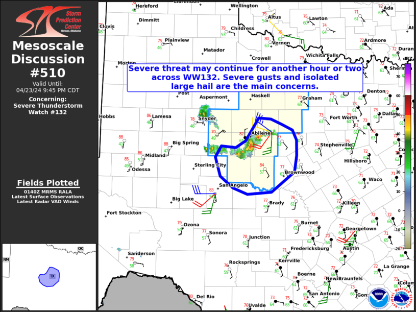
STATUS REPORT #4 ON WW 132

VALID 240150Z - 240240Z

SEVERE WEATHER THREAT CONTINUES RIGHT OF A LINE FROM 10 S BGS TO
20 WNW ABI TO 5 WNW MWL.

FOR ADDITIONAL INFORMATION SEE MESOSCALE DISCUSSION 510

..WEINMAN..04/24/24

ATTN...WFO...OUN...SJT...LUB...FWD...

&&

STATUS REPORT FOR WS 132

SEVERE WEATHER THREAT CONTINUES FOR THE FOLLOWING AREAS

TXC059-083-353-399-417-429-441-240240-

TX
.    TEXAS COUNTIES INCLUDED ARE

CALLAHAN	     COLEMAN		 NOLAN
RUNNELS 	     SHACKELFORD	 STEPHENS
TAYLOR
$$


THE WATCH STATUS MESSAGE IS FOR GUIDANCE PURPOSES ONLY.  PLEASE
REFER TO WATCH COUNTY NOTIFICATION STATEMENTS FOR OFFICIAL
INFORMATION ON COUNTIES...INDEPENDENT CITIES AND MARINE ZONES
CLEARED FROM SEVERE THUNDERSTORM AND TORNADO WATCHES.
$$

STATUS REPORT #3 ON WW 132

VALID 240040Z - 240140Z

SEVERE WEATHER THREAT CONTINUES RIGHT OF A LINE FROM 50 N BGS TO
10 NNE MWL.

FOR ADDITIONAL INFORMATION SEE MESOSCALE DISCUSSION 509

..WEINMAN..04/24/24

ATTN...WFO...OUN...SJT...LUB...FWD...

&&

STATUS REPORT FOR WS 132

SEVERE WEATHER THREAT CONTINUES FOR THE FOLLOWING AREAS

TXC059-151-253-353-417-429-441-240140-

TX
.    TEXAS COUNTIES INCLUDED ARE

CALLAHAN	     FISHER		 JONES
NOLAN		     SHACKELFORD	 STEPHENS
TAYLOR
$$


THE WATCH STATUS MESSAGE IS FOR GUIDANCE PURPOSES ONLY.  PLEASE
REFER TO WATCH COUNTY NOTIFICATION STATEMENTS FOR OFFICIAL
INFORMATION ON COUNTIES...INDEPENDENT CITIES AND MARINE ZONES
CLEARED FROM SEVERE THUNDERSTORM AND TORNADO WATCHES.
$$

STATUS REPORT #2 ON WW 132

VALID 232355Z - 240040Z

SEVERE WEATHER THREAT CONTINUES RIGHT OF A LINE FROM 25 SE LBB TO
40 N MWL.

FOR ADDITIONAL INFORMATION SEE MESOSCALE DISCUSSION 509

..WEINMAN..04/23/24

ATTN...WFO...OUN...SJT...LUB...FWD...

&&

STATUS REPORT FOR WS 132

SEVERE WEATHER THREAT CONTINUES FOR THE FOLLOWING AREAS

TXC059-151-169-207-253-263-353-417-429-433-441-447-503-240040-

TX
.    TEXAS COUNTIES INCLUDED ARE

CALLAHAN	     FISHER		 GARZA
HASKELL 	     JONES		 KENT
NOLAN		     SHACKELFORD	 STEPHENS
STONEWALL	     TAYLOR		 THROCKMORTON
YOUNG
$$


THE WATCH STATUS MESSAGE IS FOR GUIDANCE PURPOSES ONLY.  PLEASE
REFER TO WATCH COUNTY NOTIFICATION STATEMENTS FOR OFFICIAL
INFORMATION ON COUNTIES...INDEPENDENT CITIES AND MARINE ZONES
CLEARED FROM SEVERE THUNDERSTORM AND TORNADO WATCHES.
$$

STATUS REPORT #1 ON WW 132

VALID 232145Z - 232240Z

THE SEVERE WEATHER THREAT CONTINUES ACROSS THE ENTIRE WATCH AREA.

..WEINMAN..04/23/24

ATTN...WFO...OUN...SJT...LUB...FWD...

&&

STATUS REPORT FOR WS 132

SEVERE WEATHER THREAT CONTINUES FOR THE FOLLOWING AREAS

TXC023-059-125-151-169-207-253-263-269-275-353-417-429-433-441-
447-503-232240-

TX
.    TEXAS COUNTIES INCLUDED ARE

BAYLOR		     CALLAHAN		 DICKENS
FISHER		     GARZA		 HASKELL
JONES		     KENT		 KING
KNOX		     NOLAN		 SHACKELFORD
STEPHENS	     STONEWALL		 TAYLOR
THROCKMORTON	     YOUNG
$$


THE WATCH STATUS MESSAGE IS FOR GUIDANCE PURPOSES ONLY.  PLEASE
REFER TO WATCH COUNTY NOTIFICATION STATEMENTS FOR OFFICIAL
INFORMATION ON COUNTIES...INDEPENDENT CITIES AND MARINE ZONES
CLEARED FROM SEVERE THUNDERSTORM AND TORNADO WATCHES.
$$
Note:
Click for Complete Product Text.
Tornadoes
Probability of 2 or more tornadoes
|
Low (<5%)
|
Probability of 1 or more strong (EF2-EF5) tornadoes
|
Low (<2%)
|
Wind
Probability of 10 or more severe wind events
|
Mod (40%)
|
Probability of 1 or more wind events > 65 knots
|
Low (20%)
|
Hail
Probability of 10 or more severe hail events
|
Mod (40%)
|
Probability of 1 or more hailstones > 2 inches
|
Mod (40%)
|
Combined Severe Hail/Wind
Probability of 6 or more combined severe hail/wind events
|
High (70%)
|
For each watch, probabilities for particular events inside the watch
(listed above in each table) are determined by the issuing forecaster.
The "Low" category contains probability values ranging from less than 2%
to 20% (EF2-EF5 tornadoes), less than 5% to 20% (all other probabilities),
"Moderate" from 30% to 60%, and "High" from 70% to greater than 95%.
High values are bolded and lighter in color to provide awareness of
an increased threat for a particular event.


 @NWSSPC