|
| Mesoscale Discussion 501 |
|
< Previous MD Next MD >
|
|
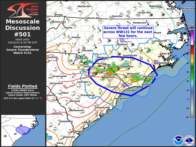
   Mesoscale Discussion 0501
   NWS Storm Prediction Center Norman OK
   0600 PM CDT Sat Apr 20 2024

   Areas affected...Portions of southeastern NC and northeastern SC

   Concerning...Severe Thunderstorm Watch 131...

   Valid 202300Z - 210030Z

   The severe weather threat for Severe Thunderstorm Watch 131
   continues.

   SUMMARY...The severe risk will continue across Severe Thunderstorm
   Watch 131 for the next few hours. Primary concerns are isolated
   large hail and locally damaging gusts.

   DISCUSSION...Two main corridors of severe storms persist across
   portions of southeastern NC and northeastern SC this evening. Closer
   to the southeastern NC coast, recent storm mergers have yielded a
   consolidated supercell which is generally anchored to an
   outflow-modified sea breeze boundary. This storm will likely
   continue drifting slowly south-southeastward to the coast, with a
   risk of locally damaging gusts (50-65 mph) and isolated large hail
   (up to 1.5 inches in diameter). Slightly farther northwest (over the
   northeastern SC/southeastern NC border), splitting storms with
   occasional supercell structure are ongoing amid a long/straight
   hodograph environment and moderate surface-based instability. These
   storms will continue to pose a risk of isolated large hail as well,
   in addition to severe gusts given a steep low-level lapse rate plume
   extending toward the inflow of this activity. The severe threat will
   generally persist until storms move off the coast in the next 3-4
   hours.

   ..Weinman.. 04/20/2024

   ...Please see www.spc.noaa.gov for graphic product...

   ATTN...WFO...MHX...RAH...ILM...CAE...

   LAT...LON   33557845 33697931 33998009 34318045 34568046 34938005
               35077928 35027839 34737755 34347724 33997752 33557845
|
|
Top/All Mesoscale Discussions/Forecast Products/Home
|
|


 @NWSSPC