 Note:
The expiration time in the watch graphic is amended if the watch is
replaced, cancelled or extended.
Note:
Note:
The expiration time in the watch graphic is amended if the watch is
replaced, cancelled or extended.
Note: Click for
Watch Status Reports.
SEL5
URGENT - IMMEDIATE BROADCAST REQUESTED
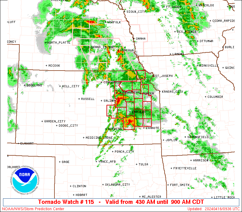
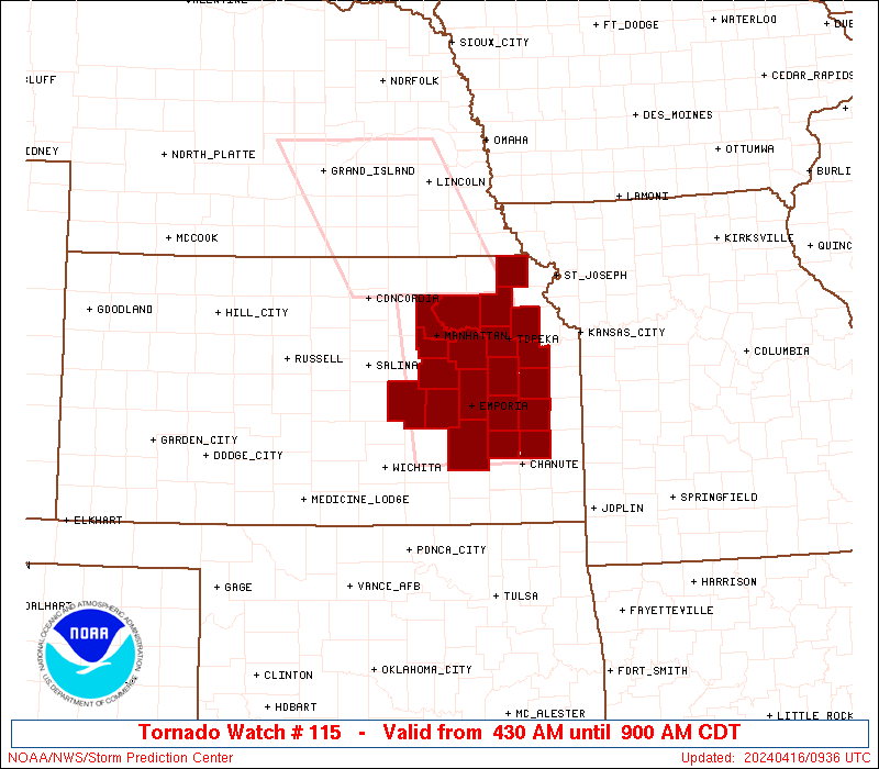
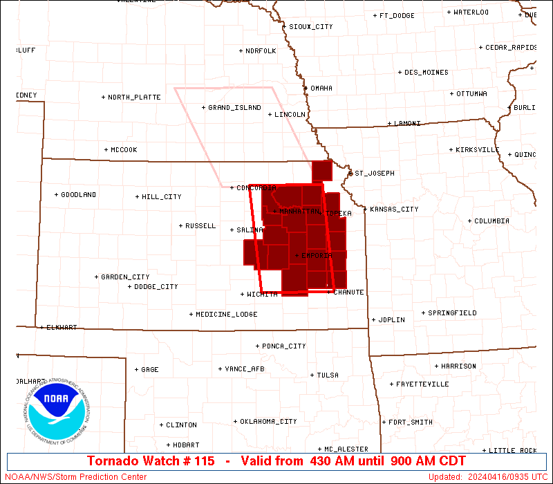
Tornado Watch Number 115
NWS Storm Prediction Center Norman OK
430 AM CDT Tue Apr 16 2024
The NWS Storm Prediction Center has issued a
* Tornado Watch for portions of
Eastern Kansas
* Effective this Tuesday morning from 430 AM until 900 AM CDT.
* Primary threats include...
A few tornadoes and a couple intense tornadoes possible
Scattered large hail and isolated very large hail events to 2
inches in diameter possible
Isolated damaging wind gusts to 70 mph possible
SUMMARY...Supercells capable of producing all severe hazards will
move eastward this morning.
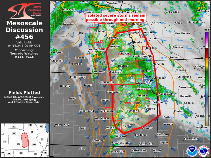
The tornado watch area is approximately along and 45 statute miles
east and west of a line from 35 miles north northeast of Manhattan
KS to 45 miles south of Emporia KS. For a complete depiction of the
watch see the associated watch outline update (WOUS64 KWNS WOU5).
PRECAUTIONARY/PREPAREDNESS ACTIONS...
REMEMBER...A Tornado Watch means conditions are favorable for
tornadoes and severe thunderstorms in and close to the watch
area. Persons in these areas should be on the lookout for
threatening weather conditions and listen for later statements
and possible warnings.
&&
OTHER WATCH INFORMATION...CONTINUE...WW 114...
AVIATION...Tornadoes and a few severe thunderstorms with hail
surface and aloft to 2 inches. Extreme turbulence and surface wind
gusts to 60 knots. A few cumulonimbi with maximum tops to 500. Mean
storm motion vector 22035.
...Gleason
 Note:
The Aviation Watch (SAW) product is an approximation to the watch area.
The actual watch is depicted by the shaded areas.
Note:
The Aviation Watch (SAW) product is an approximation to the watch area.
The actual watch is depicted by the shaded areas.
   SAW5
   WW 115 TORNADO KS 160930Z - 161400Z
   AXIS..45 STATUTE MILES EAST AND WEST OF LINE..
   35NNE MHK/MANHATTAN KS/ - 45S EMP/EMPORIA KS/
   ..AVIATION COORDS.. 40NM E/W /37SSW PWE - 57NW OSW/
   HAIL SURFACE AND ALOFT..2 INCHES. WIND GUSTS..60 KNOTS.
   MAX TOPS TO 500. MEAN STORM MOTION VECTOR 22035.

   LAT...LON 39599557 37689536 37689700 39599726

   THIS IS AN APPROXIMATION TO THE WATCH AREA.  FOR A
   COMPLETE DEPICTION OF THE WATCH SEE WOUS64 KWNS
   FOR WOU5.
Watch 115 Status Report Messages:
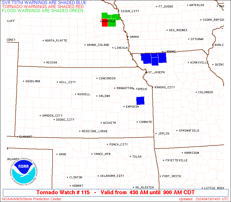
STATUS REPORT #3 ON WW 115

VALID 161230Z - 161340Z

SEVERE WEATHER THREAT CONTINUES RIGHT OF A LINE FROM 45 SSW EMP
TO 40 SSW FNB.

FOR ADDITIONAL INFORMATION SEE MESOSCALE DISCUSSION 456.

..GRAMS..04/16/24

ATTN...WFO...ICT...TOP...

&&

STATUS REPORT FOR WT 115

SEVERE WEATHER THREAT CONTINUES FOR THE FOLLOWING AREAS

KSC001-003-013-031-045-059-073-085-087-111-139-177-197-207-
161340-

KS
.    KANSAS COUNTIES INCLUDED ARE

ALLEN		     ANDERSON		 BROWN
COFFEY		     DOUGLAS		 FRANKLIN
GREENWOOD	     JACKSON		 JEFFERSON
LYON		     OSAGE		 SHAWNEE
WABAUNSEE	     WOODSON
$$


THE WATCH STATUS MESSAGE IS FOR GUIDANCE PURPOSES ONLY.  PLEASE
REFER TO WATCH COUNTY NOTIFICATION STATEMENTS FOR OFFICIAL
INFORMATION ON COUNTIES...INDEPENDENT CITIES AND MARINE ZONES
CLEARED FROM SEVERE THUNDERSTORM AND TORNADO WATCHES.
$$

STATUS REPORT #2 ON WW 115

VALID 161140Z - 161240Z

SEVERE WEATHER THREAT CONTINUES RIGHT OF A LINE FROM 25 E ICT TO
30 S MHK TO 40 NE MHK.

FOR ADDITIONAL INFORMATION SEE MESOSCALE DISCUSSION 456.

..GRAMS..04/16/24

ATTN...WFO...ICT...TOP...

&&

STATUS REPORT FOR WT 115

SEVERE WEATHER THREAT CONTINUES FOR THE FOLLOWING AREAS

KSC001-003-013-017-031-045-059-073-085-087-111-139-149-177-197-
207-161240-

KS
.    KANSAS COUNTIES INCLUDED ARE

ALLEN		     ANDERSON		 BROWN
CHASE		     COFFEY		 DOUGLAS
FRANKLIN	     GREENWOOD		 JACKSON
JEFFERSON	     LYON		 OSAGE
POTTAWATOMIE	     SHAWNEE		 WABAUNSEE
WOODSON
$$


THE WATCH STATUS MESSAGE IS FOR GUIDANCE PURPOSES ONLY.  PLEASE
REFER TO WATCH COUNTY NOTIFICATION STATEMENTS FOR OFFICIAL
INFORMATION ON COUNTIES...INDEPENDENT CITIES AND MARINE ZONES
CLEARED FROM SEVERE THUNDERSTORM AND TORNADO WATCHES.
$$

STATUS REPORT #1 ON WW 115

VALID 161025Z - 161140Z

SEVERE WEATHER THREAT CONTINUES RIGHT OF A LINE FROM 30 NE ICT TO
20 SW MHK TO 35 E CNK.

..GRAMS..04/16/24

ATTN...WFO...ICT...TOP...

&&

STATUS REPORT FOR WT 115

SEVERE WEATHER THREAT CONTINUES FOR THE FOLLOWING AREAS

KSC001-003-013-017-031-045-059-061-073-085-087-111-127-139-149-
161-177-197-207-161140-

KS
.    KANSAS COUNTIES INCLUDED ARE

ALLEN		     ANDERSON		 BROWN
CHASE		     COFFEY		 DOUGLAS
FRANKLIN	     GEARY		 GREENWOOD
JACKSON 	     JEFFERSON		 LYON
MORRIS		     OSAGE		 POTTAWATOMIE
RILEY		     SHAWNEE		 WABAUNSEE
WOODSON
$$


THE WATCH STATUS MESSAGE IS FOR GUIDANCE PURPOSES ONLY.  PLEASE
REFER TO WATCH COUNTY NOTIFICATION STATEMENTS FOR OFFICIAL
INFORMATION ON COUNTIES...INDEPENDENT CITIES AND MARINE ZONES
CLEARED FROM SEVERE THUNDERSTORM AND TORNADO WATCHES.
$$
Note:
Click for Complete Product Text.
Tornadoes
Probability of 2 or more tornadoes
|
Mod (50%)
|
Probability of 1 or more strong (EF2-EF5) tornadoes
|
Mod (30%)
|
Wind
Probability of 10 or more severe wind events
|
Mod (30%)
|
Probability of 1 or more wind events > 65 knots
|
Low (10%)
|
Hail
Probability of 10 or more severe hail events
|
Mod (40%)
|
Probability of 1 or more hailstones > 2 inches
|
Mod (30%)
|
Combined Severe Hail/Wind
Probability of 6 or more combined severe hail/wind events
|
Mod (60%)
|
For each watch, probabilities for particular events inside the watch
(listed above in each table) are determined by the issuing forecaster.
The "Low" category contains probability values ranging from less than 2%
to 20% (EF2-EF5 tornadoes), less than 5% to 20% (all other probabilities),
"Moderate" from 30% to 60%, and "High" from 70% to greater than 95%.
High values are bolded and lighter in color to provide awareness of
an increased threat for a particular event.


 @NWSSPC