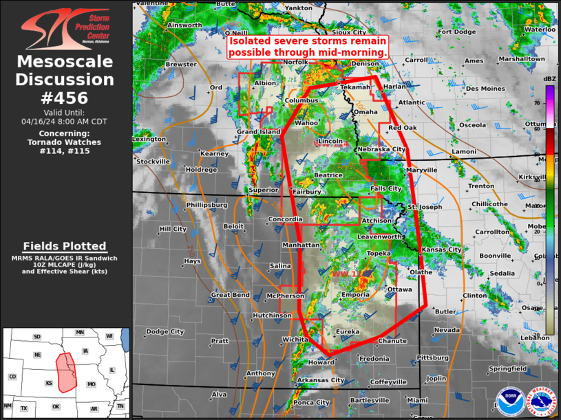
   Mesoscale Discussion 0456
   NWS Storm Prediction Center Norman OK
   0600 AM CDT Tue Apr 16 2024

   Areas affected...Eastern KS...southeast NE...southwest IA...far
   western MO

   Concerning...Tornado Watch 114...115...

   Valid 161100Z - 161300Z

   The severe weather threat for Tornado Watch 114, 115 continues.

   SUMMARY...Isolated severe storms will remain possible through
   mid-morning within WWs 114-115, with the greatest tornado threat
   over east-central KS. Very isolated severe may also spread east of
   the watches into parts of southwest IA and far western MO.

   DISCUSSION...Over eastern KS, the only well-developed supercell that
   earlier produced a tornado in Greenwood County, KS appeared to have
   weaken for a period before restrengthening again as other cells
   around it diminished. Given the history of this supercell, another
   tornadogenesis cycle appears to be underway over east-central KS
   given the mid 60s surface dew points and relative lack of
   potentially destructive interference amid 0-1 km shear of 40-45 kts.
   How long this process can last is uncertain given somewhat less
   favorable thermodynamics downstream over the MO River. But should a
   long-track supercell persist, it is plausible that a small
   additional watch may be needed.

   Across NE, the overall severe threat has become more nebulous after
   the decay of the severe-producing QLCS over north-central
   KS/south-central NE earlier this morning. Remnant deep convection is
   still ongoing across parts of eastern NE with renewed development
   just southeast of the 990-mb surface cyclone in south-central NE.
   Instability within much of this portion of the warm sector appears
   to be subsiding, especially with pervasive convection across eastern
   KS. Still, isolated severe wind gusts, a brief tornado, and
   marginally severe hail will remain possible for a few more hours.

   ..Grams/Gleason.. 04/16/2024

   ...Please see www.spc.noaa.gov for graphic product...

   ATTN...WFO...SGF...DMX...EAX...OAX...TOP...ICT...GID...

   LAT...LON   41699681 41879545 40739481 39229458 38299448 37819538
               37539639 37819683 38229699 39279699 40949739 41699681
|


 @NWSSPC