 Note:
The expiration time in the watch graphic is amended if the watch is
replaced, cancelled or extended.
Note:
Note:
The expiration time in the watch graphic is amended if the watch is
replaced, cancelled or extended.
Note: Click for
Watch Status Reports.
SEL6
URGENT - IMMEDIATE BROADCAST REQUESTED
Tornado Watch Number 116
NWS Storm Prediction Center Norman OK
1020 AM CDT Tue Apr 16 2024
The NWS Storm Prediction Center has issued a
* Tornado Watch for portions of
Southern Iowa
Western and Northern Missouri
* Effective this Tuesday morning and evening from 1020 AM until
600 PM CDT.
* Primary threats include...
A few tornadoes and a couple intense tornadoes possible
Scattered large hail and isolated very large hail events to 2
inches in diameter possible
Scattered damaging wind gusts to 70 mph possible
SUMMARY...Storms will likely continue to intensify and organize,
including supercells, as they further develop and move northeastward
across the region today, with steady destabilization into afternoon
as heating occurs and cloud breaks occur.
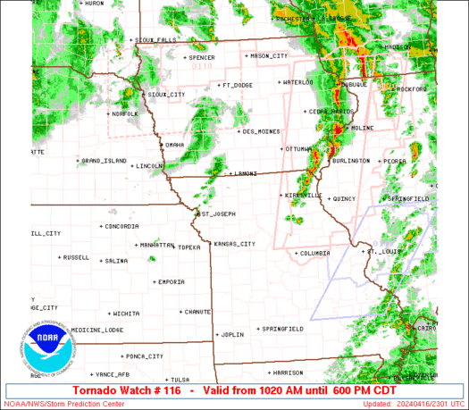
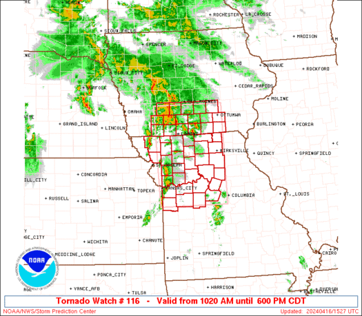
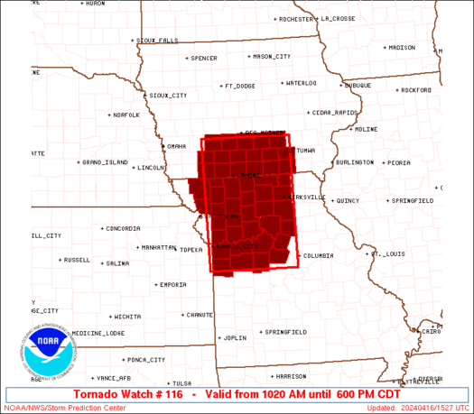
The tornado watch area is approximately along and 65 statute miles
east and west of a line from 25 miles west northwest of Knoxville IA
to 10 miles south southeast of Knob Noster MO. For a complete
depiction of the watch see the associated watch outline update
(WOUS64 KWNS WOU6).
PRECAUTIONARY/PREPAREDNESS ACTIONS...
REMEMBER...A Tornado Watch means conditions are favorable for
tornadoes and severe thunderstorms in and close to the watch
area. Persons in these areas should be on the lookout for
threatening weather conditions and listen for later statements
and possible warnings.
&&
AVIATION...Tornadoes and a few severe thunderstorms with hail
surface and aloft to 2 inches. Extreme turbulence and surface wind
gusts to 60 knots. A few cumulonimbi with maximum tops to 500. Mean
storm motion vector 23040.
...Guyer
   SEL6

   URGENT - IMMEDIATE BROADCAST REQUESTED
   Tornado Watch Number 116
   NWS Storm Prediction Center Norman OK
   1020 AM CDT Tue Apr 16 2024

   The NWS Storm Prediction Center has issued a

   * Tornado Watch for portions of
     Southern Iowa
     Western and Northern Missouri

   * Effective this Tuesday morning and evening from 1020 AM until
     600 PM CDT.

   * Primary threats include...
     A few tornadoes and a couple intense tornadoes possible
     Scattered large hail and isolated very large hail events to 2
       inches in diameter possible
     Scattered damaging wind gusts to 70 mph possible

   SUMMARY...Storms will likely continue to intensify and organize,
   including supercells, as they further develop and move northeastward
   across the region today, with steady destabilization into afternoon
   as heating occurs and cloud breaks occur.

   The tornado watch area is approximately along and 65 statute miles
   east and west of a line from 25 miles west northwest of Knoxville IA
   to 10 miles south southeast of Knob Noster MO. For a complete
   depiction of the watch see the associated watch outline update
   (WOUS64 KWNS WOU6).

   PRECAUTIONARY/PREPAREDNESS ACTIONS...

   REMEMBER...A Tornado Watch means conditions are favorable for
   tornadoes and severe thunderstorms in and close to the watch
   area. Persons in these areas should be on the lookout for
   threatening weather conditions and listen for later statements
   and possible warnings.

   &&

   AVIATION...Tornadoes and a few severe thunderstorms with hail
   surface and aloft to 2 inches. Extreme turbulence and surface wind
   gusts to 60 knots. A few cumulonimbi with maximum tops to 500. Mean
   storm motion vector 23040.

   ...Guyer
 Note:
The Aviation Watch (SAW) product is an approximation to the watch area.
The actual watch is depicted by the shaded areas.
Note:
The Aviation Watch (SAW) product is an approximation to the watch area.
The actual watch is depicted by the shaded areas.
   SAW6
   WW 116 TORNADO IA MO 161520Z - 162300Z
   AXIS..65 STATUTE MILES EAST AND WEST OF LINE..
   25WNW OXV/KNOXVILLE IA/ - 10SSE SZL/KNOB NOSTER MO/
   ..AVIATION COORDS.. 55NM E/W /4E DSM - 51ENE BUM/
   HAIL SURFACE AND ALOFT..2 INCHES. WIND GUSTS..60 KNOTS.
   MAX TOPS TO 500. MEAN STORM MOTION VECTOR 23040.

   LAT...LON 41439231 38589228 38589468 41439482

   THIS IS AN APPROXIMATION TO THE WATCH AREA.  FOR A
   COMPLETE DEPICTION OF THE WATCH SEE WOUS64 KWNS
   FOR WOU6.
Watch 116 Status Report Messages:
STATUS REPORT #4 ON WW 116

VALID 162020Z - 162140Z

SEVERE WEATHER THREAT CONTINUES RIGHT OF A LINE FROM 30 ESE SZL
TO 45 SW OTM TO 20 W DSM.

..LEITMAN..04/16/24

ATTN...WFO...DMX...EAX...

&&

STATUS REPORT FOR WT 116

SEVERE WEATHER THREAT CONTINUES FOR THE FOLLOWING AREAS

IAC007-013-015-017-023-033-049-051-069-075-079-083-099-117-123-
125-127-135-153-157-169-171-179-181-197-162140-

IA
.    IOWA COUNTIES INCLUDED ARE

APPANOOSE	     BLACK HAWK 	 BOONE
BREMER		     BUTLER		 CERRO GORDO
DALLAS		     DAVIS		 FRANKLIN
GRUNDY		     HAMILTON		 HARDIN
JASPER		     LUCAS		 MAHASKA
MARION		     MARSHALL		 MONROE
POLK		     POWESHIEK		 STORY
TAMA		     WAPELLO		 WARREN
WRIGHT
$$


MOC001-041-053-089-121-175-197-162140-

MO
.    MISSOURI COUNTIES INCLUDED ARE

ADAIR		     CHARITON		 COOPER
HOWARD		     MACON		 RANDOLPH
SCHUYLER
$$


THE WATCH STATUS MESSAGE IS FOR GUIDANCE PURPOSES ONLY.  PLEASE
REFER TO WATCH COUNTY NOTIFICATION STATEMENTS FOR OFFICIAL
INFORMATION ON COUNTIES...INDEPENDENT CITIES AND MARINE ZONES
CLEARED FROM SEVERE THUNDERSTORM AND TORNADO WATCHES.
$$

STATUS REPORT #3 ON WW 116

VALID 161935Z - 162040Z

SEVERE WEATHER THREAT CONTINUES RIGHT OF A LINE FROM 15 S SZL TO
25 E LWD TO 50 W DSM.

FOR ADDITIONAL INFORMATION SEE MESOSCALE DISCUSSION 460.

..LEITMAN..04/16/24

ATTN...WFO...DMX...EAX...

&&

STATUS REPORT FOR WT 116

SEVERE WEATHER THREAT CONTINUES FOR THE FOLLOWING AREAS

IAC007-013-015-017-023-033-039-049-051-069-075-079-083-099-117-
121-123-125-127-135-153-157-169-171-179-181-185-197-162040-

IA
.    IOWA COUNTIES INCLUDED ARE

APPANOOSE	     BLACK HAWK 	 BOONE
BREMER		     BUTLER		 CERRO GORDO
CLARKE		     DALLAS		 DAVIS
FRANKLIN	     GRUNDY		 HAMILTON
HARDIN		     JASPER		 LUCAS
MADISON 	     MAHASKA		 MARION
MARSHALL	     MONROE		 POLK
POWESHIEK	     STORY		 TAMA
WAPELLO 	     WARREN		 WAYNE
WRIGHT
$$


MOC001-041-053-089-115-121-159-171-175-195-197-211-162040-

MO
.    MISSOURI COUNTIES INCLUDED ARE

ADAIR		     CHARITON		 COOPER
HOWARD		     LINN		 MACON
PETTIS		     PUTNAM		 RANDOLPH
SALINE		     SCHUYLER		 SULLIVAN
$$


THE WATCH STATUS MESSAGE IS FOR GUIDANCE PURPOSES ONLY.  PLEASE
REFER TO WATCH COUNTY NOTIFICATION STATEMENTS FOR OFFICIAL
INFORMATION ON COUNTIES...INDEPENDENT CITIES AND MARINE ZONES
CLEARED FROM SEVERE THUNDERSTORM AND TORNADO WATCHES.
$$

STATUS REPORT #2 ON WW 116

VALID 161830Z - 161940Z

SEVERE WEATHER THREAT CONTINUES RIGHT OF A LINE FROM 15 SSE STJ
TO 35 NW CDJ TO 20 NW LWD TO 45 SE DNS.

..LEITMAN..04/16/24

ATTN...WFO...DMX...EAX...

&&

STATUS REPORT FOR WT 116

SEVERE WEATHER THREAT CONTINUES FOR THE FOLLOWING AREAS

IAC001-007-013-015-017-023-033-039-049-051-053-069-075-079-083-
099-117-121-123-125-127-135-153-157-159-169-171-175-179-181-185-
197-161940-

IA
.    IOWA COUNTIES INCLUDED ARE

ADAIR		     APPANOOSE		 BLACK HAWK
BOONE		     BREMER		 BUTLER
CERRO GORDO	     CLARKE		 DALLAS
DAVIS		     DECATUR		 FRANKLIN
GRUNDY		     HAMILTON		 HARDIN
JASPER		     LUCAS		 MADISON
MAHASKA 	     MARION		 MARSHALL
MONROE		     POLK		 POWESHIEK
RINGGOLD	     STORY		 TAMA
UNION		     WAPELLO		 WARREN
WAYNE		     WRIGHT
$$


MOC001-025-033-037-041-047-049-053-061-063-079-081-089-095-101-
107-115-117-121-129-159-171-175-177-195-197-211-161940-

MO
.    MISSOURI COUNTIES INCLUDED ARE

ADAIR		     CALDWELL		 CARROLL
CASS		     CHARITON		 CLAY
CLINTON 	     COOPER		 DAVIESS
DEKALB		     GRUNDY		 HARRISON
HOWARD		     JACKSON		 JOHNSON
LAFAYETTE	     LINN		 LIVINGSTON
MACON		     MERCER		 PETTIS
PUTNAM		     RANDOLPH		 RAY
SALINE		     SCHUYLER		 SULLIVAN
$$


THE WATCH STATUS MESSAGE IS FOR GUIDANCE PURPOSES ONLY.  PLEASE
REFER TO WATCH COUNTY NOTIFICATION STATEMENTS FOR OFFICIAL
INFORMATION ON COUNTIES...INDEPENDENT CITIES AND MARINE ZONES
CLEARED FROM SEVERE THUNDERSTORM AND TORNADO WATCHES.
$$

STATUS REPORT #1 ON WW 116

VALID 161650Z - 161740Z

THE SEVERE WEATHER THREAT CONTINUES ACROSS THE ENTIRE WATCH AREA.

..LEITMAN..04/16/24

ATTN...WFO...DMX...EAX...

&&

STATUS REPORT FOR WT 116

SEVERE WEATHER THREAT CONTINUES FOR THE FOLLOWING AREAS

IAC001-003-007-039-051-053-117-121-123-125-135-159-173-175-179-
181-185-161740-

IA
.    IOWA COUNTIES INCLUDED ARE

ADAIR		     ADAMS		 APPANOOSE
CLARKE		     DAVIS		 DECATUR
LUCAS		     MADISON		 MAHASKA
MARION		     MONROE		 RINGGOLD
TAYLOR		     UNION		 WAPELLO
WARREN		     WAYNE
$$


MOC001-003-025-033-037-041-047-049-053-061-063-075-079-081-089-
095-101-107-115-117-121-129-147-159-171-175-177-195-197-211-227-
161740-

MO
.    MISSOURI COUNTIES INCLUDED ARE

ADAIR		     ANDREW		 CALDWELL
CARROLL 	     CASS		 CHARITON
CLAY		     CLINTON		 COOPER
DAVIESS 	     DEKALB		 GENTRY
GRUNDY		     HARRISON		 HOWARD
JACKSON 	     JOHNSON		 LAFAYETTE
LINN		     LIVINGSTON 	 MACON
MERCER		     NODAWAY		 PETTIS
PUTNAM		     RANDOLPH		 RAY
SALINE		     SCHUYLER		 SULLIVAN
WORTH
$$


THE WATCH STATUS MESSAGE IS FOR GUIDANCE PURPOSES ONLY.  PLEASE
REFER TO WATCH COUNTY NOTIFICATION STATEMENTS FOR OFFICIAL
INFORMATION ON COUNTIES...INDEPENDENT CITIES AND MARINE ZONES
CLEARED FROM SEVERE THUNDERSTORM AND TORNADO WATCHES.
$$
Note:
Click for Complete Product Text.
Tornadoes
Probability of 2 or more tornadoes
|
Mod (50%)
|
Probability of 1 or more strong (EF2-EF5) tornadoes
|
Mod (30%)
|
Wind
Probability of 10 or more severe wind events
|
Mod (50%)
|
Probability of 1 or more wind events > 65 knots
|
Low (20%)
|
Hail
Probability of 10 or more severe hail events
|
Mod (40%)
|
Probability of 1 or more hailstones > 2 inches
|
Mod (30%)
|
Combined Severe Hail/Wind
Probability of 6 or more combined severe hail/wind events
|
High (90%)
|
For each watch, probabilities for particular events inside the watch
(listed above in each table) are determined by the issuing forecaster.
The "Low" category contains probability values ranging from less than 2%
to 20% (EF2-EF5 tornadoes), less than 5% to 20% (all other probabilities),
"Moderate" from 30% to 60%, and "High" from 70% to greater than 95%.
High values are bolded and lighter in color to provide awareness of
an increased threat for a particular event.


 @NWSSPC


