Note:
The expiration time in the watch graphic is amended if the watch is
replaced, cancelled or extended.
Note:
Note:
The expiration time in the watch graphic is amended if the watch is
replaced, cancelled or extended.
Note: Click for
Watch Status Reports.
SEL4
URGENT - IMMEDIATE BROADCAST REQUESTED
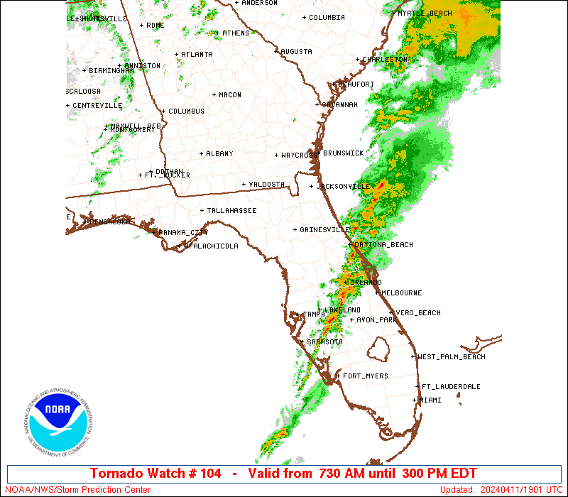
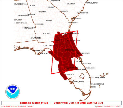
Tornado Watch Number 104
NWS Storm Prediction Center Norman OK
730 AM EDT Thu Apr 11 2024
The NWS Storm Prediction Center has issued a
* Tornado Watch for portions of
North and Central Florida
Southern Georgia
Coastal Waters
* Effective this Thursday morning and afternoon from 730 AM until
300 PM EDT.
* Primary threats include...
A couple tornadoes possible
Scattered damaging wind gusts to 70 mph possible
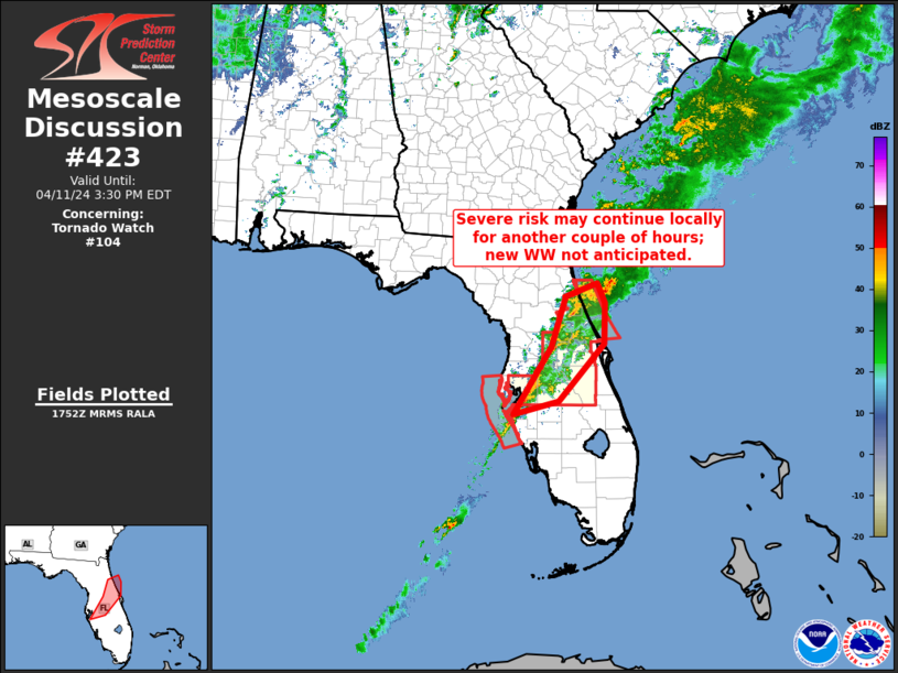
SUMMARY...A pre-frontal broken band of storms will gradually shift
east across the watch area through the morning and into the early
afternoon. A few supercells and line segments will probably pose
some risk for a few tornadoes and damaging gusts.
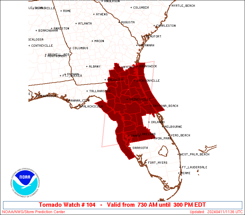
The tornado watch area is approximately along and 75 statute miles
east and west of a line from 15 miles west northwest of Brunswick GA
to 20 miles south southwest of Saint Petersburg FL. For a complete
depiction of the watch see the associated watch outline update
(WOUS64 KWNS WOU4).
PRECAUTIONARY/PREPAREDNESS ACTIONS...
REMEMBER...A Tornado Watch means conditions are favorable for
tornadoes and severe thunderstorms in and close to the watch
area. Persons in these areas should be on the lookout for
threatening weather conditions and listen for later statements
and possible warnings.
&&
AVIATION...Tornadoes and a few severe thunderstorms with hail
surface and aloft to 1 inch. Extreme turbulence and surface wind
gusts to 60 knots. A few cumulonimbi with maximum tops to 500. Mean
storm motion vector 23035.
...Smith
 Note:
The Aviation Watch (SAW) product is an approximation to the watch area.
The actual watch is depicted by the shaded areas.
Note:
The Aviation Watch (SAW) product is an approximation to the watch area.
The actual watch is depicted by the shaded areas.
   SAW4
   WW 104 TORNADO FL GA CW 111130Z - 111900Z
   AXIS..75 STATUTE MILES EAST AND WEST OF LINE..
   15WNW SSI/BRUNSWICK GA/ - 20SSW PIE/SAINT PETERSBURG FL/
   ..AVIATION COORDS.. 65NM E/W /46ESE AMG - 17SSW PIE/
   HAIL SURFACE AND ALOFT..1 INCH. WIND GUSTS..60 KNOTS.
   MAX TOPS TO 500. MEAN STORM MOTION VECTOR 23035.

   LAT...LON 31238042 27658158 27658403 31238295

   THIS IS AN APPROXIMATION TO THE WATCH AREA.  FOR A
   COMPLETE DEPICTION OF THE WATCH SEE WOUS64 KWNS
   FOR WOU4.
Watch 104 Status Report Messages:
STATUS REPORT #3 ON WW 104

VALID 111745Z - 111840Z

SEVERE WEATHER THREAT CONTINUES RIGHT OF A LINE FROM 15 N SRQ TO
25 SSW SGJ TO 45 ENE SGJ.

..GOSS..04/11/24

ATTN...WFO...JAX...TBW...TAE...MLB...

&&

STATUS REPORT FOR WT 104

SEVERE WEATHER THREAT CONTINUES FOR THE FOLLOWING AREAS

FLC035-057-069-103-105-127-111840-

FL
.    FLORIDA COUNTIES INCLUDED ARE

FLAGLER 	     HILLSBOROUGH	 LAKE
PINELLAS	     POLK		 VOLUSIA
$$


AMZ454-550-GMZ830-853-111840-

CW

.    ADJACENT COASTAL WATERS INCLUDED ARE

COASTAL WATERS FROM ST. AUGUSTINE TO FLAGLER BEACH FL OUT 20 NM

FLAGLER BEACH TO VOLUSIA-BREVARD COUNTY LINE 0-20 NM

TAMPA BAY WATERS

COASTAL WATERS FROM ENGLEWOOD TO TARPON SPRINGS FL OUT 20 NM

$$
THE WATCH STATUS MESSAGE IS FOR GUIDANCE PURPOSES ONLY.  PLEASE
REFER TO WATCH COUNTY NOTIFICATION STATEMENTS FOR OFFICIAL
INFORMATION ON COUNTIES...INDEPENDENT CITIES AND MARINE ZONES
CLEARED FROM SEVERE THUNDERSTORM AND TORNADO WATCHES.
$$

STATUS REPORT #2 ON WW 104

VALID 111545Z - 111640Z

SEVERE WEATHER THREAT CONTINUES RIGHT OF A LINE FROM 55 WSW PIE
TO 10 SSW GNV TO 60 ESE SSI.

..GOSS..04/11/24

ATTN...WFO...JAX...TBW...TAE...MLB...

&&

STATUS REPORT FOR WT 104

SEVERE WEATHER THREAT CONTINUES FOR THE FOLLOWING AREAS

FLC017-019-035-053-057-069-083-101-103-105-107-109-119-127-
111640-

FL
.    FLORIDA COUNTIES INCLUDED ARE

CITRUS		     CLAY		 FLAGLER
HERNANDO	     HILLSBOROUGH	 LAKE
MARION		     PASCO		 PINELLAS
POLK		     PUTNAM		 ST. JOHNS
SUMTER		     VOLUSIA
$$


AMZ452-454-550-GMZ830-850-853-111640-

CW

.    ADJACENT COASTAL WATERS INCLUDED ARE

COASTAL WATERS FROM FERNANDINA BEACH TO ST. AUGUSTINE FL OUT 20
NM

COASTAL WATERS FROM ST. AUGUSTINE TO FLAGLER BEACH FL OUT 20 NM

FLAGLER BEACH TO VOLUSIA-BREVARD COUNTY LINE 0-20 NM

TAMPA BAY WATERS

COASTAL WATERS FROM TARPON SPRINGS TO SUWANNEE RIVER FL OUT 20 NM

COASTAL WATERS FROM ENGLEWOOD TO TARPON SPRINGS FL OUT 20 NM

$$
THE WATCH STATUS MESSAGE IS FOR GUIDANCE PURPOSES ONLY.  PLEASE
REFER TO WATCH COUNTY NOTIFICATION STATEMENTS FOR OFFICIAL
INFORMATION ON COUNTIES...INDEPENDENT CITIES AND MARINE ZONES
CLEARED FROM SEVERE THUNDERSTORM AND TORNADO WATCHES.
$$

STATUS REPORT #1 ON WW 104

VALID 111435Z - 111540Z

SEVERE WEATHER THREAT CONTINUES RIGHT OF A LINE FROM 80 WSW PIE
TO 40 WSW JAX TO 15 NE SSI.

..GOSS..04/11/24

ATTN...WFO...JAX...TBW...TAE...MLB...

&&

STATUS REPORT FOR WT 104

SEVERE WEATHER THREAT CONTINUES FOR THE FOLLOWING AREAS

FLC001-003-007-017-019-031-035-041-053-057-069-075-083-101-103-
105-107-109-119-125-127-111540-

FL
.    FLORIDA COUNTIES INCLUDED ARE

ALACHUA 	     BAKER		 BRADFORD
CITRUS		     CLAY		 DUVAL
FLAGLER 	     GILCHRIST		 HERNANDO
HILLSBOROUGH	     LAKE		 LEVY
MARION		     PASCO		 PINELLAS
POLK		     PUTNAM		 ST. JOHNS
SUMTER		     UNION		 VOLUSIA
$$


AMZ450-452-454-550-GMZ830-850-853-111540-

CW

.    ADJACENT COASTAL WATERS INCLUDED ARE

COASTAL WATERS FROM ALTAMAHA SOUND TO FERNANDINA BEACH FL OUT 20
NM

COASTAL WATERS FROM FERNANDINA BEACH TO ST. AUGUSTINE FL OUT 20
NM

COASTAL WATERS FROM ST. AUGUSTINE TO FLAGLER BEACH FL OUT 20 NM

FLAGLER BEACH TO VOLUSIA-BREVARD COUNTY LINE 0-20 NM

TAMPA BAY WATERS

COASTAL WATERS FROM TARPON SPRINGS TO SUWANNEE RIVER FL OUT 20 NM

COASTAL WATERS FROM ENGLEWOOD TO TARPON SPRINGS FL OUT 20 NM

$$
THE WATCH STATUS MESSAGE IS FOR GUIDANCE PURPOSES ONLY.  PLEASE
REFER TO WATCH COUNTY NOTIFICATION STATEMENTS FOR OFFICIAL
INFORMATION ON COUNTIES...INDEPENDENT CITIES AND MARINE ZONES
CLEARED FROM SEVERE THUNDERSTORM AND TORNADO WATCHES.
$$
Note:
Click for Complete Product Text.
Tornadoes
Probability of 2 or more tornadoes
|
Mod (40%)
|
Probability of 1 or more strong (EF2-EF5) tornadoes
|
Low (20%)
|
Wind
Probability of 10 or more severe wind events
|
Mod (40%)
|
Probability of 1 or more wind events > 65 knots
|
Low (20%)
|
Hail
Probability of 10 or more severe hail events
|
Low (<5%)
|
Probability of 1 or more hailstones > 2 inches
|
Low (<5%)
|
Combined Severe Hail/Wind
Probability of 6 or more combined severe hail/wind events
|
Mod (50%)
|
For each watch, probabilities for particular events inside the watch
(listed above in each table) are determined by the issuing forecaster.
The "Low" category contains probability values ranging from less than 2%
to 20% (EF2-EF5 tornadoes), less than 5% to 20% (all other probabilities),
"Moderate" from 30% to 60%, and "High" from 70% to greater than 95%.
High values are bolded and lighter in color to provide awareness of
an increased threat for a particular event.


 @NWSSPC