Note:
The expiration time in the watch graphic is amended if the watch is
replaced, cancelled or extended.
Note:
Note:
The expiration time in the watch graphic is amended if the watch is
replaced, cancelled or extended.
Note: Click for
Watch Status Reports.
   SEL3

   URGENT - IMMEDIATE BROADCAST REQUESTED
   Tornado Watch Number 103
   NWS Storm Prediction Center Norman OK
   110 PM CDT Wed Apr 10 2024

   The NWS Storm Prediction Center has issued a

   * Tornado Watch for portions of
     Southeast Alabama
     Florida Panhandle
     Southwest Georgia
     Coastal Waters

   * Effective this Wednesday afternoon and evening from 110 PM
     until 800 PM CDT.

   * Primary threats include...
     A few tornadoes and a couple intense tornadoes possible
     Scattered damaging winds likely with isolated significant gusts
       to 75 mph possible

   SUMMARY...A cluster of storms are expected to move into the region
   through mid/late afternoon, with the potential for damaging winds
   and a few tornadoes expected to increase and potentially persist
   through at least early/mid evening in some areas.

   The tornado watch area is approximately along and 60 statute miles
   east and west of a line from 40 miles north northeast of Dothan AL
   to 30 miles west southwest of Apalachicola FL. For a complete
   depiction of the watch see the associated watch outline update
   (WOUS64 KWNS WOU3).

   PRECAUTIONARY/PREPAREDNESS ACTIONS...

   REMEMBER...A Tornado Watch means conditions are favorable for
   tornadoes and severe thunderstorms in and close to the watch
   area. Persons in these areas should be on the lookout for
   threatening weather conditions and listen for later statements
   and possible warnings.

   &&

   OTHER WATCH INFORMATION...CONTINUE...WW 102...

   AVIATION...Tornadoes and a few severe thunderstorms with hail
   surface and aloft to 1.5 inches. Extreme turbulence and surface wind
   gusts to 65 knots. A few cumulonimbi with maximum tops to 500. Mean
   storm motion vector 25040.

   ...Guyer
 Note:
The Aviation Watch (SAW) product is an approximation to the watch area.
The actual watch is depicted by the shaded areas.
Note:
The Aviation Watch (SAW) product is an approximation to the watch area.
The actual watch is depicted by the shaded areas.
   SAW3
   WW 103 TORNADO AL FL GA CW 101810Z - 110100Z
   AXIS..60 STATUTE MILES EAST AND WEST OF LINE..
   40NNE DHN/DOTHAN AL/ - 30WSW AAF/APALACHICOLA FL/
   ..AVIATION COORDS.. 50NM E/W /47WNW PZD - 84SW TLH/
   HAIL SURFACE AND ALOFT..1.5 INCHES. WIND GUSTS..65 KNOTS.
   MAX TOPS TO 500. MEAN STORM MOTION VECTOR 25040.

   LAT...LON 31858417 29568449 29568649 31858621

   THIS IS AN APPROXIMATION TO THE WATCH AREA.  FOR A
   COMPLETE DEPICTION OF THE WATCH SEE WOUS64 KWNS
   FOR WOU3.
Watch 103 Status Report Messages:
STATUS REPORT #6 ON WW 103
VALID 110025Z - 110100Z
SEVERE WEATHER THREAT CONTINUES RIGHT OF A LINE FROM 50 WSW PFN
TO 10 NNW PFN TO 25 SW MAI TO TLH.
REMAINING VALID PORTION OF WW 103 MAY BE ALLOWED TO EXPIRE AT
11/01Z.
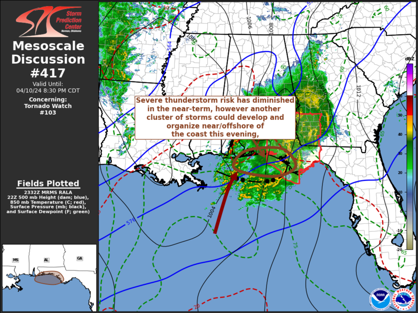
FOR ADDITIONAL INFORMATION SEE MESOSCALE DISCUSSION 417.
..KERR..04/11/24
ATTN...WFO...BMX...TAE...
&&
STATUS REPORT FOR WT 103
SEVERE WEATHER THREAT CONTINUES FOR THE FOLLOWING AREAS
FLC005-013-037-045-077-129-133-110100-
FL
. FLORIDA COUNTIES INCLUDED ARE
BAY CALHOUN FRANKLIN
GULF LIBERTY WAKULLA
WASHINGTON
$$
GMZ750-752-110100-
CW
. ADJACENT COASTAL WATERS INCLUDED ARE
COASTAL WATERS FROM OKALOOSA-WALTON COUNTY LINE TO MEXICO BEACH
OUT 20 NM
COASTAL WATERS FROM MEXICO BEACH TO APALACHICOLA OUT 20 NM
$$
THE WATCH STATUS MESSAGE IS FOR GUIDANCE PURPOSES ONLY. PLEASE
REFER TO WATCH COUNTY NOTIFICATION STATEMENTS FOR OFFICIAL
INFORMATION ON COUNTIES...INDEPENDENT CITIES AND MARINE ZONES
CLEARED FROM SEVERE THUNDERSTORM AND TORNADO WATCHES.
$$
STATUS REPORT #5 ON WW 103
VALID 102340Z - 110040Z
SEVERE WEATHER THREAT CONTINUES RIGHT OF A LINE FROM 45 S CEW TO
20 NW PFN TO 10 NE MAI TO 30 WSW MGR.
..KERR..04/10/24
ATTN...WFO...BMX...TAE...
&&
STATUS REPORT FOR WT 103
SEVERE WEATHER THREAT CONTINUES FOR THE FOLLOWING AREAS
FLC005-013-037-039-045-063-073-077-129-133-110040-
FL
. FLORIDA COUNTIES INCLUDED ARE
BAY CALHOUN FRANKLIN
GADSDEN GULF JACKSON
LEON LIBERTY WAKULLA
WASHINGTON
$$
GAC087-131-253-110040-
GA
. GEORGIA COUNTIES INCLUDED ARE
DECATUR GRADY SEMINOLE
$$
GMZ750-752-110040-
CW
. ADJACENT COASTAL WATERS INCLUDED ARE
COASTAL WATERS FROM OKALOOSA-WALTON COUNTY LINE TO MEXICO BEACH
OUT 20 NM
COASTAL WATERS FROM MEXICO BEACH TO APALACHICOLA OUT 20 NM
$$
THE WATCH STATUS MESSAGE IS FOR GUIDANCE PURPOSES ONLY. PLEASE
REFER TO WATCH COUNTY NOTIFICATION STATEMENTS FOR OFFICIAL
INFORMATION ON COUNTIES...INDEPENDENT CITIES AND MARINE ZONES
CLEARED FROM SEVERE THUNDERSTORM AND TORNADO WATCHES.
$$
STATUS REPORT #4 ON WW 103
VALID 102230Z - 102340Z
SEVERE WEATHER THREAT CONTINUES RIGHT OF A LINE FROM 25 SSE CEW
TO 10 ESE DHN TO 20 S ABY.
..KERR..04/10/24
ATTN...WFO...BMX...TAE...
&&
STATUS REPORT FOR WT 103
SEVERE WEATHER THREAT CONTINUES FOR THE FOLLOWING AREAS
ALC069-102340-
AL
. ALABAMA COUNTIES INCLUDED ARE
HOUSTON
$$
FLC005-013-037-039-045-063-073-077-129-133-102340-
FL
. FLORIDA COUNTIES INCLUDED ARE
BAY CALHOUN FRANKLIN
GADSDEN GULF JACKSON
LEON LIBERTY WAKULLA
WASHINGTON
$$
GAC087-131-201-253-102340-
GA
. GEORGIA COUNTIES INCLUDED ARE
DECATUR GRADY MILLER
SEMINOLE
$$
GMZ750-752-102340-
CW
. ADJACENT COASTAL WATERS INCLUDED ARE
COASTAL WATERS FROM OKALOOSA-WALTON COUNTY LINE TO MEXICO BEACH
OUT 20 NM
COASTAL WATERS FROM MEXICO BEACH TO APALACHICOLA OUT 20 NM
$$
THE WATCH STATUS MESSAGE IS FOR GUIDANCE PURPOSES ONLY. PLEASE
REFER TO WATCH COUNTY NOTIFICATION STATEMENTS FOR OFFICIAL
INFORMATION ON COUNTIES...INDEPENDENT CITIES AND MARINE ZONES
CLEARED FROM SEVERE THUNDERSTORM AND TORNADO WATCHES.
$$
STATUS REPORT #3 ON WW 103
VALID 102230Z - 102340Z
SEVERE WEATHER THREAT CONTINUES RIGHT OF A LINE FROM 25 SSE CEW
TO 10 ESE DHN TO 20 S ABY.
..KERR..04/10/24
ATTN...WFO...BMX...TAE...
&&
STATUS REPORT FOR WT 103
SEVERE WEATHER THREAT CONTINUES FOR THE FOLLOWING AREAS
ALC069-102340-
AL
. ALABAMA COUNTIES INCLUDED ARE
HOUSTON
$$
FLC005-013-037-039-045-063-073-077-129-133-102340-
FL
. FLORIDA COUNTIES INCLUDED ARE
BAY CALHOUN FRANKLIN
GADSDEN GULF JACKSON
LEON LIBERTY WAKULLA
WASHINGTON
$$
GAC087-131-201-253-102340-
GA
. GEORGIA COUNTIES INCLUDED ARE
DECATUR GRADY MILLER
SEMINOLE
$$
GMZ750-752-102340-
CW
. ADJACENT COASTAL WATERS INCLUDED ARE
COASTAL WATERS FROM OKALOOSA-WALTON COUNTY LINE TO MEXICO BEACH
OUT 20 NM
COASTAL WATERS FROM MEXICO BEACH TO APALACHICOLA OUT 20 NM
$$
THE WATCH STATUS MESSAGE IS FOR GUIDANCE PURPOSES ONLY. PLEASE
REFER TO WATCH COUNTY NOTIFICATION STATEMENTS FOR OFFICIAL
INFORMATION ON COUNTIES...INDEPENDENT CITIES AND MARINE ZONES
CLEARED FROM SEVERE THUNDERSTORM AND TORNADO WATCHES.
$$
STATUS REPORT #2 ON WW 103
VALID 102130Z - 102240Z
SEVERE WEATHER THREAT CONTINUES RIGHT OF A LINE FROM 25 SSE CEW
TO 25 SW DHN TO 45 NNE DHN.
..KERR..04/10/24
ATTN...WFO...BMX...TAE...
&&
STATUS REPORT FOR WT 103
SEVERE WEATHER THREAT CONTINUES FOR THE FOLLOWING AREAS
ALC069-102240-
AL
. ALABAMA COUNTIES INCLUDED ARE
HOUSTON
$$
FLC005-013-037-039-045-059-063-073-077-129-131-133-102240-
FL
. FLORIDA COUNTIES INCLUDED ARE
BAY CALHOUN FRANKLIN
GADSDEN GULF HOLMES
JACKSON LEON LIBERTY
WAKULLA WALTON WASHINGTON
$$
GAC007-037-061-087-095-099-131-177-201-205-243-253-273-102240-
GA
. GEORGIA COUNTIES INCLUDED ARE
BAKER CALHOUN CLAY
DECATUR DOUGHERTY EARLY
GRADY LEE MILLER
MITCHELL RANDOLPH SEMINOLE
TERRELL
$$
GMZ750-752-102240-
CW
. ADJACENT COASTAL WATERS INCLUDED ARE
COASTAL WATERS FROM OKALOOSA-WALTON COUNTY LINE TO MEXICO BEACH
OUT 20 NM
COASTAL WATERS FROM MEXICO BEACH TO APALACHICOLA OUT 20 NM
$$
THE WATCH STATUS MESSAGE IS FOR GUIDANCE PURPOSES ONLY. PLEASE
REFER TO WATCH COUNTY NOTIFICATION STATEMENTS FOR OFFICIAL
INFORMATION ON COUNTIES...INDEPENDENT CITIES AND MARINE ZONES
CLEARED FROM SEVERE THUNDERSTORM AND TORNADO WATCHES.
$$
STATUS REPORT #1 ON WW 103
VALID 101940Z - 102040Z
THE SEVERE WEATHER THREAT CONTINUES ACROSS THE ENTIRE WATCH AREA.
..LEITMAN..04/10/24
ATTN...WFO...BMX...TAE...
&&
STATUS REPORT FOR WT 103
SEVERE WEATHER THREAT CONTINUES FOR THE FOLLOWING AREAS
ALC005-031-045-061-067-069-109-102040-
AL
. ALABAMA COUNTIES INCLUDED ARE
BARBOUR COFFEE DALE
GENEVA HENRY HOUSTON
PIKE
$$
FLC005-013-037-039-045-059-063-073-077-129-131-133-102040-
FL
. FLORIDA COUNTIES INCLUDED ARE
BAY CALHOUN FRANKLIN
GADSDEN GULF HOLMES
JACKSON LEON LIBERTY
WAKULLA WALTON WASHINGTON
$$
GAC007-037-061-087-095-099-131-177-201-205-239-243-253-273-
102040-
GA
. GEORGIA COUNTIES INCLUDED ARE
BAKER CALHOUN CLAY
DECATUR DOUGHERTY EARLY
GRADY LEE MILLER
MITCHELL QUITMAN RANDOLPH
SEMINOLE TERRELL
$$
GMZ750-752-102040-
CW
. ADJACENT COASTAL WATERS INCLUDED ARE
COASTAL WATERS FROM OKALOOSA-WALTON COUNTY LINE TO MEXICO BEACH
OUT 20 NM
COASTAL WATERS FROM MEXICO BEACH TO APALACHICOLA OUT 20 NM
$$
THE WATCH STATUS MESSAGE IS FOR GUIDANCE PURPOSES ONLY. PLEASE
REFER TO WATCH COUNTY NOTIFICATION STATEMENTS FOR OFFICIAL
INFORMATION ON COUNTIES...INDEPENDENT CITIES AND MARINE ZONES
CLEARED FROM SEVERE THUNDERSTORM AND TORNADO WATCHES.
$$
Note:
Click for Complete Product Text.
Tornadoes
Probability of 2 or more tornadoes
|
Mod (50%)
|
Probability of 1 or more strong (EF2-EF5) tornadoes
|
Mod (50%)
|
Wind
Probability of 10 or more severe wind events
|
High (70%)
|
Probability of 1 or more wind events > 65 knots
|
Mod (40%)
|
Hail
Probability of 10 or more severe hail events
|
Low (10%)
|
Probability of 1 or more hailstones > 2 inches
|
Low (<5%)
|
Combined Severe Hail/Wind
Probability of 6 or more combined severe hail/wind events
|
High (90%)
|
For each watch, probabilities for particular events inside the watch
(listed above in each table) are determined by the issuing forecaster.
The "Low" category contains probability values ranging from less than 2%
to 20% (EF2-EF5 tornadoes), less than 5% to 20% (all other probabilities),
"Moderate" from 30% to 60%, and "High" from 70% to greater than 95%.
High values are bolded and lighter in color to provide awareness of
an increased threat for a particular event.


 @NWSSPC