Note:
The expiration time in the watch graphic is amended if the watch is
replaced, cancelled or extended.
Note:
Note:
The expiration time in the watch graphic is amended if the watch is
replaced, cancelled or extended.
Note: Click for
Watch Status Reports.
SEL5
URGENT - IMMEDIATE BROADCAST REQUESTED
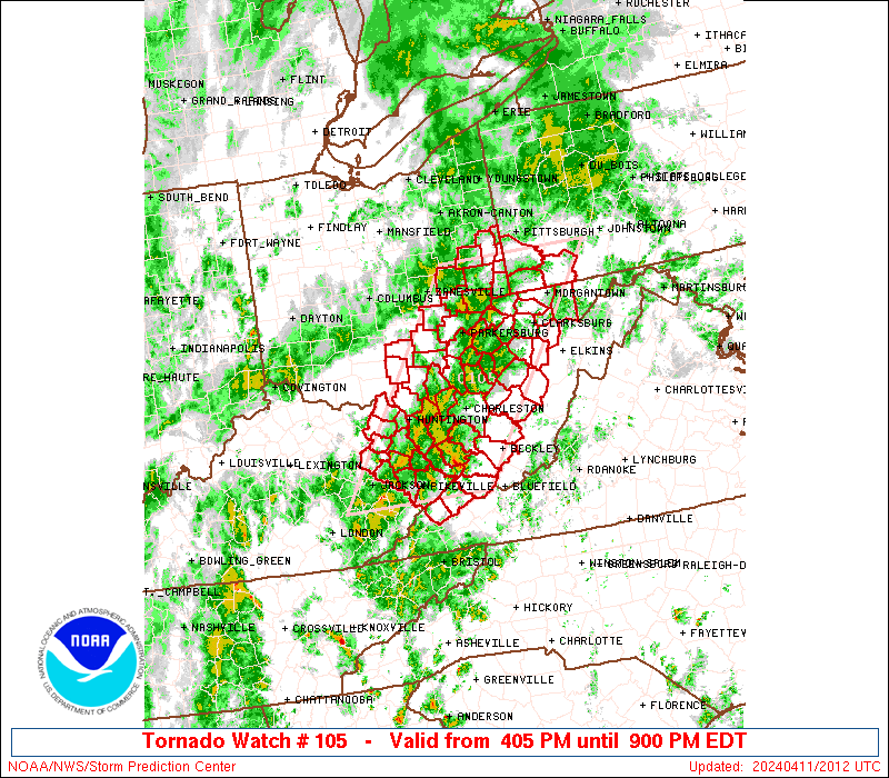
Tornado Watch Number 105
NWS Storm Prediction Center Norman OK
405 PM EDT Thu Apr 11 2024
The NWS Storm Prediction Center has issued a
* Tornado Watch for portions of
Eastern Kentucky
Southeast Ohio
Southwest Pennsylvania
Far Western Virginia
West Virginia
* Effective this Thursday afternoon and evening from 405 PM until
900 PM EDT.
* Primary threats include...
A few tornadoes possible
Scattered damaging wind gusts to 70 mph possible
Isolated large hail events to 1.5 inches in diameter possible
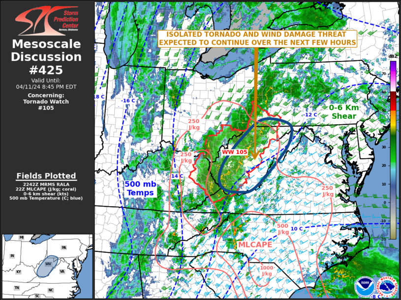
SUMMARY...At least widely scattered severe storms are expected to
develop and race generally northeastward through late afternoon and
evening, potentially including some supercells capable of a tornado
risk as well as damaging winds and possibly some hail.
The tornado watch area is approximately along and 65 statute miles
east and west of a line from 45 miles east southeast of Jackson KY
to 15 miles east northeast of Wheeling WV. For a complete depiction
of the watch see the associated watch outline update (WOUS64 KWNS
WOU5).
PRECAUTIONARY/PREPAREDNESS ACTIONS...
REMEMBER...A Tornado Watch means conditions are favorable for
tornadoes and severe thunderstorms in and close to the watch
area. Persons in these areas should be on the lookout for
threatening weather conditions and listen for later statements
and possible warnings.
&&
AVIATION...Tornadoes and a few severe thunderstorms with hail
surface and aloft to 1.5 inches. Extreme turbulence and surface wind
gusts to 60 knots. A few cumulonimbi with maximum tops to 450. Mean
storm motion vector 23035.
...Guyer

   SEL5

   URGENT - IMMEDIATE BROADCAST REQUESTED
   Tornado Watch Number 105
   NWS Storm Prediction Center Norman OK
   405 PM EDT Thu Apr 11 2024

   The NWS Storm Prediction Center has issued a

   * Tornado Watch for portions of
     Eastern Kentucky
     Southeast Ohio
     Southwest Pennsylvania
     Far Western Virginia
     West Virginia

   * Effective this Thursday afternoon and evening from 405 PM until
     900 PM EDT.

   * Primary threats include...
     A few tornadoes possible
     Scattered damaging wind gusts to 70 mph possible
     Isolated large hail events to 1.5 inches in diameter possible

   SUMMARY...At least widely scattered severe storms are expected to
   develop and race generally northeastward through late afternoon and
   evening, potentially including some supercells capable of a tornado
   risk as well as damaging winds and possibly some hail.

   The tornado watch area is approximately along and 65 statute miles
   east and west of a line from 45 miles east southeast of Jackson KY
   to 15 miles east northeast of Wheeling WV. For a complete depiction
   of the watch see the associated watch outline update (WOUS64 KWNS
   WOU5).

   PRECAUTIONARY/PREPAREDNESS ACTIONS...

   REMEMBER...A Tornado Watch means conditions are favorable for
   tornadoes and severe thunderstorms in and close to the watch
   area. Persons in these areas should be on the lookout for
   threatening weather conditions and listen for later statements
   and possible warnings.

   &&

   AVIATION...Tornadoes and a few severe thunderstorms with hail
   surface and aloft to 1.5 inches. Extreme turbulence and surface wind
   gusts to 60 knots. A few cumulonimbi with maximum tops to 450. Mean
   storm motion vector 23035.

   ...Guyer
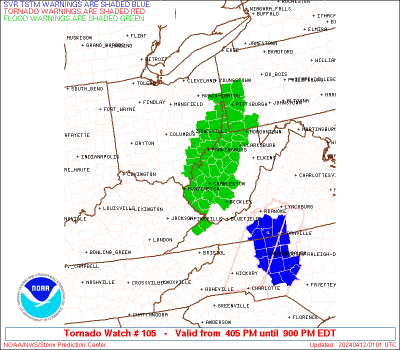
 Note:
The Aviation Watch (SAW) product is an approximation to the watch area.
The actual watch is depicted by the shaded areas.
Note:
The Aviation Watch (SAW) product is an approximation to the watch area.
The actual watch is depicted by the shaded areas.
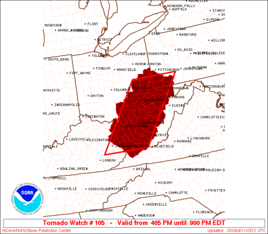
   SAW5
   WW 105 TORNADO KY OH PA VA WV 112005Z - 120100Z
   AXIS..65 STATUTE MILES EAST AND WEST OF LINE..
   45ESE JKL/JACKSON KY/ - 15ENE HLG/WHEELING WV/
   ..AVIATION COORDS.. 55NM E/W /56NNW HMV - 25NE AIR/
   HAIL SURFACE AND ALOFT..1.5 INCHES. WIND GUSTS..60 KNOTS.
   MAX TOPS TO 450. MEAN STORM MOTION VECTOR 23035.

   LAT...LON 37288381 40258162 40257915 37288144

   THIS IS AN APPROXIMATION TO THE WATCH AREA.  FOR A
   COMPLETE DEPICTION OF THE WATCH SEE WOUS64 KWNS
   FOR WOU5.
Watch 105 Status Report Messages:
STATUS REPORT #1 ON WW 105

VALID 112340Z - 120040Z

THE SEVERE WEATHER THREAT CONTINUES ACROSS THE ENTIRE WATCH AREA.

..BROYLES..04/11/24

ATTN...WFO...RLX...JKL...PBZ...

&&

STATUS REPORT FOR WT 105

SEVERE WEATHER THREAT CONTINUES FOR THE FOLLOWING AREAS

KYC019-043-063-071-089-115-127-153-159-175-195-120040-

KY
.    KENTUCKY COUNTIES INCLUDED ARE

BOYD		     CARTER		 ELLIOTT
FLOYD		     GREENUP		 JOHNSON
LAWRENCE	     MAGOFFIN		 MARTIN
MORGAN		     PIKE
$$


OHC009-013-053-059-067-079-081-087-105-111-115-121-163-167-
120040-

OH
.    OHIO COUNTIES INCLUDED ARE

ATHENS		     BELMONT		 GALLIA
GUERNSEY	     HARRISON		 JACKSON
JEFFERSON	     LAWRENCE		 MEIGS
MONROE		     MORGAN		 NOBLE
VINTON		     WASHINGTON
$$


PAC051-059-125-120040-

PA
.    PENNSYLVANIA COUNTIES INCLUDED ARE

FAYETTE 	     GREENE		 WASHINGTON
$$


VAC027-051-120040-

VA
.    VIRGINIA COUNTIES INCLUDED ARE

BUCHANAN	     DICKENSON
$$


WVC001-005-007-009-011-013-015-017-019-021-029-033-035-039-041-
043-045-047-049-051-053-059-061-067-069-073-077-079-081-085-087-
091-095-097-099-101-103-105-107-109-120040-

WV
.    WEST VIRGINIA COUNTIES INCLUDED ARE

BARBOUR 	     BOONE		 BRAXTON
BROOKE		     CABELL		 CALHOUN
CLAY		     DODDRIDGE		 FAYETTE
GILMER		     HANCOCK		 HARRISON
JACKSON 	     KANAWHA		 LEWIS
LINCOLN 	     LOGAN		 MCDOWELL
MARION		     MARSHALL		 MASON
MINGO		     MONONGALIA 	 NICHOLAS
OHIO		     PLEASANTS		 PRESTON
PUTNAM		     RALEIGH		 RITCHIE
ROANE		     TAYLOR		 TYLER
UPSHUR		     WAYNE		 WEBSTER
WETZEL		     WIRT		 WOOD
WYOMING
$$


THE WATCH STATUS MESSAGE IS FOR GUIDANCE PURPOSES ONLY.  PLEASE
REFER TO WATCH COUNTY NOTIFICATION STATEMENTS FOR OFFICIAL
INFORMATION ON COUNTIES...INDEPENDENT CITIES AND MARINE ZONES
CLEARED FROM SEVERE THUNDERSTORM AND TORNADO WATCHES.
$$
Note:
Click for Complete Product Text.
Tornadoes
Probability of 2 or more tornadoes
|
Mod (50%)
|
Probability of 1 or more strong (EF2-EF5) tornadoes
|
Low (20%)
|
Wind
Probability of 10 or more severe wind events
|
Mod (50%)
|
Probability of 1 or more wind events > 65 knots
|
Low (20%)
|
Hail
Probability of 10 or more severe hail events
|
Low (20%)
|
Probability of 1 or more hailstones > 2 inches
|
Low (10%)
|
Combined Severe Hail/Wind
Probability of 6 or more combined severe hail/wind events
|
High (80%)
|
For each watch, probabilities for particular events inside the watch
(listed above in each table) are determined by the issuing forecaster.
The "Low" category contains probability values ranging from less than 2%
to 20% (EF2-EF5 tornadoes), less than 5% to 20% (all other probabilities),
"Moderate" from 30% to 60%, and "High" from 70% to greater than 95%.
High values are bolded and lighter in color to provide awareness of
an increased threat for a particular event.


 @NWSSPC