 Note:
The expiration time in the watch graphic is amended if the watch is
replaced, cancelled or extended.
Note:
Note:
The expiration time in the watch graphic is amended if the watch is
replaced, cancelled or extended.
Note: Click for
Watch Status Reports.
SEL2
URGENT - IMMEDIATE BROADCAST REQUESTED
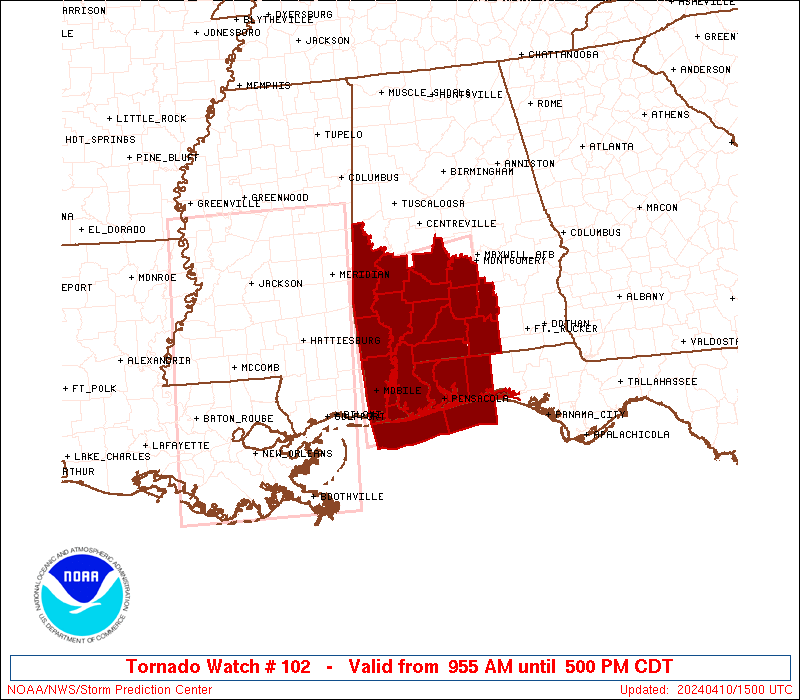
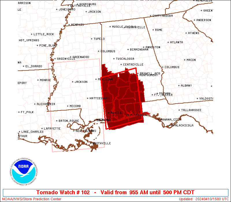
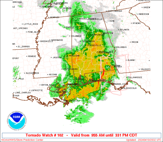
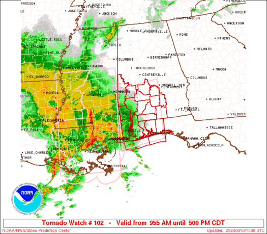
Tornado Watch Number 102
NWS Storm Prediction Center Norman OK
955 AM CDT Wed Apr 10 2024
The NWS Storm Prediction Center has issued a
* Tornado Watch for portions of
Southern Alabama
Florida Panhandle
Coastal Waters
* Effective this Wednesday morning and afternoon from 955 AM
until 500 PM CDT.
* Primary threats include...
A few tornadoes likely with a couple intense tornadoes possible
Widespread damaging winds likely with isolated significant gusts
to 80 mph possible
SUMMARY...Conditions will become increasingly favorable for severe
storms as tornadoes as additional moistening and destabilization
occurs, with storms increasing ahead of a squall line, potentially
leading to multiple rounds of severe storms in some areas through
mid into late afternoon.
The tornado watch area is approximately along and 85 statute miles
north and south of a line from 35 miles north northwest of Mobile AL
to 35 miles east of Evergreen AL. For a complete depiction of the
watch see the associated watch outline update (WOUS64 KWNS WOU2).
PRECAUTIONARY/PREPAREDNESS ACTIONS...
REMEMBER...A Tornado Watch means conditions are favorable for
tornadoes and severe thunderstorms in and close to the watch
area. Persons in these areas should be on the lookout for
threatening weather conditions and listen for later statements
and possible warnings.
&&
OTHER WATCH INFORMATION...CONTINUE...WW 101...
AVIATION...Tornadoes and a few severe thunderstorms with hail
surface and aloft to 1.5 inches. Extreme turbulence and surface wind
gusts to 70 knots. A few cumulonimbi with maximum tops to 500. Mean
storm motion vector 24040.
...Guyer
   SEL2

   URGENT - IMMEDIATE BROADCAST REQUESTED
   Tornado Watch Number 102
   NWS Storm Prediction Center Norman OK
   955 AM CDT Wed Apr 10 2024

   The NWS Storm Prediction Center has issued a

   * Tornado Watch for portions of
     Southern Alabama
     Florida Panhandle
     Coastal Waters

   * Effective this Wednesday morning and afternoon from 955 AM
     until 500 PM CDT.

   * Primary threats include...
     A few tornadoes likely with a couple intense tornadoes possible
     Widespread damaging winds likely with isolated significant gusts
       to 80 mph possible

   SUMMARY...Conditions will become increasingly favorable for severe
   storms as tornadoes as additional moistening and destabilization
   occurs, with storms increasing ahead of a squall line, potentially
   leading to multiple rounds of severe storms in some areas through
   mid into late afternoon.

   The tornado watch area is approximately along and 85 statute miles
   north and south of a line from 35 miles north northwest of Mobile AL
   to 35 miles east of Evergreen AL. For a complete depiction of the
   watch see the associated watch outline update (WOUS64 KWNS WOU2).

   PRECAUTIONARY/PREPAREDNESS ACTIONS...

   REMEMBER...A Tornado Watch means conditions are favorable for
   tornadoes and severe thunderstorms in and close to the watch
   area. Persons in these areas should be on the lookout for
   threatening weather conditions and listen for later statements
   and possible warnings.

   &&

   OTHER WATCH INFORMATION...CONTINUE...WW 101...

   AVIATION...Tornadoes and a few severe thunderstorms with hail
   surface and aloft to 1.5 inches. Extreme turbulence and surface wind
   gusts to 70 knots. A few cumulonimbi with maximum tops to 500. Mean
   storm motion vector 24040.

   ...Guyer
 Note:
The Aviation Watch (SAW) product is an approximation to the watch area.
The actual watch is depicted by the shaded areas.
Note:
The Aviation Watch (SAW) product is an approximation to the watch area.
The actual watch is depicted by the shaded areas.
   SAW2
   WW 102 TORNADO AL FL CW 101455Z - 102200Z
   AXIS..85 STATUTE MILES NORTH AND SOUTH OF LINE..
   35NNW MOB/MOBILE AL/ - 35E GZH/EVERGREEN AL/
   ..AVIATION COORDS.. 75NM N/S /26NNW SJI - 37NNE CEW/
   HAIL SURFACE AND ALOFT..1.5 INCHES. WIND GUSTS..70 KNOTS.
   MAX TOPS TO 500. MEAN STORM MOTION VECTOR 24040.

   LAT...LON 32388848 32658645 30198645 29928848

   THIS IS AN APPROXIMATION TO THE WATCH AREA.  FOR A
   COMPLETE DEPICTION OF THE WATCH SEE WOUS64 KWNS
   FOR WOU2.
Watch 102 Status Report Messages:
STATUS REPORT #5 ON WW 102

VALID 101940Z - 102040Z

SEVERE WEATHER THREAT CONTINUES RIGHT OF A LINE FROM 40 SE GPT TO
20 SSW PNS TO 20 ENE GZH TO 15 S TOI.

..LEITMAN..04/10/24

ATTN...WFO...MOB...BMX...

&&

STATUS REPORT FOR WT 102

SEVERE WEATHER THREAT CONTINUES FOR THE FOLLOWING AREAS

ALC039-102040-

AL
.    ALABAMA COUNTIES INCLUDED ARE

COVINGTON
$$


FLC091-113-102040-

FL
.    FLORIDA COUNTIES INCLUDED ARE

OKALOOSA	     SANTA ROSA
$$


GMZ634-635-636-650-655-102040-

CW

.    ADJACENT COASTAL WATERS INCLUDED ARE

PENSACOLA BAY AREA INCLUDING SANTA ROSA SOUND

WESTERN CHOCTAWHATCHEE BAY

EASTERN CHOCTAWHATCHEE BAY

COASTAL WATERS FROM PENSACOLA FL TO PASCAGOULA MS OUT 20 NM

COASTAL WATERS FROM OKALOOSA-WALTON COUNTY LINE TO PENSACOLA FL
OUT 20 NM

$$
THE WATCH STATUS MESSAGE IS FOR GUIDANCE PURPOSES ONLY.  PLEASE
REFER TO WATCH COUNTY NOTIFICATION STATEMENTS FOR OFFICIAL
INFORMATION ON COUNTIES...INDEPENDENT CITIES AND MARINE ZONES
CLEARED FROM SEVERE THUNDERSTORM AND TORNADO WATCHES.
$$

STATUS REPORT #4 ON WW 102

VALID 101850Z - 101940Z

SEVERE WEATHER THREAT CONTINUES RIGHT OF A LINE FROM 40 SSW MOB
TO 30 WSW PNS TO 15 WSW GZH TO 15 NW TOI.

..LEITMAN..04/10/24

ATTN...WFO...MOB...BMX...

&&

STATUS REPORT FOR WT 102

SEVERE WEATHER THREAT CONTINUES FOR THE FOLLOWING AREAS

ALC013-035-039-041-053-101940-

AL
.    ALABAMA COUNTIES INCLUDED ARE

BUTLER		     CONECUH		 COVINGTON
CRENSHAW	     ESCAMBIA
$$


FLC033-091-113-101940-

FL
.    FLORIDA COUNTIES INCLUDED ARE

ESCAMBIA	     OKALOOSA		 SANTA ROSA
$$


GMZ633-634-635-636-650-655-101940-

CW

.    ADJACENT COASTAL WATERS INCLUDED ARE

PERDIDO BAY AREA

PENSACOLA BAY AREA INCLUDING SANTA ROSA SOUND

WESTERN CHOCTAWHATCHEE BAY

EASTERN CHOCTAWHATCHEE BAY

COASTAL WATERS FROM PENSACOLA FL TO PASCAGOULA MS OUT 20 NM

COASTAL WATERS FROM OKALOOSA-WALTON COUNTY LINE TO PENSACOLA FL
OUT 20 NM

$$
THE WATCH STATUS MESSAGE IS FOR GUIDANCE PURPOSES ONLY.  PLEASE
REFER TO WATCH COUNTY NOTIFICATION STATEMENTS FOR OFFICIAL
INFORMATION ON COUNTIES...INDEPENDENT CITIES AND MARINE ZONES
CLEARED FROM SEVERE THUNDERSTORM AND TORNADO WATCHES.
$$

STATUS REPORT #3 ON WW 102

VALID 101745Z - 101840Z

SEVERE WEATHER THREAT CONTINUES RIGHT OF A LINE FROM 30 ESE GPT
TO 30 N MOB TO 25 SSW SEM TO 15 SSE MGM.

..LEITMAN..04/10/24

ATTN...WFO...MOB...BMX...

&&

STATUS REPORT FOR WT 102

SEVERE WEATHER THREAT CONTINUES FOR THE FOLLOWING AREAS

ALC003-013-035-039-041-053-097-099-101840-

AL
.    ALABAMA COUNTIES INCLUDED ARE

BALDWIN 	     BUTLER		 CONECUH
COVINGTON	     CRENSHAW		 ESCAMBIA
MOBILE		     MONROE
$$


FLC033-091-113-101840-

FL
.    FLORIDA COUNTIES INCLUDED ARE

ESCAMBIA	     OKALOOSA		 SANTA ROSA
$$


GMZ630-631-632-633-634-635-636-650-655-101840-

CW

.    ADJACENT COASTAL WATERS INCLUDED ARE

NORTH MOBILE BAY

SOUTH MOBILE BAY

MISSISSIPPI SOUND

PERDIDO BAY AREA

PENSACOLA BAY AREA INCLUDING SANTA ROSA SOUND

WESTERN CHOCTAWHATCHEE BAY

EASTERN CHOCTAWHATCHEE BAY

COASTAL WATERS FROM PENSACOLA FL TO PASCAGOULA MS OUT 20 NM

COASTAL WATERS FROM OKALOOSA-WALTON COUNTY LINE TO PENSACOLA FL
OUT 20 NM

$$
THE WATCH STATUS MESSAGE IS FOR GUIDANCE PURPOSES ONLY.  PLEASE
REFER TO WATCH COUNTY NOTIFICATION STATEMENTS FOR OFFICIAL
INFORMATION ON COUNTIES...INDEPENDENT CITIES AND MARINE ZONES
CLEARED FROM SEVERE THUNDERSTORM AND TORNADO WATCHES.
$$

STATUS REPORT #2 ON WW 102

VALID 101650Z - 101740Z

THE SEVERE WEATHER THREAT CONTINUES ACROSS THE ENTIRE WATCH AREA.

..LEITMAN..04/10/24

ATTN...WFO...MOB...BMX...

&&

STATUS REPORT FOR WT 102

SEVERE WEATHER THREAT CONTINUES FOR THE FOLLOWING AREAS

ALC003-013-023-025-035-039-041-047-053-085-091-097-099-119-129-
131-101740-

AL
.    ALABAMA COUNTIES INCLUDED ARE

BALDWIN 	     BUTLER		 CHOCTAW
CLARKE		     CONECUH		 COVINGTON
CRENSHAW	     DALLAS		 ESCAMBIA
LOWNDES 	     MARENGO		 MOBILE
MONROE		     SUMTER		 WASHINGTON
WILCOX
$$


FLC033-091-113-101740-

FL
.    FLORIDA COUNTIES INCLUDED ARE

ESCAMBIA	     OKALOOSA		 SANTA ROSA
$$


GMZ630-631-632-633-634-635-636-650-655-101740-

CW

.    ADJACENT COASTAL WATERS INCLUDED ARE

NORTH MOBILE BAY

SOUTH MOBILE BAY

MISSISSIPPI SOUND

PERDIDO BAY AREA

PENSACOLA BAY AREA INCLUDING SANTA ROSA SOUND

WESTERN CHOCTAWHATCHEE BAY

EASTERN CHOCTAWHATCHEE BAY

COASTAL WATERS FROM PENSACOLA FL TO PASCAGOULA MS OUT 20 NM

COASTAL WATERS FROM OKALOOSA-WALTON COUNTY LINE TO PENSACOLA FL
OUT 20 NM

$$
THE WATCH STATUS MESSAGE IS FOR GUIDANCE PURPOSES ONLY.  PLEASE
REFER TO WATCH COUNTY NOTIFICATION STATEMENTS FOR OFFICIAL
INFORMATION ON COUNTIES...INDEPENDENT CITIES AND MARINE ZONES
CLEARED FROM SEVERE THUNDERSTORM AND TORNADO WATCHES.
$$

STATUS REPORT #1 ON WW 102

VALID 101545Z - 101640Z

THE SEVERE WEATHER THREAT CONTINUES ACROSS THE ENTIRE WATCH AREA.

..LEITMAN..04/10/24

ATTN...WFO...MOB...BMX...

&&

STATUS REPORT FOR WT 102

SEVERE WEATHER THREAT CONTINUES FOR THE FOLLOWING AREAS

ALC003-013-023-025-035-039-041-047-053-085-091-097-099-119-129-
131-101640-

AL
.    ALABAMA COUNTIES INCLUDED ARE

BALDWIN 	     BUTLER		 CHOCTAW
CLARKE		     CONECUH		 COVINGTON
CRENSHAW	     DALLAS		 ESCAMBIA
LOWNDES 	     MARENGO		 MOBILE
MONROE		     SUMTER		 WASHINGTON
WILCOX
$$


FLC033-091-113-101640-

FL
.    FLORIDA COUNTIES INCLUDED ARE

ESCAMBIA	     OKALOOSA		 SANTA ROSA
$$


GMZ630-631-632-633-634-635-636-650-655-101640-

CW

.    ADJACENT COASTAL WATERS INCLUDED ARE

NORTH MOBILE BAY

SOUTH MOBILE BAY

MISSISSIPPI SOUND

PERDIDO BAY AREA

PENSACOLA BAY AREA INCLUDING SANTA ROSA SOUND

WESTERN CHOCTAWHATCHEE BAY

EASTERN CHOCTAWHATCHEE BAY

COASTAL WATERS FROM PENSACOLA FL TO PASCAGOULA MS OUT 20 NM

COASTAL WATERS FROM OKALOOSA-WALTON COUNTY LINE TO PENSACOLA FL
OUT 20 NM

$$
THE WATCH STATUS MESSAGE IS FOR GUIDANCE PURPOSES ONLY.  PLEASE
REFER TO WATCH COUNTY NOTIFICATION STATEMENTS FOR OFFICIAL
INFORMATION ON COUNTIES...INDEPENDENT CITIES AND MARINE ZONES
CLEARED FROM SEVERE THUNDERSTORM AND TORNADO WATCHES.
$$
Note:
Click for Complete Product Text.
Tornadoes
Probability of 2 or more tornadoes
|
High (70%)
|
Probability of 1 or more strong (EF2-EF5) tornadoes
|
Mod (50%)
|
Wind
Probability of 10 or more severe wind events
|
High (80%)
|
Probability of 1 or more wind events > 65 knots
|
Mod (50%)
|
Hail
Probability of 10 or more severe hail events
|
Low (10%)
|
Probability of 1 or more hailstones > 2 inches
|
Low (10%)
|
Combined Severe Hail/Wind
Probability of 6 or more combined severe hail/wind events
|
High (90%)
|
For each watch, probabilities for particular events inside the watch
(listed above in each table) are determined by the issuing forecaster.
The "Low" category contains probability values ranging from less than 2%
to 20% (EF2-EF5 tornadoes), less than 5% to 20% (all other probabilities),
"Moderate" from 30% to 60%, and "High" from 70% to greater than 95%.
High values are bolded and lighter in color to provide awareness of
an increased threat for a particular event.


 @NWSSPC