|
| Mesoscale Discussion 414 |
|
< Previous MD Next MD >
|
|
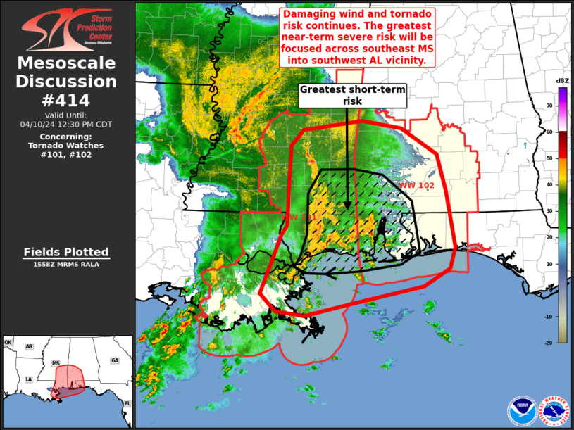
   Mesoscale Discussion 0414
   NWS Storm Prediction Center Norman OK
   1101 AM CDT Wed Apr 10 2024

   Areas affected...far southeast Louisiana...southeast
   Mississippi...southwest Alabama and the western Florida Panhandle

   Concerning...Tornado Watch 101...102...

   Valid 101601Z - 101730Z

   The severe weather threat for Tornado Watch 101, 102 continues.

   SUMMARY...A swath of damaging wind with gusts to 70 mph is possible
   across southeast Mississippi into far southwest Alabama and the
   western Florida Panhandle over the next couple of hours. A couple of
   tornadoes also remain possible.

   DISCUSSION...The line of convection over southeast MS and far
   southeast LA will continue to develop east at around 60 mph. A swath
   of damaging gusts will continue. The corridor of greatest risk over
   the next couple of hours will be focused closer to the coast across
   southeast MS into southwest AL where better low-level moisture and
   instability are noted. This area will also align with more favorable
   effective SRH greater than 300 m2/s2 and STP values around 1-2.
   Furthermore, the MOB VWP indicated an enlarged, and favorably curved
   low-level hodograph. This environment will support tornado
   potential, either via line embedded mesovortex generation or cell
   mergers into the line, as has been observed via radar over the past
   30-60 minutes across southeast LA.

   ..Leitman.. 04/10/2024

   ...Please see www.spc.noaa.gov for graphic product...

   ATTN...WFO...BMX...MOB...JAN...LIX...

   LAT...LON   31538967 32078964 32318942 32478833 32348759 31938694
               31358677 30458661 30118672 29828719 29558851 29368937
               29428990 29719019 30648980 30808970 31538967
|
|
Top/All Mesoscale Discussions/Forecast Products/Home
|
|


 @NWSSPC