 Note:
The expiration time in the watch graphic is amended if the watch is
replaced, cancelled or extended.
Note:
Note:
The expiration time in the watch graphic is amended if the watch is
replaced, cancelled or extended.
Note: Click for
Watch Status Reports.
SEL2
URGENT - IMMEDIATE BROADCAST REQUESTED
Tornado Watch Number 62
NWS Storm Prediction Center Norman OK
650 PM CDT Mon Mar 25 2024
The NWS Storm Prediction Center has issued a
* Tornado Watch for portions of
Southeastern Louisiana
Most of the southern two-thirds of Mississippi
* Effective this Monday night and Tuesday morning from 650 PM
until 200 AM CDT.
* Primary threats include...
A few tornadoes likely with a couple intense tornadoes possible
Scattered damaging wind gusts to 70 mph possible
Isolated large hail events to 1.5 inches in diameter possible
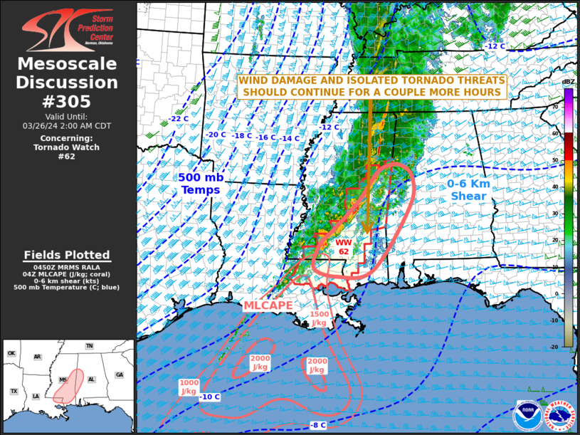
SUMMARY...Strong/locally severe thunderstorms will spread eastward
across the lower Mississippi Valley area and central/southern
Mississippi, along with adjacent portions of Louisiana, over the
next several hours. Damaging wind gusts and a few tornadoes are
expected locally, along with some risk for hail with stronger
storms.
The tornado watch area is approximately along and 70 statute miles
east and west of a line from 85 miles north northwest of Meridian MS
to 40 miles south southwest of Mc Comb MS. For a complete depiction
of the watch see the associated watch outline update (WOUS64 KWNS
WOU2).
PRECAUTIONARY/PREPAREDNESS ACTIONS...
REMEMBER...A Tornado Watch means conditions are favorable for
tornadoes and severe thunderstorms in and close to the watch
area. Persons in these areas should be on the lookout for
threatening weather conditions and listen for later statements
and possible warnings.
&&
OTHER WATCH INFORMATION...CONTINUE...WW 61...
AVIATION...Tornadoes and a few severe thunderstorms with hail
surface and aloft to 1.5 inches. Extreme turbulence and surface wind
gusts to 60 knots. A few cumulonimbi with maximum tops to 45. Mean
storm motion vector 23040.
...Goss
   SEL2

   URGENT - IMMEDIATE BROADCAST REQUESTED
   Tornado Watch Number 62
   NWS Storm Prediction Center Norman OK
   650 PM CDT Mon Mar 25 2024

   The NWS Storm Prediction Center has issued a

   * Tornado Watch for portions of
     Southeastern Louisiana
     Most of the southern two-thirds of Mississippi

   * Effective this Monday night and Tuesday morning from 650 PM
     until 200 AM CDT.

   * Primary threats include...
     A few tornadoes likely with a couple intense tornadoes possible
     Scattered damaging wind gusts to 70 mph possible
     Isolated large hail events to 1.5 inches in diameter possible

   SUMMARY...Strong/locally severe thunderstorms will spread eastward
   across the lower Mississippi Valley area and central/southern
   Mississippi, along with adjacent portions of Louisiana, over the
   next several hours.  Damaging wind gusts and a few tornadoes are
   expected locally, along with some risk for hail with stronger
   storms.

   The tornado watch area is approximately along and 70 statute miles
   east and west of a line from 85 miles north northwest of Meridian MS
   to 40 miles south southwest of Mc Comb MS. For a complete depiction
   of the watch see the associated watch outline update (WOUS64 KWNS
   WOU2).

   PRECAUTIONARY/PREPAREDNESS ACTIONS...

   REMEMBER...A Tornado Watch means conditions are favorable for
   tornadoes and severe thunderstorms in and close to the watch
   area. Persons in these areas should be on the lookout for
   threatening weather conditions and listen for later statements
   and possible warnings.

   &&

   OTHER WATCH INFORMATION...CONTINUE...WW 61...

   AVIATION...Tornadoes and a few severe thunderstorms with hail
   surface and aloft to 1.5 inches. Extreme turbulence and surface wind
   gusts to 60 knots. A few cumulonimbi with maximum tops to 45. Mean
   storm motion vector 23040.

   ...Goss
 Note:
The Aviation Watch (SAW) product is an approximation to the watch area.
The actual watch is depicted by the shaded areas.
Note:
The Aviation Watch (SAW) product is an approximation to the watch area.
The actual watch is depicted by the shaded areas.
   SAW2
   WW 62 TORNADO LA MS 252350Z - 260700Z
   AXIS..70 STATUTE MILES EAST AND WEST OF LINE..
   85NNW MEI/MERIDIAN MS/ - 40SSW MCB/MC COMB MS/
   ..AVIATION COORDS.. 60NM E/W /40W IGB - 31ENE BTR/
   HAIL SURFACE AND ALOFT..1.5 INCHES. WIND GUSTS..60 KNOTS.
   MAX TOPS TO 45. MEAN STORM MOTION VECTOR 23040.

   LAT...LON 33468810 30648955 30649191 33469053

   THIS IS AN APPROXIMATION TO THE WATCH AREA.  FOR A
   COMPLETE DEPICTION OF THE WATCH SEE WOUS64 KWNS
   FOR WOU2.
Watch 62 Status Report Messages:
STATUS REPORT #6 ON WW 62

VALID 260535Z - 260640Z

SEVERE WEATHER THREAT CONTINUES RIGHT OF A LINE FROM 40 E LFT TO
20 SSW MCB TO 30 NNW PIB TO 15 W MEI TO 40 S CBM TO 20 ESE CBM.

..LEITMAN..03/26/24

ATTN...WFO...JAN...LIX...

&&

STATUS REPORT FOR WT 62

SEVERE WEATHER THREAT CONTINUES FOR THE FOLLOWING AREAS

LAC063-103-105-117-260640-

LA
.    LOUISIANA PARISHES INCLUDED ARE

LIVINGSTON	     ST. TAMMANY	 TANGIPAHOA
WASHINGTON
$$


MSC023-031-035-061-065-067-069-073-075-091-103-109-147-260640-

MS
.    MISSISSIPPI COUNTIES INCLUDED ARE

CLARKE		     COVINGTON		 FORREST
JASPER		     JEFFERSON DAVIS	 JONES
KEMPER		     LAMAR		 LAUDERDALE
MARION		     NOXUBEE		 PEARL RIVER
WALTHALL
$$


THE WATCH STATUS MESSAGE IS FOR GUIDANCE PURPOSES ONLY.  PLEASE
REFER TO WATCH COUNTY NOTIFICATION STATEMENTS FOR OFFICIAL
INFORMATION ON COUNTIES...INDEPENDENT CITIES AND MARINE ZONES
CLEARED FROM SEVERE THUNDERSTORM AND TORNADO WATCHES.
$$

STATUS REPORT #5 ON WW 62

VALID 260455Z - 260540Z

SEVERE WEATHER THREAT CONTINUES RIGHT OF A LINE FROM 30 E LFT TO
60 NW PIB TO 45 NW MEI TO 30 W CBM.

..BROYLES..03/26/24

ATTN...WFO...JAN...LIX...

&&

STATUS REPORT FOR WT 62

SEVERE WEATHER THREAT CONTINUES FOR THE FOLLOWING AREAS

LAC033-063-091-103-105-117-121-260540-

LA
.    LOUISIANA PARISHES INCLUDED ARE

EAST BATON ROUGE     LIVINGSTON 	 ST. HELENA
ST. TAMMANY	     TANGIPAHOA 	 WASHINGTON
WEST BATON ROUGE
$$


MSC023-031-035-061-065-067-069-073-075-077-085-087-091-099-101-
103-105-109-113-123-127-129-147-159-260540-

MS
.    MISSISSIPPI COUNTIES INCLUDED ARE

CLARKE		     COVINGTON		 FORREST
JASPER		     JEFFERSON DAVIS	 JONES
KEMPER		     LAMAR		 LAUDERDALE
LAWRENCE	     LINCOLN		 LOWNDES
MARION		     NESHOBA		 NEWTON
NOXUBEE 	     OKTIBBEHA		 PEARL RIVER
PIKE		     SCOTT		 SIMPSON
SMITH		     WALTHALL		 WINSTON
$$


THE WATCH STATUS MESSAGE IS FOR GUIDANCE PURPOSES ONLY.  PLEASE
REFER TO WATCH COUNTY NOTIFICATION STATEMENTS FOR OFFICIAL
INFORMATION ON COUNTIES...INDEPENDENT CITIES AND MARINE ZONES
CLEARED FROM SEVERE THUNDERSTORM AND TORNADO WATCHES.
$$

STATUS REPORT #4 ON WW 62

VALID 260330Z - 260440Z

SEVERE WEATHER THREAT CONTINUES RIGHT OF A LINE FROM 30 ESE ESF
TO 45 ENE HEZ TO 50 SSE GWO TO 30 ENE GWO.

..BROYLES..03/26/24

ATTN...WFO...JAN...LIX...

&&

STATUS REPORT FOR WT 62

SEVERE WEATHER THREAT CONTINUES FOR THE FOLLOWING AREAS

LAC033-037-063-077-091-103-105-117-121-125-260440-

LA
.    LOUISIANA PARISHES INCLUDED ARE

EAST BATON ROUGE     EAST FELICIANA	 LIVINGSTON
POINTE COUPEE	     ST. HELENA 	 ST. TAMMANY
TANGIPAHOA	     WASHINGTON 	 WEST BATON ROUGE
WEST FELICIANA
$$


MSC005-007-019-023-025-029-031-035-037-061-065-067-069-073-075-
077-079-085-087-091-099-101-103-105-109-113-121-123-127-129-147-
157-159-260440-

MS
.    MISSISSIPPI COUNTIES INCLUDED ARE

AMITE		     ATTALA		 CHOCTAW
CLARKE		     CLAY		 COPIAH
COVINGTON	     FORREST		 FRANKLIN
JASPER		     JEFFERSON DAVIS	 JONES
KEMPER		     LAMAR		 LAUDERDALE
LAWRENCE	     LEAKE		 LINCOLN
LOWNDES 	     MARION		 NESHOBA
NEWTON		     NOXUBEE		 OKTIBBEHA
PEARL RIVER	     PIKE		 RANKIN
SCOTT		     SIMPSON		 SMITH
WALTHALL	     WILKINSON		 WINSTON
$$


THE WATCH STATUS MESSAGE IS FOR GUIDANCE PURPOSES ONLY.  PLEASE
REFER TO WATCH COUNTY NOTIFICATION STATEMENTS FOR OFFICIAL
INFORMATION ON COUNTIES...INDEPENDENT CITIES AND MARINE ZONES
CLEARED FROM SEVERE THUNDERSTORM AND TORNADO WATCHES.
$$

STATUS REPORT #3 ON WW 62

VALID 260145Z - 260240Z

THE SEVERE WEATHER THREAT CONTINUES ACROSS THE ENTIRE WATCH AREA.

..BROYLES..03/26/24

ATTN...WFO...JAN...LIX...

&&

STATUS REPORT FOR WT 62

SEVERE WEATHER THREAT CONTINUES FOR THE FOLLOWING AREAS

LAC029-033-037-063-077-091-103-105-117-121-125-260240-

LA
.    LOUISIANA PARISHES INCLUDED ARE

CONCORDIA	     EAST BATON ROUGE	 EAST FELICIANA
LIVINGSTON	     POINTE COUPEE	 ST. HELENA
ST. TAMMANY	     TANGIPAHOA 	 WASHINGTON
WEST BATON ROUGE     WEST FELICIANA
$$


MSC001-005-007-015-019-021-023-025-029-031-035-037-049-051-053-
055-061-063-065-067-069-073-075-077-079-083-085-087-089-091-097-
099-101-103-105-109-113-121-123-125-127-129-147-149-155-157-159-
163-260240-

MS
.    MISSISSIPPI COUNTIES INCLUDED ARE

ADAMS		     AMITE		 ATTALA
CARROLL 	     CHOCTAW		 CLAIBORNE
CLARKE		     CLAY		 COPIAH
COVINGTON	     FORREST		 FRANKLIN
HINDS		     HOLMES		 HUMPHREYS
ISSAQUENA	     JASPER		 JEFFERSON
JEFFERSON DAVIS      JONES		 KEMPER
LAMAR		     LAUDERDALE 	 LAWRENCE
LEAKE		     LEFLORE		 LINCOLN
LOWNDES 	     MADISON		 MARION
MONTGOMERY	     NESHOBA		 NEWTON
NOXUBEE 	     OKTIBBEHA		 PEARL RIVER
PIKE		     RANKIN		 SCOTT
SHARKEY 	     SIMPSON		 SMITH
WALTHALL	     WARREN		 WEBSTER
WILKINSON	     WINSTON		 YAZOO
$$


THE WATCH STATUS MESSAGE IS FOR GUIDANCE PURPOSES ONLY.  PLEASE
REFER TO WATCH COUNTY NOTIFICATION STATEMENTS FOR OFFICIAL
INFORMATION ON COUNTIES...INDEPENDENT CITIES AND MARINE ZONES
CLEARED FROM SEVERE THUNDERSTORM AND TORNADO WATCHES.
$$

STATUS REPORT #2 ON WW 62

VALID 260030Z - 260140Z

THE SEVERE WEATHER THREAT CONTINUES ACROSS THE ENTIRE WATCH AREA.

..BROYLES..03/26/24

ATTN...WFO...JAN...LIX...

&&

STATUS REPORT FOR WT 62

SEVERE WEATHER THREAT CONTINUES FOR THE FOLLOWING AREAS

LAC029-033-037-063-077-091-103-105-117-121-125-260140-

LA
.    LOUISIANA PARISHES INCLUDED ARE

CONCORDIA	     EAST BATON ROUGE	 EAST FELICIANA
LIVINGSTON	     POINTE COUPEE	 ST. HELENA
ST. TAMMANY	     TANGIPAHOA 	 WASHINGTON
WEST BATON ROUGE     WEST FELICIANA
$$


MSC001-005-007-015-019-021-023-025-029-031-035-037-049-051-053-
055-061-063-065-067-069-073-075-077-079-083-085-087-089-091-097-
099-101-103-105-109-113-121-123-125-127-129-147-149-155-157-159-
163-260140-

MS
.    MISSISSIPPI COUNTIES INCLUDED ARE

ADAMS		     AMITE		 ATTALA
CARROLL 	     CHOCTAW		 CLAIBORNE
CLARKE		     CLAY		 COPIAH
COVINGTON	     FORREST		 FRANKLIN
HINDS		     HOLMES		 HUMPHREYS
ISSAQUENA	     JASPER		 JEFFERSON
JEFFERSON DAVIS      JONES		 KEMPER
LAMAR		     LAUDERDALE 	 LAWRENCE
LEAKE		     LEFLORE		 LINCOLN
LOWNDES 	     MADISON		 MARION
MONTGOMERY	     NESHOBA		 NEWTON
NOXUBEE 	     OKTIBBEHA		 PEARL RIVER
PIKE		     RANKIN		 SCOTT
SHARKEY 	     SIMPSON		 SMITH
WALTHALL	     WARREN		 WEBSTER
WILKINSON	     WINSTON		 YAZOO
$$


THE WATCH STATUS MESSAGE IS FOR GUIDANCE PURPOSES ONLY.  PLEASE
REFER TO WATCH COUNTY NOTIFICATION STATEMENTS FOR OFFICIAL
INFORMATION ON COUNTIES...INDEPENDENT CITIES AND MARINE ZONES
CLEARED FROM SEVERE THUNDERSTORM AND TORNADO WATCHES.
$$

STATUS REPORT #1 ON WW 62

VALID 260015Z - 260140Z

THE SEVERE WEATHER THREAT CONTINUES ACROSS THE ENTIRE WATCH AREA.

..BROYLES..03/26/24

ATTN...WFO...JAN...LIX...

&&

STATUS REPORT FOR WT 62

SEVERE WEATHER THREAT CONTINUES FOR THE FOLLOWING AREAS

LAC029-033-037-063-077-091-103-105-117-121-125-260140-

LA
.    LOUISIANA PARISHES INCLUDED ARE

CONCORDIA	     EAST BATON ROUGE	 EAST FELICIANA
LIVINGSTON	     POINTE COUPEE	 ST. HELENA
ST. TAMMANY	     TANGIPAHOA 	 WASHINGTON
WEST BATON ROUGE     WEST FELICIANA
$$


MSC001-005-007-015-019-021-023-025-029-031-035-037-049-051-053-
055-061-063-065-067-069-073-075-077-079-083-085-087-089-091-097-
099-101-103-105-109-113-121-123-125-127-129-147-149-155-157-159-
163-260140-

MS
.    MISSISSIPPI COUNTIES INCLUDED ARE

ADAMS		     AMITE		 ATTALA
CARROLL 	     CHOCTAW		 CLAIBORNE
CLARKE		     CLAY		 COPIAH
COVINGTON	     FORREST		 FRANKLIN
HINDS		     HOLMES		 HUMPHREYS
ISSAQUENA	     JASPER		 JEFFERSON
JEFFERSON DAVIS      JONES		 KEMPER
LAMAR		     LAUDERDALE 	 LAWRENCE
LEAKE		     LEFLORE		 LINCOLN
LOWNDES 	     MADISON		 MARION
MONTGOMERY	     NESHOBA		 NEWTON
NOXUBEE 	     OKTIBBEHA		 PEARL RIVER
PIKE		     RANKIN		 SCOTT
SHARKEY 	     SIMPSON		 SMITH
WALTHALL	     WARREN		 WEBSTER
WILKINSON	     WINSTON		 YAZOO
$$


THE WATCH STATUS MESSAGE IS FOR GUIDANCE PURPOSES ONLY.  PLEASE
REFER TO WATCH COUNTY NOTIFICATION STATEMENTS FOR OFFICIAL
INFORMATION ON COUNTIES...INDEPENDENT CITIES AND MARINE ZONES
CLEARED FROM SEVERE THUNDERSTORM AND TORNADO WATCHES.
$$
Note:
Click for Complete Product Text.
Tornadoes
Probability of 2 or more tornadoes
|
Mod (60%)
|
Probability of 1 or more strong (EF2-EF5) tornadoes
|
Mod (50%)
|
Wind
Probability of 10 or more severe wind events
|
Mod (50%)
|
Probability of 1 or more wind events > 65 knots
|
Low (20%)
|
Hail
Probability of 10 or more severe hail events
|
Low (20%)
|
Probability of 1 or more hailstones > 2 inches
|
Low (10%)
|
Combined Severe Hail/Wind
Probability of 6 or more combined severe hail/wind events
|
High (70%)
|
For each watch, probabilities for particular events inside the watch
(listed above in each table) are determined by the issuing forecaster.
The "Low" category contains probability values ranging from less than 2%
to 20% (EF2-EF5 tornadoes), less than 5% to 20% (all other probabilities),
"Moderate" from 30% to 60%, and "High" from 70% to greater than 95%.
High values are bolded and lighter in color to provide awareness of
an increased threat for a particular event.


 @NWSSPC