|
| Mesoscale Discussion 305 |
|
< Previous MD Next MD >
|
|
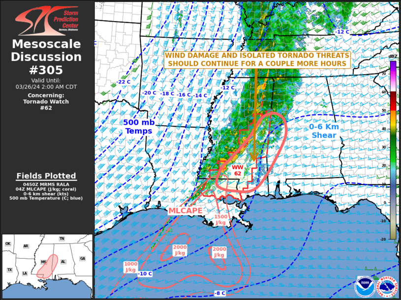
   Mesoscale Discussion 0305
   NWS Storm Prediction Center Norman OK
   1153 PM CDT Mon Mar 25 2024

   Areas affected...Mississippi...Western Alabama...Far Eastern
   Louisiana

   Concerning...Tornado Watch 62...

   Valid 260453Z - 260700Z

   The severe weather threat for Tornado Watch 62 continues.

   SUMMARY...A wind damage and isolated tornado threat is expected to
   continue for a couple more hours across parts of eastern and
   south-central Mississippi. Weather watch issuance may be needed
   later tonight in parts of far southern Mississippi and southern
   Alabama.

   DISCUSSION...The latest mosaic radar imagery shows a linear MCS
   ongoing from east-central into southern Mississippi, with a few
   embedded strong to severe storms. The northern half of the line is
   in very weak instability with the RAP showing MLCAPE generally below
   250 J/kg. An isolated wind-damage threat may persist before the
   northern part of the line moves into western Alabama, where the
   airmass is relatively stable. Farther to the south-southwest, the
   airmass is more unstable across parts of southeastern Mississippi,
   with the RAP suggesting MLCAPE is in the 500 to 1000 J/kg range. In
   addition, RAP forecast soundings after midnight in southeast
   Mississippi have 0-6 km shear near 65 knots, with 0-3 km
   storm-relative helicity around 500 m2/s2. As the line moves eastward
   across southeast Mississippi over the next few hours, this
   environment could support an isolated tornado threat. Damaging wind
   gusts will also be possible with the more intense sections of the
   line.

   ..Broyles.. 03/26/2024

   ...Please see www.spc.noaa.gov for graphic product...

   ATTN...WFO...BMX...MOB...JAN...LIX...

   LAT...LON   33368874 32598932 31849008 31389055 30769072 30538997
               30718886 32458768 33258761 33568799 33578831 33368874
|
|
Top/All Mesoscale Discussions/Forecast Products/Home
|
|


 @NWSSPC