Note:
The expiration time in the watch graphic is amended if the watch is
replaced, cancelled or extended.
Note:
Note:
The expiration time in the watch graphic is amended if the watch is
replaced, cancelled or extended.
Note: Click for
Watch Status Reports.
SEL1
URGENT - IMMEDIATE BROADCAST REQUESTED
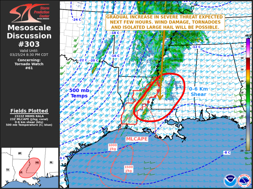
Tornado Watch Number 61
NWS Storm Prediction Center Norman OK
145 PM CDT Mon Mar 25 2024
The NWS Storm Prediction Center has issued a
* Tornado Watch for portions of
Southeast Arkansas
Western and Northern Louisiana
Southeast Texas
* Effective this Monday afternoon and evening from 145 PM until
800 PM CDT.
* Primary threats include...
A few tornadoes likely with a couple intense tornadoes possible
Scattered damaging wind gusts to 70 mph likely
Isolated large hail events to 1.5 inches in diameter possible
SUMMARY...Thunderstorms are beginning to intensify over southeast
Texas and western Louisiana ahead of a cold front. Strong winds
aloft will pose a risk of a few severe storms capable of damaging
winds and a few tornadoes through the afternoon.
The tornado watch area is approximately along and 65 statute miles
east and west of a line from 65 miles south southwest of Fort Polk
LA to 60 miles east northeast of El Dorado AR. For a complete
depiction of the watch see the associated watch outline update
(WOUS64 KWNS WOU1).
PRECAUTIONARY/PREPAREDNESS ACTIONS...
REMEMBER...A Tornado Watch means conditions are favorable for
tornadoes and severe thunderstorms in and close to the watch
area. Persons in these areas should be on the lookout for
threatening weather conditions and listen for later statements
and possible warnings.
&&
AVIATION...Tornadoes and a few severe thunderstorms with hail
surface and aloft to 1.5 inches. Extreme turbulence and surface wind
gusts to 60 knots. A few cumulonimbi with maximum tops to 500. Mean
storm motion vector 24035.
...Hart
 Note:
The Aviation Watch (SAW) product is an approximation to the watch area.
The actual watch is depicted by the shaded areas.
Note:
The Aviation Watch (SAW) product is an approximation to the watch area.
The actual watch is depicted by the shaded areas.
   SAW1
   WW 61 TORNADO AR LA TX 251845Z - 260100Z
   AXIS..65 STATUTE MILES EAST AND WEST OF LINE..
   65SSW POE/FORT POLK LA/ - 60ENE ELD/EL DORADO AR/
   ..AVIATION COORDS.. 55NM E/W /25W LCH - 48ENE ELD/
   HAIL SURFACE AND ALOFT..1.5 INCHES. WIND GUSTS..60 KNOTS.
   MAX TOPS TO 500. MEAN STORM MOTION VECTOR 24035.

   LAT...LON 30189468 33549299 33549073 30189251

   THIS IS AN APPROXIMATION TO THE WATCH AREA.  FOR A
   COMPLETE DEPICTION OF THE WATCH SEE WOUS64 KWNS
   FOR WOU1.
Watch 61 Status Report Messages:
STATUS REPORT #3 ON WW 61

VALID 260035Z - 260140Z

SEVERE WEATHER THREAT CONTINUES RIGHT OF A LINE FROM 35 SSW LCH
TO 35 NNE ESF TO 15 ESE GLH.

..BROYLES..03/26/24

ATTN...WFO...JAN...LZK...SHV...LCH...

&&

STATUS REPORT FOR WT 61

SEVERE WEATHER THREAT CONTINUES FOR THE FOLLOWING AREAS

LAC003-025-035-041-053-059-065-079-107-260140-

LA
.    LOUISIANA PARISHES INCLUDED ARE

ALLEN		     CATAHOULA		 EAST CARROLL
FRANKLIN	     JEFFERSON DAVIS	 LA SALLE
MADISON 	     RAPIDES		 TENSAS
$$


THE WATCH STATUS MESSAGE IS FOR GUIDANCE PURPOSES ONLY.  PLEASE
REFER TO WATCH COUNTY NOTIFICATION STATEMENTS FOR OFFICIAL
INFORMATION ON COUNTIES...INDEPENDENT CITIES AND MARINE ZONES
CLEARED FROM SEVERE THUNDERSTORM AND TORNADO WATCHES.
$$

STATUS REPORT #2 ON WW 61

VALID 260015Z - 260140Z

SEVERE WEATHER THREAT CONTINUES RIGHT OF A LINE FROM 10 SW LCH TO
35 NNE LCH TO 25 N ESF TO 20 ENE GLH.

..BROYLES..03/26/24

ATTN...WFO...JAN...LZK...SHV...LCH...

&&

STATUS REPORT FOR WT 61

SEVERE WEATHER THREAT CONTINUES FOR THE FOLLOWING AREAS

LAC003-025-035-041-053-059-065-079-107-260140-

LA
.    LOUISIANA PARISHES INCLUDED ARE

ALLEN		     CATAHOULA		 EAST CARROLL
FRANKLIN	     JEFFERSON DAVIS	 LA SALLE
MADISON 	     RAPIDES		 TENSAS
$$


THE WATCH STATUS MESSAGE IS FOR GUIDANCE PURPOSES ONLY.  PLEASE
REFER TO WATCH COUNTY NOTIFICATION STATEMENTS FOR OFFICIAL
INFORMATION ON COUNTIES...INDEPENDENT CITIES AND MARINE ZONES
CLEARED FROM SEVERE THUNDERSTORM AND TORNADO WATCHES.
$$

STATUS REPORT #1 ON WW 61

VALID 252040Z - 252140Z

SEVERE WEATHER THREAT CONTINUES RIGHT OF A LINE FROM 45 WNW BPT
TO 50 SE LFK TO 45 WNW POE TO IER TO 15 W MLU TO 30 SSW LLQ TO 10
SSW LLQ.

..KERR..03/25/24

ATTN...WFO...JAN...LZK...SHV...LCH...

&&

STATUS REPORT FOR WT 61

SEVERE WEATHER THREAT CONTINUES FOR THE FOLLOWING AREAS

ARC003-017-043-252140-

AR
.    ARKANSAS COUNTIES INCLUDED ARE

ASHLEY		     CHICOT		 DREW
$$


LAC003-011-019-021-025-035-041-043-049-053-059-065-067-069-073-
079-083-107-115-123-127-252140-

LA
.    LOUISIANA PARISHES INCLUDED ARE

ALLEN		     BEAUREGARD 	 CALCASIEU
CALDWELL	     CATAHOULA		 EAST CARROLL
FRANKLIN	     GRANT		 JACKSON
JEFFERSON DAVIS      LA SALLE		 MADISON
MOREHOUSE	     NATCHITOCHES	 OUACHITA
RAPIDES 	     RICHLAND		 TENSAS
VERNON		     WEST CARROLL	 WINN
$$


TXC199-241-351-361-403-252140-

TX
.    TEXAS COUNTIES INCLUDED ARE

HARDIN		     JASPER		 NEWTON
ORANGE		     SABINE
$$


THE WATCH STATUS MESSAGE IS FOR GUIDANCE PURPOSES ONLY.  PLEASE
REFER TO WATCH COUNTY NOTIFICATION STATEMENTS FOR OFFICIAL
INFORMATION ON COUNTIES...INDEPENDENT CITIES AND MARINE ZONES
CLEARED FROM SEVERE THUNDERSTORM AND TORNADO WATCHES.
$$
Note:
Click for Complete Product Text.
Tornadoes
Probability of 2 or more tornadoes
|
Mod (60%)
|
Probability of 1 or more strong (EF2-EF5) tornadoes
|
Mod (40%)
|
Wind
Probability of 10 or more severe wind events
|
Mod (60%)
|
Probability of 1 or more wind events > 65 knots
|
Low (20%)
|
Hail
Probability of 10 or more severe hail events
|
Low (20%)
|
Probability of 1 or more hailstones > 2 inches
|
Low (10%)
|
Combined Severe Hail/Wind
Probability of 6 or more combined severe hail/wind events
|
High (80%)
|
For each watch, probabilities for particular events inside the watch
(listed above in each table) are determined by the issuing forecaster.
The "Low" category contains probability values ranging from less than 2%
to 20% (EF2-EF5 tornadoes), less than 5% to 20% (all other probabilities),
"Moderate" from 30% to 60%, and "High" from 70% to greater than 95%.
High values are bolded and lighter in color to provide awareness of
an increased threat for a particular event.


 @NWSSPC