 Note:
The expiration time in the watch graphic is amended if the watch is
replaced, cancelled or extended.
Note:
Note:
The expiration time in the watch graphic is amended if the watch is
replaced, cancelled or extended.
Note: Click for
Watch Status Reports.
SEL9
URGENT - IMMEDIATE BROADCAST REQUESTED
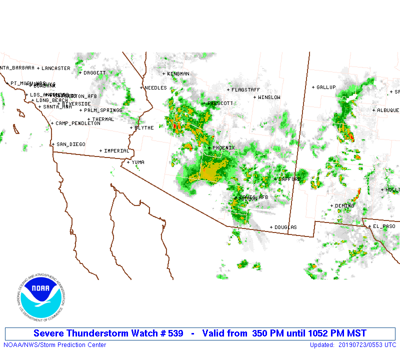
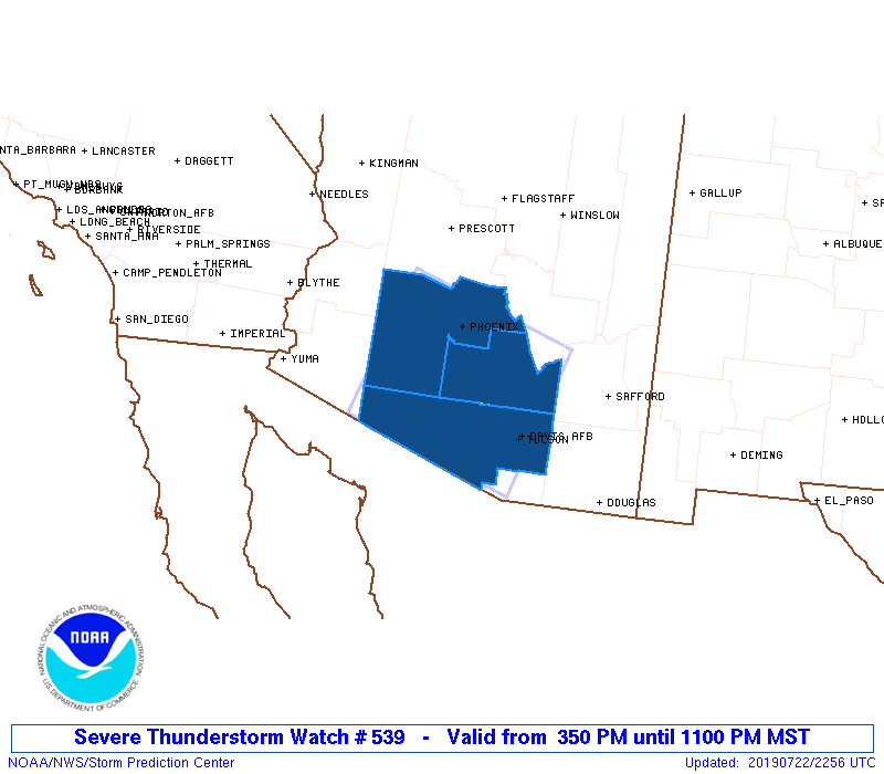
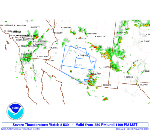
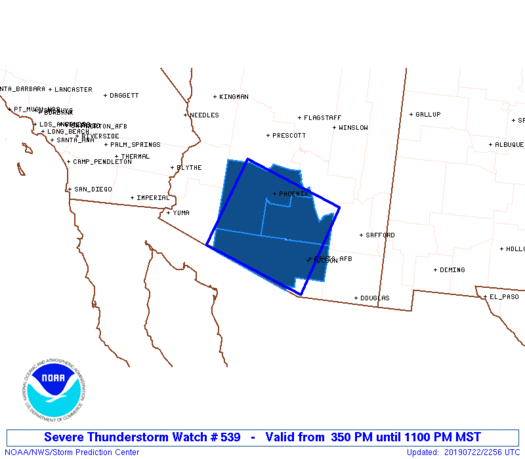
Severe Thunderstorm Watch Number 539
NWS Storm Prediction Center Norman OK
350 PM MST Mon Jul 22 2019
The NWS Storm Prediction Center has issued a
* Severe Thunderstorm Watch for portions of
Southern Arizona
* Effective this Monday afternoon and evening from 350 PM until
1100 PM MST.
* Primary threats include...
Scattered damaging winds and isolated significant gusts to 75
mph possible
SUMMARY...One or two primary bands of thunderstorms are expected to
move westward to northwestward across the watch area through the
evening, offering the threat of severe gusts. Isolated cells ahead
of the complex(es) also can produce localized severe downbursts.
The severe thunderstorm watch area is approximately along and 70
statute miles either side of a line from 25 miles northeast of
Tucson AZ to 30 miles west northwest of Gila Bend AZ. For a complete
depiction of the watch see the associated watch outline update
(WOUS64 KWNS WOU9).
PRECAUTIONARY/PREPAREDNESS ACTIONS...
REMEMBER...A Severe Thunderstorm Watch means conditions are
favorable for severe thunderstorms in and close to the watch area.
Persons in these areas should be on the lookout for threatening
weather conditions and listen for later statements and possible
warnings. Severe thunderstorms can and occasionally do produce
tornadoes.
&&
OTHER WATCH INFORMATION...CONTINUE...WW 538...
AVIATION...A few severe thunderstorms with hail surface and aloft to
0.5 inches. Extreme turbulence and surface wind gusts to 65 knots. A
few cumulonimbi with maximum tops to 550. Mean storm motion vector
12035.
...Edwards

   SEL9

   URGENT - IMMEDIATE BROADCAST REQUESTED
   Severe Thunderstorm Watch Number 539
   NWS Storm Prediction Center Norman OK
   350 PM MST Mon Jul 22 2019

   The NWS Storm Prediction Center has issued a

   * Severe Thunderstorm Watch for portions of
     Southern Arizona

   * Effective this Monday afternoon and evening from 350 PM until
     1100 PM MST.

   * Primary threats include...
     Scattered damaging winds and isolated significant gusts to 75
       mph possible

   SUMMARY...One or two primary bands of thunderstorms are expected to
   move westward to northwestward across the watch area through the
   evening, offering the threat of severe gusts.  Isolated cells ahead
   of the complex(es) also can produce localized severe downbursts.

   The severe thunderstorm watch area is approximately along and 70
   statute miles either side of a line from 25 miles northeast of
   Tucson AZ to 30 miles west northwest of Gila Bend AZ. For a complete
   depiction of the watch see the associated watch outline update
   (WOUS64 KWNS WOU9).

   PRECAUTIONARY/PREPAREDNESS ACTIONS...

   REMEMBER...A Severe Thunderstorm Watch means conditions are
   favorable for severe thunderstorms in and close to the watch area.
   Persons in these areas should be on the lookout for threatening
   weather conditions and listen for later statements and possible
   warnings. Severe thunderstorms can and occasionally do produce
   tornadoes.

   &&

   OTHER WATCH INFORMATION...CONTINUE...WW 538...

   AVIATION...A few severe thunderstorms with hail surface and aloft to
   0.5 inches. Extreme turbulence and surface wind gusts to 65 knots. A
   few cumulonimbi with maximum tops to 550. Mean storm motion vector
   12035.

   ...Edwards
 Note:
The Aviation Watch (SAW) product is an approximation to the watch area.
The actual watch is depicted by the shaded areas.
Note:
The Aviation Watch (SAW) product is an approximation to the watch area.
The actual watch is depicted by the shaded areas.
   SAW9
   WW 539 SEVERE TSTM AZ 222250Z - 230600Z
   AXIS..70 STATUTE MILES EITHER SIDE OF LINE..
   25NE TUS/TUCSON AZ/ - 30WNW GBN/GILA BEND AZ/
   ..AVIATION COORDS.. 60NM EITHER SIDE /21NE TUS - 62WSW PHX/
   HAIL SURFACE AND ALOFT..0.5 INCH. WIND GUSTS..65 KNOTS.
   MAX TOPS TO 550. MEAN STORM MOTION VECTOR 12035.

   LAT...LON 31391100 32131354 34061280 33331027

   THIS IS AN APPROXIMATION TO THE WATCH AREA.  FOR A
   COMPLETE DEPICTION OF THE WATCH SEE WOUS64 KWNS
   FOR WOU9.
Watch 539 Status Report Messages:
STATUS REPORT #5 ON WW 539

VALID 230435Z - 230540Z

SEVERE WEATHER THREAT CONTINUES RIGHT OF A LINE FROM 30 NNE PHX
TO 15 ESE PHX TO 20 SE GBN TO 55 E YUM.

..LEITMAN..07/23/19

ATTN...WFO...PSR...TWC...

&&

STATUS REPORT FOR WS 539

SEVERE WEATHER THREAT CONTINUES FOR THE FOLLOWING AREAS

AZC013-230540-

AZ
.    ARIZONA COUNTIES INCLUDED ARE

MARICOPA
$$


THE WATCH STATUS MESSAGE IS FOR GUIDANCE PURPOSES ONLY.  PLEASE
REFER TO WATCH COUNTY NOTIFICATION STATEMENTS FOR OFFICIAL
INFORMATION ON COUNTIES...INDEPENDENT CITIES AND MARINE ZONES
CLEARED FROM SEVERE THUNDERSTORM AND TORNADO WATCHES.
$$

STATUS REPORT #4 ON WW 539

VALID 230345Z - 230440Z

SEVERE WEATHER THREAT CONTINUES RIGHT OF A LINE FROM 50 NNE PHX
TO 40 N TUS TO 60 SE GBN TO 85 S GBN.

..LEITMAN..07/23/19

ATTN...WFO...PSR...TWC...

&&

STATUS REPORT FOR WS 539

SEVERE WEATHER THREAT CONTINUES FOR THE FOLLOWING AREAS

AZC013-019-021-230440-

AZ
.    ARIZONA COUNTIES INCLUDED ARE

MARICOPA	     PIMA		 PINAL
$$


THE WATCH STATUS MESSAGE IS FOR GUIDANCE PURPOSES ONLY.  PLEASE
REFER TO WATCH COUNTY NOTIFICATION STATEMENTS FOR OFFICIAL
INFORMATION ON COUNTIES...INDEPENDENT CITIES AND MARINE ZONES
CLEARED FROM SEVERE THUNDERSTORM AND TORNADO WATCHES.
$$

STATUS REPORT #3 ON WW 539

VALID 230210Z - 230340Z

SEVERE WEATHER THREAT CONTINUES RIGHT OF A LINE FROM 35 E TUS TO
15 WSW TUS TO 60 W TUS TO 80 S GBN.

FOR ADDITIONAL INFORMATION SEE MESOSCALE DISCUSSION 1577

..BENTLEY..07/23/19

ATTN...WFO...PSR...TWC...

&&

STATUS REPORT FOR WS 539

SEVERE WEATHER THREAT CONTINUES FOR THE FOLLOWING AREAS

AZC013-019-021-230340-

AZ
.    ARIZONA COUNTIES INCLUDED ARE

MARICOPA	     PIMA		 PINAL
$$


THE WATCH STATUS MESSAGE IS FOR GUIDANCE PURPOSES ONLY.  PLEASE
REFER TO WATCH COUNTY NOTIFICATION STATEMENTS FOR OFFICIAL
INFORMATION ON COUNTIES...INDEPENDENT CITIES AND MARINE ZONES
CLEARED FROM SEVERE THUNDERSTORM AND TORNADO WATCHES.
$$

STATUS REPORT #2 ON WW 539

VALID 230040Z - 230140Z

SEVERE WEATHER THREAT CONTINUES RIGHT OF A LINE FROM 10 N FHU TO
40 SW TUS TO 85 WSW TUS.

..BENTLEY..07/23/19

ATTN...WFO...PSR...TWC...

&&

STATUS REPORT FOR WS 539

SEVERE WEATHER THREAT CONTINUES FOR THE FOLLOWING AREAS

AZC013-019-021-230140-

AZ
.    ARIZONA COUNTIES INCLUDED ARE

MARICOPA	     PIMA		 PINAL
$$


THE WATCH STATUS MESSAGE IS FOR GUIDANCE PURPOSES ONLY.  PLEASE
REFER TO WATCH COUNTY NOTIFICATION STATEMENTS FOR OFFICIAL
INFORMATION ON COUNTIES...INDEPENDENT CITIES AND MARINE ZONES
CLEARED FROM SEVERE THUNDERSTORM AND TORNADO WATCHES.
$$

STATUS REPORT #1 ON WW 539

VALID 222350Z - 230040Z

THE SEVERE WEATHER THREAT CONTINUES ACROSS THE ENTIRE WATCH AREA.

..BENTLEY..07/22/19

ATTN...WFO...PSR...TWC...

&&

STATUS REPORT FOR WS 539

SEVERE WEATHER THREAT CONTINUES FOR THE FOLLOWING AREAS

AZC013-019-021-230040-

AZ
.    ARIZONA COUNTIES INCLUDED ARE

MARICOPA	     PIMA		 PINAL
$$


THE WATCH STATUS MESSAGE IS FOR GUIDANCE PURPOSES ONLY.  PLEASE
REFER TO WATCH COUNTY NOTIFICATION STATEMENTS FOR OFFICIAL
INFORMATION ON COUNTIES...INDEPENDENT CITIES AND MARINE ZONES
CLEARED FROM SEVERE THUNDERSTORM AND TORNADO WATCHES.
$$
Note:
Click for Complete Product Text.
Tornadoes
Probability of 2 or more tornadoes
|
Low (<5%)
|
Probability of 1 or more strong (EF2-EF5) tornadoes
|
Low (<2%)
|
Wind
Probability of 10 or more severe wind events
|
Mod (40%)
|
Probability of 1 or more wind events > 65 knots
|
Mod (30%)
|
Hail
Probability of 10 or more severe hail events
|
Low (<5%)
|
Probability of 1 or more hailstones > 2 inches
|
Low (<5%)
|
Combined Severe Hail/Wind
Probability of 6 or more combined severe hail/wind events
|
Mod (50%)
|
For each watch, probabilities for particular events inside the watch
(listed above in each table) are determined by the issuing forecaster.
The "Low" category contains probability values ranging from less than 2%
to 20% (EF2-EF5 tornadoes), less than 5% to 20% (all other probabilities),
"Moderate" from 30% to 60%, and "High" from 70% to greater than 95%.
High values are bolded and lighter in color to provide awareness of
an increased threat for a particular event.


 @NWSSPC