|
| Mesoscale Discussion 1578 |
|
< Previous MD Next MD >
|
|
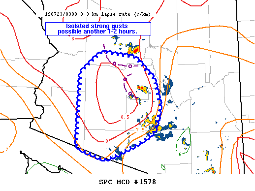
   Mesoscale Discussion 1578
   NWS Storm Prediction Center Norman OK
   1102 PM CDT Mon Jul 22 2019

   Areas affected...portions of southern AZ

   Concerning...Severe Thunderstorm Watch 539...

   Valid 230402Z - 230530Z

   The severe weather threat for Severe Thunderstorm Watch 539
   continues.

   SUMMARY...Additional strong to severe gusts are possible across
   western portions of WW 539 over the next 1-2 hours.

   DISCUSSION...Most recent measured surface gusts in the watch area
   have ranged from 38 to 44 kt. There has been some increase in in
   thunderstorm intensity near Phoenix behind a westward-surging
   outflow boundary. Some gusty winds will remain possible as steep
   low-level lapse rates remain downstream of ongoing convection.
   Another outflow boundary was noted surging southward from Yavapai
   County into northern Maricopa County.  These two boundaries could
   lead to additional convection as they collide and further strong to
   severe winds could result and spread across central and western
   portions of Maricopa County over the next hour or two. Where storms
   and outflow have already occurred across eastern portions of the
   watch, additional severe gusts are not expected.

   ..Leitman.. 07/23/2019

   ...Please see www.spc.noaa.gov for graphic product...

   ATTN...WFO...TWC...FGZ...PSR...

   LAT...LON   33811345 34281289 34171196 33681144 33031128 32491143
               32261176 31931249 31831279 32101351 33811345
|
|
Top/All Mesoscale Discussions/Forecast Products/Home
|
|


 @NWSSPC