Note:
The expiration time in the watch graphic is amended if the watch is
replaced, cancelled or extended.
Note:
Note:
The expiration time in the watch graphic is amended if the watch is
replaced, cancelled or extended.
Note: Click for
Watch Status Reports.
SEL8
0-230200-
URGENT - IMMEDIATE BROADCAST REQUESTED
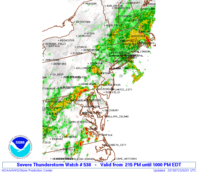
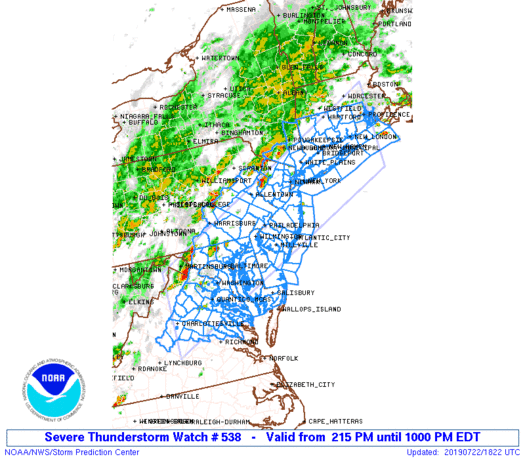
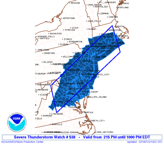
Severe Thunderstorm Watch Number 538
NWS Storm Prediction Center Norman OK
215 PM EDT Mon Jul 22 2019
The NWS Storm Prediction Center has issued a
* Severe Thunderstorm Watch for portions of
Connecticut
District Of Columbia
Delaware
Eastern Maryland
New Jersey
Southern New York
Southeast Pennsylvania
Rhode Island
Eastern Virginia
Coastal Waters
* Effective this Monday afternoon and evening from 215 PM until
1000 PM EDT.
* Primary threats include...
Scattered damaging wind gusts to 70 mph likely
A tornado or two possible
SUMMARY...Scattered thunderstorms will continue to develop and
intensify within a moist/moderately unstable air mass to the east of
a cold front. Winds aloft should be sufficient for organized
multicells, with a couple of transient supercells also possible.
Damaging winds are the most likely risk as storms progress
east-northeastward through late afternoon and evening.
The severe thunderstorm watch area is approximately along and 70
statute miles north and south of a line from 15 miles north
northwest of Charlottesville VA to 20 miles south southeast of
Providence RI. For a complete depiction of the watch see the
associated watch outline update (WOUS64 KWNS WOU8).
PRECAUTIONARY/PREPAREDNESS ACTIONS...
REMEMBER...A Severe Thunderstorm Watch means conditions are
favorable for severe thunderstorms in and close to the watch area.
Persons in these areas should be on the lookout for threatening
weather conditions and listen for later statements and possible
warnings. Severe thunderstorms can and occasionally do produce
tornadoes.
&&
AVIATION...A few severe thunderstorms with hail surface and aloft to
1 inch. Extreme turbulence and surface wind gusts to 60 knots. A few
cumulonimbi with maximum tops to 500. Mean storm motion vector
24025.
...Guyer
   SEL8
   0-230200-

   URGENT - IMMEDIATE BROADCAST REQUESTED
   Severe Thunderstorm Watch Number 538
   NWS Storm Prediction Center Norman OK
   215 PM EDT Mon Jul 22 2019

   The NWS Storm Prediction Center has issued a

   * Severe Thunderstorm Watch for portions of
     Connecticut
     District Of Columbia
     Delaware
     Eastern Maryland
     New Jersey
     Southern New York
     Southeast Pennsylvania
     Rhode Island
     Eastern Virginia
     Coastal Waters

   * Effective this Monday afternoon and evening from 215 PM until
     1000 PM EDT.

   * Primary threats include...
     Scattered damaging wind gusts to 70 mph likely
     A tornado or two possible

   SUMMARY...Scattered thunderstorms will continue to develop and
   intensify within a moist/moderately unstable air mass to the east of
   a cold front. Winds aloft should be sufficient for organized
   multicells, with a couple of transient supercells also possible.
   Damaging winds are the most likely risk as storms progress
   east-northeastward through late afternoon and evening.

   The severe thunderstorm watch area is approximately along and 70
   statute miles north and south of a line from 15 miles north
   northwest of Charlottesville VA to 20 miles south southeast of
   Providence RI. For a complete depiction of the watch see the
   associated watch outline update (WOUS64 KWNS WOU8).

   PRECAUTIONARY/PREPAREDNESS ACTIONS...

   REMEMBER...A Severe Thunderstorm Watch means conditions are
   favorable for severe thunderstorms in and close to the watch area.
   Persons in these areas should be on the lookout for threatening
   weather conditions and listen for later statements and possible
   warnings. Severe thunderstorms can and occasionally do produce
   tornadoes.

   &&

   AVIATION...A few severe thunderstorms with hail surface and aloft to
   1 inch. Extreme turbulence and surface wind gusts to 60 knots. A few
   cumulonimbi with maximum tops to 500. Mean storm motion vector
   24025.

   ...Guyer
 Note:
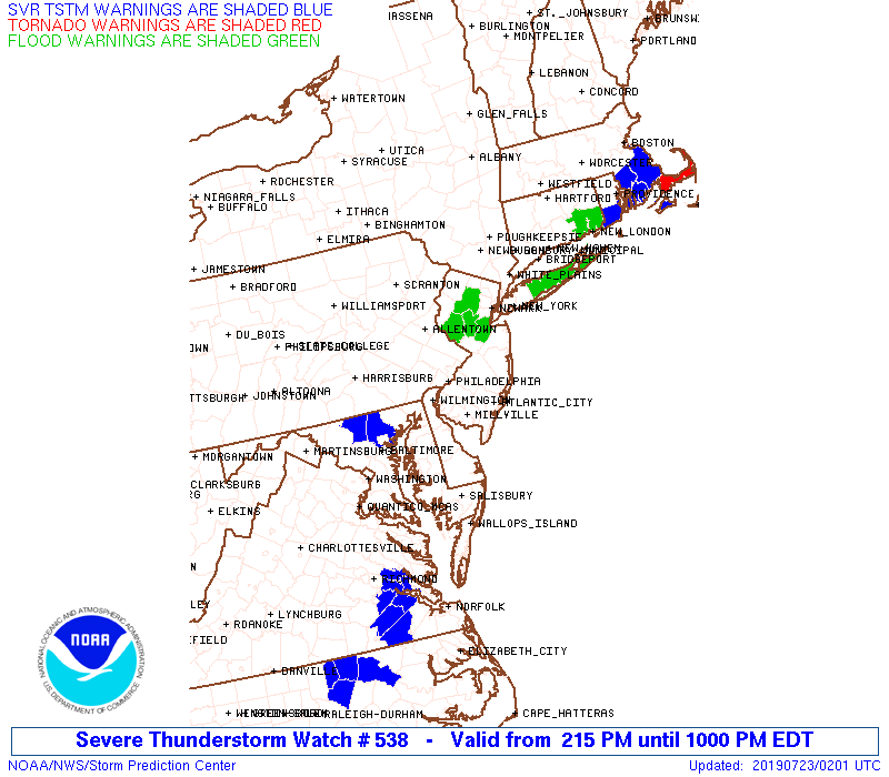
The Aviation Watch (SAW) product is an approximation to the watch area.
The actual watch is depicted by the shaded areas.
Note:
The Aviation Watch (SAW) product is an approximation to the watch area.
The actual watch is depicted by the shaded areas.
   SAW8
   WW 538 SEVERE TSTM CT DC DE MD NJ NY PA RI VA CW 221815Z - 230200Z
   AXIS..70 STATUTE MILES NORTH AND SOUTH OF LINE..
   15NNW CHO/CHARLOTTESVILLE VA/ - 20SSE PVD/PROVIDENCE RI/
   ..AVIATION COORDS.. 60NM N/S /37WSW CSN - 17SSE PVD/
   HAIL SURFACE AND ALOFT..1 INCH. WIND GUSTS..60 KNOTS.
   MAX TOPS TO 500. MEAN STORM MOTION VECTOR 24025.

   LAT...LON 39347855 42477127 40457127 37317855

   THIS IS AN APPROXIMATION TO THE WATCH AREA.  FOR A
   COMPLETE DEPICTION OF THE WATCH SEE WOUS64 KWNS
   FOR WOU8.
Watch 538 Status Report Messages:
STATUS REPORT #5 ON WW 538
SEVERE WEATHER THREAT CONTINUES RIGHT OF A LINE FROM 20 N RIC TO
40 WSW DCA TO 10 WNW DCA TO 10 ESE BWI TO 20 NE DOV TO 15 WSW NEL
TO 25 S EWR TO 40 ESE ISP TO 30 ENE BDR TO 20 W PVD TO 20 NNW EWB.
..LEITMAN..07/23/19
ATTN...WFO...OKX...BOX...ALY...LWX...PHI...AKQ...CTP...
&&
STATUS REPORT FOR WS 538
SEVERE WEATHER THREAT CONTINUES FOR THE FOLLOWING AREAS
CTC007-011-230140-
CT
. CONNECTICUT COUNTIES INCLUDED ARE
MIDDLESEX NEW LONDON
$$
DEC001-005-230140-
DE
. DELAWARE COUNTIES INCLUDED ARE
KENT SUSSEX
$$
DCC001-230140-
DC
. DISTRICT OF COLUMBIA COUNTIES INCLUDED ARE
DISTRICT OF COLUMBIA
$$
MDC003-009-011-017-019-029-033-035-037-039-041-045-047-230140-
MD
. MARYLAND COUNTIES INCLUDED ARE
ANNE ARUNDEL CALVERT CAROLINE
CHARLES DORCHESTER KENT
PRINCE GEORGES QUEEN ANNE'S ST. MARYS
SOMERSET TALBOT WICOMICO
WORCESTER
$$
NJC001-009-011-025-029-230140-
NJ
. NEW JERSEY COUNTIES INCLUDED ARE
ATLANTIC CAPE MAY CUMBERLAND
MONMOUTH OCEAN
$$
RIC001-003-005-009-230140-
RI
. RHODE ISLAND COUNTIES INCLUDED ARE
BRISTOL KENT NEWPORT
WASHINGTON
$$
VAC013-033-057-059-097-099-101-133-153-159-179-193-510-600-610-
630-683-685-230140-
VA
. VIRGINIA COUNTIES INCLUDED ARE
ARLINGTON CAROLINE ESSEX
FAIRFAX KING AND QUEEN KING GEORGE
KING WILLIAM NORTHUMBERLAND PRINCE WILLIAM
RICHMOND STAFFORD WESTMORELAND
VIRGINIA INDEPENDENT CITIES INCLUDED ARE
ALEXANDRIA FAIRFAX FALLS CHURCH
FREDERICKSBURG MANASSAS MANASSAS PARK
$$
ANZ235-236-237-256-330-350-353-355-431-450-451-452-453-454-455-
532-533-534-535-536-537-539-540-541-542-543-230140-
CW
. ADJACENT COASTAL WATERS INCLUDED ARE
RHODE ISLAND SOUND
NARRAGANSETT BAY
BLOCK ISLAND SOUND
COASTAL WATERS FROM MONTAUK NY TO MARTHAS VINEYARD EXTENDING OUT
TO 20 NM SOUTH OF BLOCK ISLAND
LONG ISLAND SOUND EAST OF NEW HAVEN CT/PORT JEFFERSON NY
MORICHES INLET NY TO MONTAUK POINT NY OUT 20 NM
FIRE ISLAND INLET NY TO MORICHES INLET NY OUT 20 NM
SANDY HOOK NJ TO FIRE ISLAND INLET NY OUT 20 NM
DELAWARE BAY WATERS SOUTH OF EAST POINT NJ TO SLAUGHTER BEACH DE
COASTAL WATERS FROM SANDY HOOK TO MANASQUAN INLET NJ OUT 20 NM
COASTAL WATERS FROM MANASQUAN INLET TO LITTLE EGG INLET NJ OUT 20
NM
COASTAL WATERS FROM LITTLE EGG INLET TO GREAT EGG INLET NJ OUT 20
NM
COASTAL WATERS FROM GREAT EGG INLET TO CAPE MAY NJ OUT 20 NM
COASTAL WATERS FROM CAPE MAY NJ TO CAPE HENLOPEN DE OUT 20 NM
COASTAL WATERS FROM CAPE HENLOPEN TO FENWICK ISLAND DE OUT 20 NM
CHESAPEAKE BAY FROM SANDY POINT TO NORTH BEACH MD
CHESAPEAKE BAY FROM NORTH BEACH TO DRUM POINT MD
CHESAPEAKE BAY FROM DRUM POINT MD TO SMITH POINT VA
TIDAL POTOMAC FROM KEY BRIDGE TO INDIAN HEAD MD
TIDAL POTOMAC FROM INDIAN HEAD TO COBB ISLAND MD
TIDAL POTOMAC FROM COBB ISLAND MD TO SMITH POINT VA
CHESTER RIVER TO QUEENSTOWN MD
EASTERN BAY
CHOPTANK RIVER TO CAMBRIDGE MD AND THE LITTLE CHOPTANK RIVER
PATUXENT RIVER TO BROOMES ISLAND MD
TANGIER SOUND AND THE INLAND WATERS SURROUNDING BLOODSWORTH
ISLAND
$$
THE WATCH STATUS MESSAGE IS FOR GUIDANCE PURPOSES ONLY. PLEASE
REFER TO WATCH COUNTY NOTIFICATION STATEMENTS FOR OFFICIAL
INFORMATION ON COUNTIES...INDEPENDENT CITIES AND MARINE ZONES
CLEARED FROM SEVERE THUNDERSTORM AND TORNADO WATCHES.
$$
STATUS REPORT #4 ON WW 538
SEVERE WEATHER THREAT CONTINUES RIGHT OF A LINE FROM 20 NW RIC TO
45 NE CHO TO 15 WNW DCA TO 20 NW DOV TO 15 SE PHL TO 25 WSW NEL
TO 10 NE TTN TO 25 WSW BDR TO 25 WNW GON TO 20 NNW EWB.
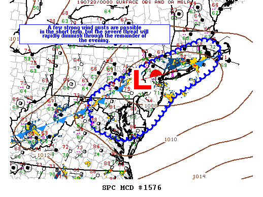
FOR ADDITIONAL INFORMATION SEE MESOSCALE DISCUSSIONS 1573 AND 1574.
..LEITMAN..07/22/19
ATTN...WFO...OKX...BOX...ALY...LWX...PHI...AKQ...CTP...
&&
STATUS REPORT FOR WS 538
SEVERE WEATHER THREAT CONTINUES FOR THE FOLLOWING AREAS
CTC007-011-230040-
CT
. CONNECTICUT COUNTIES INCLUDED ARE
MIDDLESEX NEW LONDON
$$
DEC001-005-230040-
DE
. DELAWARE COUNTIES INCLUDED ARE
KENT SUSSEX
$$
DCC001-230040-
DC
. DISTRICT OF COLUMBIA COUNTIES INCLUDED ARE
DISTRICT OF COLUMBIA
$$
MDC003-009-011-017-019-029-033-035-037-039-041-045-047-230040-
MD
. MARYLAND COUNTIES INCLUDED ARE
ANNE ARUNDEL CALVERT CAROLINE
CHARLES DORCHESTER KENT
PRINCE GEORGES QUEEN ANNE'S ST. MARYS
SOMERSET TALBOT WICOMICO
WORCESTER
$$
NJC001-005-007-009-011-017-021-023-025-029-039-230040-
NJ
. NEW JERSEY COUNTIES INCLUDED ARE
ATLANTIC BURLINGTON CAMDEN
CAPE MAY CUMBERLAND HUDSON
MERCER MIDDLESEX MONMOUTH
OCEAN UNION
$$
NYC005-047-059-061-081-085-103-230040-
NY
. NEW YORK COUNTIES INCLUDED ARE
BRONX KINGS NASSAU
NEW YORK QUEENS RICHMOND
SUFFOLK
$$
RIC001-003-005-009-230040-
RI
. RHODE ISLAND COUNTIES INCLUDED ARE
BRISTOL KENT NEWPORT
WASHINGTON
$$
VAC013-033-057-059-075-085-097-099-101-133-153-159-177-179-193-
510-600-610-630-683-685-230040-
VA
. VIRGINIA COUNTIES INCLUDED ARE
ARLINGTON CAROLINE ESSEX
FAIRFAX GOOCHLAND HANOVER
KING AND QUEEN KING GEORGE KING WILLIAM
NORTHUMBERLAND PRINCE WILLIAM RICHMOND
SPOTSYLVANIA STAFFORD WESTMORELAND
VIRGINIA INDEPENDENT CITIES INCLUDED ARE
ALEXANDRIA FAIRFAX FALLS CHURCH
FREDERICKSBURG MANASSAS MANASSAS PARK
$$
ANZ235-236-237-256-330-335-338-340-345-350-353-355-431-450-451-
452-453-454-455-532-533-534-535-536-537-539-540-541-542-543-
230040-
CW
. ADJACENT COASTAL WATERS INCLUDED ARE
RHODE ISLAND SOUND
NARRAGANSETT BAY
BLOCK ISLAND SOUND
COASTAL WATERS FROM MONTAUK NY TO MARTHAS VINEYARD EXTENDING OUT
TO 20 NM SOUTH OF BLOCK ISLAND
LONG ISLAND SOUND EAST OF NEW HAVEN CT/PORT JEFFERSON NY
LONG ISLAND SOUND WEST OF NEW HAVEN CT/PORT JEFFERSON NY
NEW YORK HARBOR
PECONIC AND GARDINERS BAYS
SOUTH SHORE BAYS FROM JONES INLET THROUGH SHINNECOCK BAY
MORICHES INLET NY TO MONTAUK POINT NY OUT 20 NM
FIRE ISLAND INLET NY TO MORICHES INLET NY OUT 20 NM
SANDY HOOK NJ TO FIRE ISLAND INLET NY OUT 20 NM
DELAWARE BAY WATERS SOUTH OF EAST POINT NJ TO SLAUGHTER BEACH DE
COASTAL WATERS FROM SANDY HOOK TO MANASQUAN INLET NJ OUT 20 NM
COASTAL WATERS FROM MANASQUAN INLET TO LITTLE EGG INLET NJ OUT 20
NM
COASTAL WATERS FROM LITTLE EGG INLET TO GREAT EGG INLET NJ OUT 20
NM
COASTAL WATERS FROM GREAT EGG INLET TO CAPE MAY NJ OUT 20 NM
COASTAL WATERS FROM CAPE MAY NJ TO CAPE HENLOPEN DE OUT 20 NM
COASTAL WATERS FROM CAPE HENLOPEN TO FENWICK ISLAND DE OUT 20 NM
CHESAPEAKE BAY FROM SANDY POINT TO NORTH BEACH MD
CHESAPEAKE BAY FROM NORTH BEACH TO DRUM POINT MD
CHESAPEAKE BAY FROM DRUM POINT MD TO SMITH POINT VA
TIDAL POTOMAC FROM KEY BRIDGE TO INDIAN HEAD MD
TIDAL POTOMAC FROM INDIAN HEAD TO COBB ISLAND MD
TIDAL POTOMAC FROM COBB ISLAND MD TO SMITH POINT VA
CHESTER RIVER TO QUEENSTOWN MD
EASTERN BAY
CHOPTANK RIVER TO CAMBRIDGE MD AND THE LITTLE CHOPTANK RIVER
PATUXENT RIVER TO BROOMES ISLAND MD
TANGIER SOUND AND THE INLAND WATERS SURROUNDING BLOODSWORTH
ISLAND
$$
THE WATCH STATUS MESSAGE IS FOR GUIDANCE PURPOSES ONLY. PLEASE
REFER TO WATCH COUNTY NOTIFICATION STATEMENTS FOR OFFICIAL
INFORMATION ON COUNTIES...INDEPENDENT CITIES AND MARINE ZONES
CLEARED FROM SEVERE THUNDERSTORM AND TORNADO WATCHES.
$$
STATUS REPORT #3 ON WW 538
SEVERE WEATHER THREAT CONTINUES RIGHT OF A LINE FROM 15 ENE SHD
TO 20 WNW DCA TO 20 SW ILG TO 25 E PHL TO 25 NNW TTN TO 25 NW EWR
TO 25 N BDR TO 25 SSW ORH TO 15 S BOS.
..LEITMAN..07/22/19
ATTN...WFO...OKX...BOX...ALY...LWX...PHI...AKQ...CTP...
&&
STATUS REPORT FOR WS 538
SEVERE WEATHER THREAT CONTINUES FOR THE FOLLOWING AREAS
CTC001-007-009-011-013-015-222340-
CT
. CONNECTICUT COUNTIES INCLUDED ARE
FAIRFIELD MIDDLESEX NEW HAVEN
NEW LONDON TOLLAND WINDHAM
$$
DEC001-003-005-222340-
DE
. DELAWARE COUNTIES INCLUDED ARE
KENT NEW CASTLE SUSSEX
$$
DCC001-222340-
DC
. DISTRICT OF COLUMBIA COUNTIES INCLUDED ARE
DISTRICT OF COLUMBIA
$$
MDC003-009-011-017-019-029-033-035-037-039-041-045-047-222340-
MD
. MARYLAND COUNTIES INCLUDED ARE
ANNE ARUNDEL CALVERT CAROLINE
CHARLES DORCHESTER KENT
PRINCE GEORGES QUEEN ANNE'S ST. MARYS
SOMERSET TALBOT WICOMICO
WORCESTER
$$
NJC001-003-005-007-009-011-013-015-017-021-023-025-027-029-031-
033-035-039-222340-
NJ
. NEW JERSEY COUNTIES INCLUDED ARE
ATLANTIC BERGEN BURLINGTON
CAMDEN CAPE MAY CUMBERLAND
ESSEX GLOUCESTER HUDSON
MERCER MIDDLESEX MONMOUTH
MORRIS OCEAN PASSAIC
SALEM SOMERSET UNION
$$
NYC005-047-059-061-081-085-087-103-222340-
NY
. NEW YORK COUNTIES INCLUDED ARE
BRONX KINGS NASSAU
NEW YORK QUEENS RICHMOND
ROCKLAND SUFFOLK
$$
RIC001-003-005-007-009-222340-
RI
. RHODE ISLAND COUNTIES INCLUDED ARE
BRISTOL KENT NEWPORT
PROVIDENCE WASHINGTON
$$
VAC003-013-033-047-057-059-061-065-075-079-085-097-099-101-109-
113-125-133-137-153-159-177-179-193-510-540-600-610-630-683-685-
222340-
VA
. VIRGINIA COUNTIES INCLUDED ARE
ALBEMARLE ARLINGTON CAROLINE
CULPEPER ESSEX FAIRFAX
FAUQUIER FLUVANNA GOOCHLAND
GREENE HANOVER KING AND QUEEN
KING GEORGE KING WILLIAM LOUISA
MADISON NELSON NORTHUMBERLAND
ORANGE PRINCE WILLIAM RICHMOND
SPOTSYLVANIA STAFFORD WESTMORELAND
VIRGINIA INDEPENDENT CITIES INCLUDED ARE
ALEXANDRIA CHARLOTTESVILLE FAIRFAX
FALLS CHURCH FREDERICKSBURG MANASSAS
MANASSAS PARK
$$
ANZ235-236-237-256-330-335-338-340-345-350-353-355-430-431-450-
451-452-453-454-455-532-533-534-535-536-537-539-540-541-542-543-
222340-
CW
. ADJACENT COASTAL WATERS INCLUDED ARE
RHODE ISLAND SOUND
NARRAGANSETT BAY
BLOCK ISLAND SOUND
COASTAL WATERS FROM MONTAUK NY TO MARTHAS VINEYARD EXTENDING OUT
TO 20 NM SOUTH OF BLOCK ISLAND
LONG ISLAND SOUND EAST OF NEW HAVEN CT/PORT JEFFERSON NY
LONG ISLAND SOUND WEST OF NEW HAVEN CT/PORT JEFFERSON NY
NEW YORK HARBOR
PECONIC AND GARDINERS BAYS
SOUTH SHORE BAYS FROM JONES INLET THROUGH SHINNECOCK BAY
MORICHES INLET NY TO MONTAUK POINT NY OUT 20 NM
FIRE ISLAND INLET NY TO MORICHES INLET NY OUT 20 NM
SANDY HOOK NJ TO FIRE ISLAND INLET NY OUT 20 NM
DELAWARE BAY WATERS NORTH OF EAST POINT NJ TO SLAUGHTER BEACH DE
DELAWARE BAY WATERS SOUTH OF EAST POINT NJ TO SLAUGHTER BEACH DE
COASTAL WATERS FROM SANDY HOOK TO MANASQUAN INLET NJ OUT 20 NM
COASTAL WATERS FROM MANASQUAN INLET TO LITTLE EGG INLET NJ OUT 20
NM
COASTAL WATERS FROM LITTLE EGG INLET TO GREAT EGG INLET NJ OUT 20
NM
COASTAL WATERS FROM GREAT EGG INLET TO CAPE MAY NJ OUT 20 NM
COASTAL WATERS FROM CAPE MAY NJ TO CAPE HENLOPEN DE OUT 20 NM
COASTAL WATERS FROM CAPE HENLOPEN TO FENWICK ISLAND DE OUT 20 NM
CHESAPEAKE BAY FROM SANDY POINT TO NORTH BEACH MD
CHESAPEAKE BAY FROM NORTH BEACH TO DRUM POINT MD
CHESAPEAKE BAY FROM DRUM POINT MD TO SMITH POINT VA
TIDAL POTOMAC FROM KEY BRIDGE TO INDIAN HEAD MD
TIDAL POTOMAC FROM INDIAN HEAD TO COBB ISLAND MD
TIDAL POTOMAC FROM COBB ISLAND MD TO SMITH POINT VA
CHESTER RIVER TO QUEENSTOWN MD
EASTERN BAY
CHOPTANK RIVER TO CAMBRIDGE MD AND THE LITTLE CHOPTANK RIVER
PATUXENT RIVER TO BROOMES ISLAND MD
TANGIER SOUND AND THE INLAND WATERS SURROUNDING BLOODSWORTH
ISLAND
$$
THE WATCH STATUS MESSAGE IS FOR GUIDANCE PURPOSES ONLY. PLEASE
REFER TO WATCH COUNTY NOTIFICATION STATEMENTS FOR OFFICIAL
INFORMATION ON COUNTIES...INDEPENDENT CITIES AND MARINE ZONES
CLEARED FROM SEVERE THUNDERSTORM AND TORNADO WATCHES.
$$
STATUS REPORT #2 ON WW 538
SEVERE WEATHER THREAT CONTINUES RIGHT OF A LINE FROM 10 ENE SHD
TO 35 NNE CHO TO 35 SSE MRB TO 25 NW DCA TO 15 NNW BWI TO 25 NE
BWI TO 30 WNW ILG TO 40 SW ABE TO 10 ESE AVP.
..BENTLEY..07/22/19
ATTN...WFO...OKX...BOX...ALY...LWX...PHI...AKQ...CTP...
&&
STATUS REPORT FOR WS 538
SEVERE WEATHER THREAT CONTINUES FOR THE FOLLOWING AREAS
CTC001-003-005-007-009-011-013-015-222240-
CT
. CONNECTICUT COUNTIES INCLUDED ARE
FAIRFIELD HARTFORD LITCHFIELD
MIDDLESEX NEW HAVEN NEW LONDON
TOLLAND WINDHAM
$$
DEC001-003-005-222240-
DE
. DELAWARE COUNTIES INCLUDED ARE
KENT NEW CASTLE SUSSEX
$$
DCC001-222240-
DC
. DISTRICT OF COLUMBIA COUNTIES INCLUDED ARE
DISTRICT OF COLUMBIA
$$
MDC003-009-011-015-017-019-025-027-029-031-033-035-037-039-041-
045-047-510-222240-
MD
. MARYLAND COUNTIES INCLUDED ARE
ANNE ARUNDEL CALVERT CAROLINE
CECIL CHARLES DORCHESTER
HARFORD HOWARD KENT
MONTGOMERY PRINCE GEORGES QUEEN ANNE'S
ST. MARYS SOMERSET TALBOT
WICOMICO WORCESTER
MARYLAND INDEPENDENT CITIES INCLUDED ARE
BALTIMORE CITY
$$
NJC001-003-005-007-009-011-013-015-017-019-021-023-025-027-029-
031-033-035-037-039-041-222240-
NJ
. NEW JERSEY COUNTIES INCLUDED ARE
ATLANTIC BERGEN BURLINGTON
CAMDEN CAPE MAY CUMBERLAND
ESSEX GLOUCESTER HUDSON
HUNTERDON MERCER MIDDLESEX
MONMOUTH MORRIS OCEAN
PASSAIC SALEM SOMERSET
SUSSEX UNION WARREN
$$
NYC005-027-047-059-061-071-079-081-085-087-103-119-222240-
NY
. NEW YORK COUNTIES INCLUDED ARE
BRONX DUTCHESS KINGS
NASSAU NEW YORK ORANGE
PUTNAM QUEENS RICHMOND
ROCKLAND SUFFOLK WESTCHESTER
$$
PAC011-017-029-045-077-091-095-101-222240-
PA
. PENNSYLVANIA COUNTIES INCLUDED ARE
BERKS BUCKS CHESTER
DELAWARE LEHIGH MONTGOMERY
NORTHAMPTON PHILADELPHIA
$$
RIC001-003-005-007-009-222240-
RI
. RHODE ISLAND COUNTIES INCLUDED ARE
BRISTOL KENT NEWPORT
PROVIDENCE WASHINGTON
$$
VAC003-013-033-047-057-059-061-065-075-079-085-097-099-101-107-
109-113-125-133-137-153-157-159-177-179-193-510-540-600-610-630-
683-685-222240-
VA
. VIRGINIA COUNTIES INCLUDED ARE
ALBEMARLE ARLINGTON CAROLINE
CULPEPER ESSEX FAIRFAX
FAUQUIER FLUVANNA GOOCHLAND
GREENE HANOVER KING AND QUEEN
KING GEORGE KING WILLIAM LOUDOUN
LOUISA MADISON NELSON
NORTHUMBERLAND ORANGE PRINCE WILLIAM
RAPPAHANNOCK RICHMOND SPOTSYLVANIA
STAFFORD WESTMORELAND
VIRGINIA INDEPENDENT CITIES INCLUDED ARE
ALEXANDRIA CHARLOTTESVILLE FAIRFAX
FALLS CHURCH FREDERICKSBURG MANASSAS
MANASSAS PARK
$$
ANZ235-236-237-256-330-335-338-340-345-350-353-355-430-431-450-
451-452-453-454-455-530-532-533-534-535-536-537-538-539-540-541-
542-543-222240-
CW
. ADJACENT COASTAL WATERS INCLUDED ARE
RHODE ISLAND SOUND
NARRAGANSETT BAY
BLOCK ISLAND SOUND
COASTAL WATERS FROM MONTAUK NY TO MARTHAS VINEYARD EXTENDING OUT
TO 20 NM SOUTH OF BLOCK ISLAND
LONG ISLAND SOUND EAST OF NEW HAVEN CT/PORT JEFFERSON NY
LONG ISLAND SOUND WEST OF NEW HAVEN CT/PORT JEFFERSON NY
NEW YORK HARBOR
PECONIC AND GARDINERS BAYS
SOUTH SHORE BAYS FROM JONES INLET THROUGH SHINNECOCK BAY
MORICHES INLET NY TO MONTAUK POINT NY OUT 20 NM
FIRE ISLAND INLET NY TO MORICHES INLET NY OUT 20 NM
SANDY HOOK NJ TO FIRE ISLAND INLET NY OUT 20 NM
DELAWARE BAY WATERS NORTH OF EAST POINT NJ TO SLAUGHTER BEACH DE
DELAWARE BAY WATERS SOUTH OF EAST POINT NJ TO SLAUGHTER BEACH DE
COASTAL WATERS FROM SANDY HOOK TO MANASQUAN INLET NJ OUT 20 NM
COASTAL WATERS FROM MANASQUAN INLET TO LITTLE EGG INLET NJ OUT 20
NM
COASTAL WATERS FROM LITTLE EGG INLET TO GREAT EGG INLET NJ OUT 20
NM
COASTAL WATERS FROM GREAT EGG INLET TO CAPE MAY NJ OUT 20 NM
COASTAL WATERS FROM CAPE MAY NJ TO CAPE HENLOPEN DE OUT 20 NM
COASTAL WATERS FROM CAPE HENLOPEN TO FENWICK ISLAND DE OUT 20 NM
CHESAPEAKE BAY NORTH OF POOLES ISLAND MD
CHESAPEAKE BAY FROM SANDY POINT TO NORTH BEACH MD
CHESAPEAKE BAY FROM NORTH BEACH TO DRUM POINT MD
CHESAPEAKE BAY FROM DRUM POINT MD TO SMITH POINT VA
TIDAL POTOMAC FROM KEY BRIDGE TO INDIAN HEAD MD
TIDAL POTOMAC FROM INDIAN HEAD TO COBB ISLAND MD
TIDAL POTOMAC FROM COBB ISLAND MD TO SMITH POINT VA
PATAPSCO RIVER INCLUDING BALTIMORE HARBOR
CHESTER RIVER TO QUEENSTOWN MD
EASTERN BAY
CHOPTANK RIVER TO CAMBRIDGE MD AND THE LITTLE CHOPTANK RIVER
PATUXENT RIVER TO BROOMES ISLAND MD
TANGIER SOUND AND THE INLAND WATERS SURROUNDING BLOODSWORTH
ISLAND
$$
THE WATCH STATUS MESSAGE IS FOR GUIDANCE PURPOSES ONLY. PLEASE
REFER TO WATCH COUNTY NOTIFICATION STATEMENTS FOR OFFICIAL
INFORMATION ON COUNTIES...INDEPENDENT CITIES AND MARINE ZONES
CLEARED FROM SEVERE THUNDERSTORM AND TORNADO WATCHES.
$$
STATUS REPORT #1 ON WW 538
THE SEVERE WEATHER THREAT CONTINUES ACROSS THE ENTIRE WATCH AREA.
..GOSS..07/22/19
ATTN...WFO...OKX...BOX...ALY...LWX...PHI...AKQ...CTP...
&&
STATUS REPORT FOR WS 538
SEVERE WEATHER THREAT CONTINUES FOR THE FOLLOWING AREAS
CTC001-003-005-007-009-011-013-015-222040-
CT
. CONNECTICUT COUNTIES INCLUDED ARE
FAIRFIELD HARTFORD LITCHFIELD
MIDDLESEX NEW HAVEN NEW LONDON
TOLLAND WINDHAM
$$
DEC001-003-005-222040-
DE
. DELAWARE COUNTIES INCLUDED ARE
KENT NEW CASTLE SUSSEX
$$
DCC001-222040-
DC
. DISTRICT OF COLUMBIA COUNTIES INCLUDED ARE
DISTRICT OF COLUMBIA
$$
MDC003-005-009-011-013-015-017-019-021-025-027-029-031-033-035-
037-039-041-045-047-510-222040-
MD
. MARYLAND COUNTIES INCLUDED ARE
ANNE ARUNDEL BALTIMORE CALVERT
CAROLINE CARROLL CECIL
CHARLES DORCHESTER FREDERICK
HARFORD HOWARD KENT
MONTGOMERY PRINCE GEORGES QUEEN ANNE'S
ST. MARYS SOMERSET TALBOT
WICOMICO WORCESTER
MARYLAND INDEPENDENT CITIES INCLUDED ARE
BALTIMORE CITY
$$
NJC001-003-005-007-009-011-013-015-017-019-021-023-025-027-029-
031-033-035-037-039-041-222040-
NJ
. NEW JERSEY COUNTIES INCLUDED ARE
ATLANTIC BERGEN BURLINGTON
CAMDEN CAPE MAY CUMBERLAND
ESSEX GLOUCESTER HUDSON
HUNTERDON MERCER MIDDLESEX
MONMOUTH MORRIS OCEAN
PASSAIC SALEM SOMERSET
SUSSEX UNION WARREN
$$
NYC005-027-047-059-061-071-079-081-085-087-103-119-222040-
NY
. NEW YORK COUNTIES INCLUDED ARE
BRONX DUTCHESS KINGS
NASSAU NEW YORK ORANGE
PUTNAM QUEENS RICHMOND
ROCKLAND SUFFOLK WESTCHESTER
$$
PAC001-011-017-025-029-043-045-071-075-077-089-091-095-101-107-
133-222040-
PA
. PENNSYLVANIA COUNTIES INCLUDED ARE
ADAMS BERKS BUCKS
CARBON CHESTER DAUPHIN
DELAWARE LANCASTER LEBANON
LEHIGH MONROE MONTGOMERY
NORTHAMPTON PHILADELPHIA SCHUYLKILL
YORK
$$
RIC001-003-005-007-009-222040-
RI
. RHODE ISLAND COUNTIES INCLUDED ARE
BRISTOL KENT NEWPORT
PROVIDENCE WASHINGTON
$$
VAC003-013-033-047-057-059-061-065-075-079-085-097-099-101-107-
109-113-125-133-137-153-157-159-177-179-193-510-540-600-610-630-
683-685-222040-
VA
. VIRGINIA COUNTIES INCLUDED ARE
ALBEMARLE ARLINGTON CAROLINE
CULPEPER ESSEX FAIRFAX
FAUQUIER FLUVANNA GOOCHLAND
GREENE HANOVER KING AND QUEEN
KING GEORGE KING WILLIAM LOUDOUN
LOUISA MADISON NELSON
NORTHUMBERLAND ORANGE PRINCE WILLIAM
RAPPAHANNOCK RICHMOND SPOTSYLVANIA
STAFFORD WESTMORELAND
VIRGINIA INDEPENDENT CITIES INCLUDED ARE
ALEXANDRIA CHARLOTTESVILLE FAIRFAX
FALLS CHURCH FREDERICKSBURG MANASSAS
MANASSAS PARK
$$
ANZ235-236-237-256-330-335-338-340-345-350-353-355-430-431-450-
451-452-453-454-455-530-531-532-533-534-535-536-537-538-539-540-
541-542-543-222040-
CW
. ADJACENT COASTAL WATERS INCLUDED ARE
RHODE ISLAND SOUND
NARRAGANSETT BAY
BLOCK ISLAND SOUND
COASTAL WATERS FROM MONTAUK NY TO MARTHAS VINEYARD EXTENDING OUT
TO 20 NM SOUTH OF BLOCK ISLAND
LONG ISLAND SOUND EAST OF NEW HAVEN CT/PORT JEFFERSON NY
LONG ISLAND SOUND WEST OF NEW HAVEN CT/PORT JEFFERSON NY
NEW YORK HARBOR
PECONIC AND GARDINERS BAYS
SOUTH SHORE BAYS FROM JONES INLET THROUGH SHINNECOCK BAY
MORICHES INLET NY TO MONTAUK POINT NY OUT 20 NM
FIRE ISLAND INLET NY TO MORICHES INLET NY OUT 20 NM
SANDY HOOK NJ TO FIRE ISLAND INLET NY OUT 20 NM
DELAWARE BAY WATERS NORTH OF EAST POINT NJ TO SLAUGHTER BEACH DE
DELAWARE BAY WATERS SOUTH OF EAST POINT NJ TO SLAUGHTER BEACH DE
COASTAL WATERS FROM SANDY HOOK TO MANASQUAN INLET NJ OUT 20 NM
COASTAL WATERS FROM MANASQUAN INLET TO LITTLE EGG INLET NJ OUT 20
NM
COASTAL WATERS FROM LITTLE EGG INLET TO GREAT EGG INLET NJ OUT 20
NM
COASTAL WATERS FROM GREAT EGG INLET TO CAPE MAY NJ OUT 20 NM
COASTAL WATERS FROM CAPE MAY NJ TO CAPE HENLOPEN DE OUT 20 NM
COASTAL WATERS FROM CAPE HENLOPEN TO FENWICK ISLAND DE OUT 20 NM
CHESAPEAKE BAY NORTH OF POOLES ISLAND MD
CHESAPEAKE BAY FROM POOLES ISLAND TO SANDY POINT MD
CHESAPEAKE BAY FROM SANDY POINT TO NORTH BEACH MD
CHESAPEAKE BAY FROM NORTH BEACH TO DRUM POINT MD
CHESAPEAKE BAY FROM DRUM POINT MD TO SMITH POINT VA
TIDAL POTOMAC FROM KEY BRIDGE TO INDIAN HEAD MD
TIDAL POTOMAC FROM INDIAN HEAD TO COBB ISLAND MD
TIDAL POTOMAC FROM COBB ISLAND MD TO SMITH POINT VA
PATAPSCO RIVER INCLUDING BALTIMORE HARBOR
CHESTER RIVER TO QUEENSTOWN MD
EASTERN BAY
CHOPTANK RIVER TO CAMBRIDGE MD AND THE LITTLE CHOPTANK RIVER
PATUXENT RIVER TO BROOMES ISLAND MD
TANGIER SOUND AND THE INLAND WATERS SURROUNDING BLOODSWORTH
ISLAND
$$
THE WATCH STATUS MESSAGE IS FOR GUIDANCE PURPOSES ONLY. PLEASE
REFER TO WATCH COUNTY NOTIFICATION STATEMENTS FOR OFFICIAL
INFORMATION ON COUNTIES...INDEPENDENT CITIES AND MARINE ZONES
CLEARED FROM SEVERE THUNDERSTORM AND TORNADO WATCHES.
$$
Note:
Click for Complete Product Text.
Tornadoes
Probability of 2 or more tornadoes
|
Low (20%)
|
Probability of 1 or more strong (EF2-EF5) tornadoes
|
Low (5%)
|
Wind
Probability of 10 or more severe wind events
|
Mod (60%)
|
Probability of 1 or more wind events > 65 knots
|
Low (10%)
|
Hail
Probability of 10 or more severe hail events
|
Low (<5%)
|
Probability of 1 or more hailstones > 2 inches
|
Low (<5%)
|
Combined Severe Hail/Wind
Probability of 6 or more combined severe hail/wind events
|
High (80%)
|
For each watch, probabilities for particular events inside the watch
(listed above in each table) are determined by the issuing forecaster.
The "Low" category contains probability values ranging from less than 2%
to 20% (EF2-EF5 tornadoes), less than 5% to 20% (all other probabilities),
"Moderate" from 30% to 60%, and "High" from 70% to greater than 95%.
High values are bolded and lighter in color to provide awareness of
an increased threat for a particular event.


 @NWSSPC