 Note:
The expiration time in the watch graphic is amended if the watch is
replaced, cancelled or extended.
Note:
Note:
The expiration time in the watch graphic is amended if the watch is
replaced, cancelled or extended.
Note: Click for
Watch Status Reports.
SEL7
URGENT - IMMEDIATE BROADCAST REQUESTED
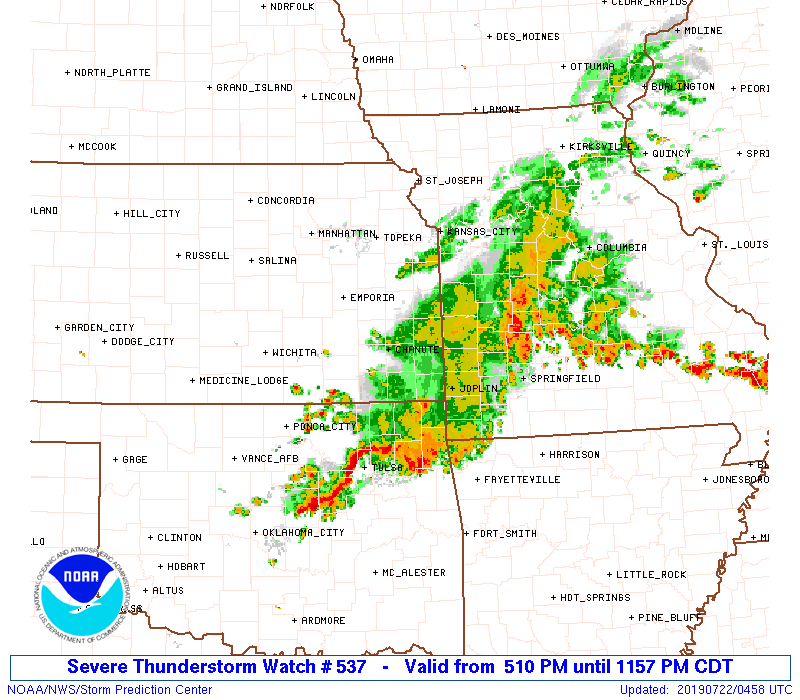
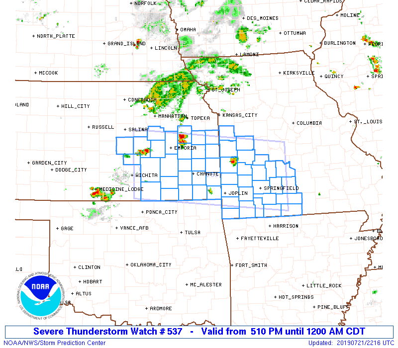
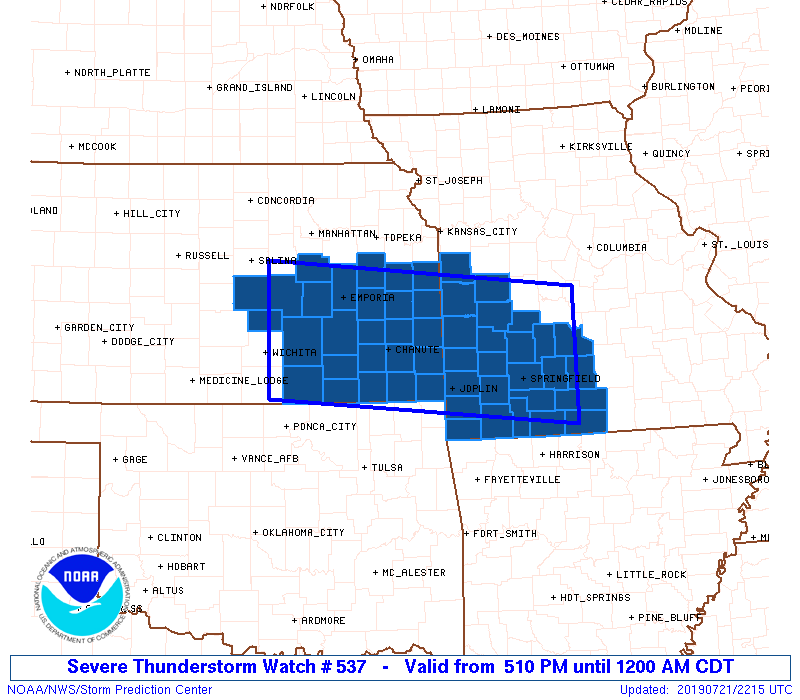
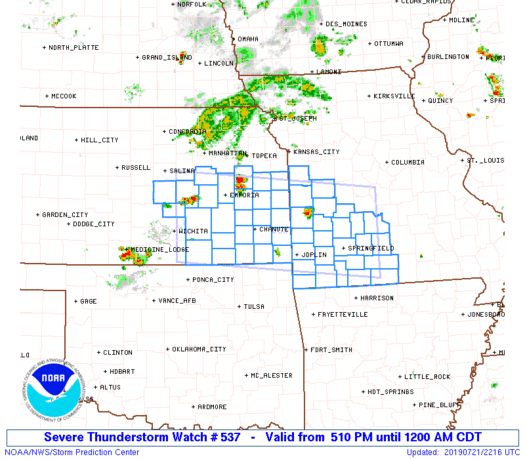
Severe Thunderstorm Watch Number 537
NWS Storm Prediction Center Norman OK
510 PM CDT Sun Jul 21 2019
The NWS Storm Prediction Center has issued a
* Severe Thunderstorm Watch for portions of
East central and southeast Kansas
West central and southwest Missouri
* Effective this Sunday afternoon from 510 PM until Midnight CDT.
* Primary threats include...
Scattered damaging wind gusts to 70 mph possible
Isolated large hail events to 1 inch in diameter possible
A tornado or two possible
SUMMARY...Thunderstorms are beginning to develop from southwest
Missouri into eastern Kansas along a slow-moving outflow boundary.
Strong instability is present south of the boundary, which will
support some expansion and intensification of the storms through
this evening. Transient supercell structures may occur in the first
couple of hours of the watch, when an isolated/brief tornado cannot
be ruled out with storms along the boundary. Otherwise, storms will
evolve into multicell clusters with the primary threats of damaging
outflow winds and marginally severe hail.
The severe thunderstorm watch area is approximately along and 60
statute miles north and south of a line from 70 miles west southwest
of Emporia KS to 50 miles east northeast of Springfield MO. For a
complete depiction of the watch see the associated watch outline
update (WOUS64 KWNS WOU7).
PRECAUTIONARY/PREPAREDNESS ACTIONS...
REMEMBER...A Severe Thunderstorm Watch means conditions are
favorable for severe thunderstorms in and close to the watch area.
Persons in these areas should be on the lookout for threatening
weather conditions and listen for later statements and possible
warnings. Severe thunderstorms can and occasionally do produce
tornadoes.
&&
AVIATION...A few severe thunderstorms with hail surface and aloft to
1 inch. Extreme turbulence and surface wind gusts to 60 knots. A few
cumulonimbi with maximum tops to 600. Mean storm motion vector
31020.
...Thompson

   SEL7

   URGENT - IMMEDIATE BROADCAST REQUESTED
   Severe Thunderstorm Watch Number 537
   NWS Storm Prediction Center Norman OK
   510 PM CDT Sun Jul 21 2019

   The NWS Storm Prediction Center has issued a

   * Severe Thunderstorm Watch for portions of
     East central and southeast Kansas
     West central and southwest Missouri

   * Effective this Sunday afternoon from 510 PM until Midnight CDT.

   * Primary threats include...
     Scattered damaging wind gusts to 70 mph possible
     Isolated large hail events to 1 inch in diameter possible
     A tornado or two possible

   SUMMARY...Thunderstorms are beginning to develop from southwest
   Missouri into eastern Kansas along a slow-moving outflow boundary.
   Strong instability is present south of the boundary, which will
   support some expansion and intensification of the storms through
   this evening.  Transient supercell structures may occur in the first
   couple of hours of the watch, when an isolated/brief tornado cannot
   be ruled out with storms along the boundary.  Otherwise, storms will
   evolve into multicell clusters with the primary threats of damaging
   outflow winds and marginally severe hail.

   The severe thunderstorm watch area is approximately along and 60
   statute miles north and south of a line from 70 miles west southwest
   of Emporia KS to 50 miles east northeast of Springfield MO. For a
   complete depiction of the watch see the associated watch outline
   update (WOUS64 KWNS WOU7).

   PRECAUTIONARY/PREPAREDNESS ACTIONS...

   REMEMBER...A Severe Thunderstorm Watch means conditions are
   favorable for severe thunderstorms in and close to the watch area.
   Persons in these areas should be on the lookout for threatening
   weather conditions and listen for later statements and possible
   warnings. Severe thunderstorms can and occasionally do produce
   tornadoes.

   &&

   AVIATION...A few severe thunderstorms with hail surface and aloft to
   1 inch. Extreme turbulence and surface wind gusts to 60 knots. A few
   cumulonimbi with maximum tops to 600. Mean storm motion vector
   31020.

   ...Thompson
 Note:
The Aviation Watch (SAW) product is an approximation to the watch area.
The actual watch is depicted by the shaded areas.
Note:
The Aviation Watch (SAW) product is an approximation to the watch area.
The actual watch is depicted by the shaded areas.
   SAW7
   WW 537 SEVERE TSTM KS MO 212210Z - 220500Z
   AXIS..60 STATUTE MILES NORTH AND SOUTH OF LINE..
   70WSW EMP/EMPORIA KS/ - 50ENE SGF/SPRINGFIELD MO/
   ..AVIATION COORDS.. 50NM N/S /15NE ICT - 39ENE SGF/
   HAIL SURFACE AND ALOFT..1 INCH. WIND GUSTS..60 KNOTS.
   MAX TOPS TO 600. MEAN STORM MOTION VECTOR 31020.

   LAT...LON 38799737 38369254 36639254 37069737

   THIS IS AN APPROXIMATION TO THE WATCH AREA.  FOR A
   COMPLETE DEPICTION OF THE WATCH SEE WOUS64 KWNS
   FOR WOU7.
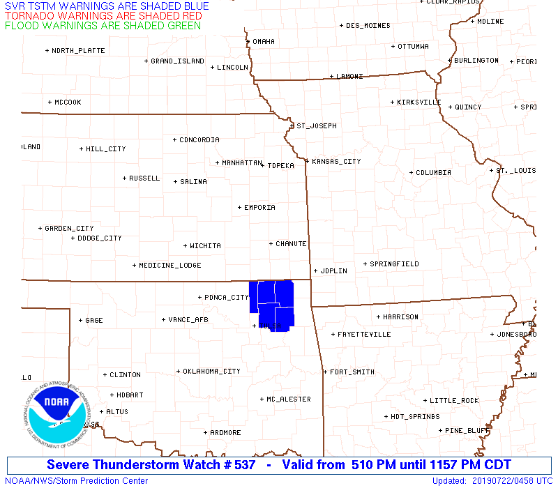
Watch 537 Status Report Messages:
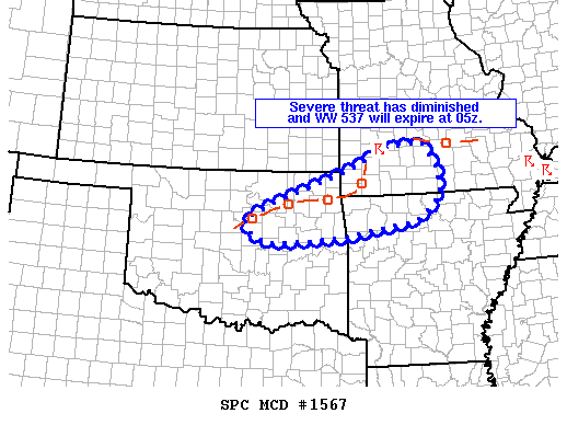
STATUS REPORT #5 ON WW 537

VALID 220425Z - 220540Z

SEVERE WEATHER THREAT CONTINUES RIGHT OF A LINE FROM 5 NNW GMJ TO
15 WNW UMN TO 15 NNW SGF TO 10 S TBN.

..LEITMAN..07/22/19

ATTN...WFO...ICT...TOP...SGF...EAX...

&&

STATUS REPORT FOR WS 537

SEVERE WEATHER THREAT CONTINUES FOR THE FOLLOWING AREAS

MOC009-043-067-077-109-119-153-209-213-225-229-220540-

MO
.    MISSOURI COUNTIES INCLUDED ARE

BARRY		     CHRISTIAN		 DOUGLAS
GREENE		     LAWRENCE		 MCDONALD
OZARK		     STONE		 TANEY
WEBSTER 	     WRIGHT
$$


THE WATCH STATUS MESSAGE IS FOR GUIDANCE PURPOSES ONLY.  PLEASE
REFER TO WATCH COUNTY NOTIFICATION STATEMENTS FOR OFFICIAL
INFORMATION ON COUNTIES...INDEPENDENT CITIES AND MARINE ZONES
CLEARED FROM SEVERE THUNDERSTORM AND TORNADO WATCHES.
$$

STATUS REPORT #4 ON WW 537

VALID 220250Z - 220340Z

SEVERE WEATHER THREAT CONTINUES RIGHT OF A LINE FROM 25 NE PNC TO
30 SSW CNU TO 30 E CNU TO 50 NNW SGF TO 15 NW TBN.

..LEITMAN..07/22/19

ATTN...WFO...ICT...TOP...SGF...EAX...

&&

STATUS REPORT FOR WS 537

SEVERE WEATHER THREAT CONTINUES FOR THE FOLLOWING AREAS

KSC019-021-037-099-125-220340-

KS
.    KANSAS COUNTIES INCLUDED ARE

CHAUTAUQUA	     CHEROKEE		 CRAWFORD
LABETTE 	     MONTGOMERY
$$


MOC009-011-039-043-057-059-067-077-097-105-109-119-145-153-167-
209-213-225-229-220340-

MO
.    MISSOURI COUNTIES INCLUDED ARE

BARRY		     BARTON		 CEDAR
CHRISTIAN	     DADE		 DALLAS
DOUGLAS 	     GREENE		 JASPER
LACLEDE 	     LAWRENCE		 MCDONALD
NEWTON		     OZARK		 POLK
STONE		     TANEY		 WEBSTER
WRIGHT
$$


THE WATCH STATUS MESSAGE IS FOR GUIDANCE PURPOSES ONLY.  PLEASE
REFER TO WATCH COUNTY NOTIFICATION STATEMENTS FOR OFFICIAL
INFORMATION ON COUNTIES...INDEPENDENT CITIES AND MARINE ZONES
CLEARED FROM SEVERE THUNDERSTORM AND TORNADO WATCHES.
$$

STATUS REPORT #3 ON WW 537

VALID 220125Z - 220240Z

SEVERE WEATHER THREAT CONTINUES RIGHT OF A LINE FROM 15 NE HUT TO
55 N JLN TO 40 WNW TBN.

FOR ADDITIONAL INFORMATION SEE MESOSCALE DISCUSSION 1565.

..LEITMAN..07/22/19

ATTN...WFO...ICT...TOP...SGF...EAX...

&&

STATUS REPORT FOR WS 537

SEVERE WEATHER THREAT CONTINUES FOR THE FOLLOWING AREAS

KSC001-011-015-019-021-035-037-049-073-099-125-133-173-191-205-
207-220240-

KS
.    KANSAS COUNTIES INCLUDED ARE

ALLEN		     BOURBON		 BUTLER
CHAUTAUQUA	     CHEROKEE		 COWLEY
CRAWFORD	     ELK		 GREENWOOD
LABETTE 	     MONTGOMERY 	 NEOSHO
SEDGWICK	     SUMNER		 WILSON
WOODSON
$$


MOC009-011-039-043-057-059-067-077-085-097-105-109-119-145-153-
167-185-209-213-217-225-229-220240-

MO
.    MISSOURI COUNTIES INCLUDED ARE

BARRY		     BARTON		 CEDAR
CHRISTIAN	     DADE		 DALLAS
DOUGLAS 	     GREENE		 HICKORY
JASPER		     LACLEDE		 LAWRENCE
MCDONALD	     NEWTON		 OZARK
POLK		     ST. CLAIR		 STONE
TANEY		     VERNON		 WEBSTER
WRIGHT
$$


THE WATCH STATUS MESSAGE IS FOR GUIDANCE PURPOSES ONLY.  PLEASE
REFER TO WATCH COUNTY NOTIFICATION STATEMENTS FOR OFFICIAL
INFORMATION ON COUNTIES...INDEPENDENT CITIES AND MARINE ZONES
CLEARED FROM SEVERE THUNDERSTORM AND TORNADO WATCHES.
$$

STATUS REPORT #2 ON WW 537

VALID 220045Z - 220140Z

THE SEVERE WEATHER THREAT CONTINUES ACROSS THE ENTIRE WATCH AREA.

..LEITMAN..07/22/19

ATTN...WFO...ICT...TOP...SGF...EAX...

&&

STATUS REPORT FOR WS 537

SEVERE WEATHER THREAT CONTINUES FOR THE FOLLOWING AREAS

KSC001-003-011-015-017-019-021-031-035-037-049-059-073-079-099-
107-111-113-115-121-125-127-133-139-205-207-220140-

KS
.    KANSAS COUNTIES INCLUDED ARE

ALLEN		     ANDERSON		 BOURBON
BUTLER		     CHASE		 CHAUTAUQUA
CHEROKEE	     COFFEY		 COWLEY
CRAWFORD	     ELK		 FRANKLIN
GREENWOOD	     HARVEY		 LABETTE
LINN		     LYON		 MCPHERSON
MARION		     MIAMI		 MONTGOMERY
MORRIS		     NEOSHO		 OSAGE
WILSON		     WOODSON
$$


MOC009-011-013-037-039-043-057-059-067-077-083-085-097-105-109-
119-145-153-167-185-209-213-217-225-229-220140-

MO
.    MISSOURI COUNTIES INCLUDED ARE

BARRY		     BARTON		 BATES
CASS		     CEDAR		 CHRISTIAN
DADE		     DALLAS		 DOUGLAS
GREENE		     HENRY		 HICKORY
JASPER		     LACLEDE		 LAWRENCE
MCDONALD	     NEWTON		 OZARK
POLK		     ST. CLAIR		 STONE
TANEY		     VERNON		 WEBSTER
WRIGHT
$$


THE WATCH STATUS MESSAGE IS FOR GUIDANCE PURPOSES ONLY.  PLEASE
REFER TO WATCH COUNTY NOTIFICATION STATEMENTS FOR OFFICIAL
INFORMATION ON COUNTIES...INDEPENDENT CITIES AND MARINE ZONES
CLEARED FROM SEVERE THUNDERSTORM AND TORNADO WATCHES.
$$

STATUS REPORT #1 ON WW 537

VALID 212320Z - 220040Z

THE SEVERE WEATHER THREAT CONTINUES ACROSS THE ENTIRE WATCH AREA.

..LEITMAN..07/21/19

ATTN...WFO...ICT...TOP...SGF...EAX...

&&

STATUS REPORT FOR WS 537

SEVERE WEATHER THREAT CONTINUES FOR THE FOLLOWING AREAS

KSC001-003-011-015-017-019-021-031-035-037-049-059-073-079-099-
107-111-113-115-121-125-127-133-139-205-207-220040-

KS
.    KANSAS COUNTIES INCLUDED ARE

ALLEN		     ANDERSON		 BOURBON
BUTLER		     CHASE		 CHAUTAUQUA
CHEROKEE	     COFFEY		 COWLEY
CRAWFORD	     ELK		 FRANKLIN
GREENWOOD	     HARVEY		 LABETTE
LINN		     LYON		 MCPHERSON
MARION		     MIAMI		 MONTGOMERY
MORRIS		     NEOSHO		 OSAGE
WILSON		     WOODSON
$$


MOC009-011-013-037-039-043-057-059-067-077-083-085-097-105-109-
119-145-153-167-185-209-213-217-225-229-220040-

MO
.    MISSOURI COUNTIES INCLUDED ARE

BARRY		     BARTON		 BATES
CASS		     CEDAR		 CHRISTIAN
DADE		     DALLAS		 DOUGLAS
GREENE		     HENRY		 HICKORY
JASPER		     LACLEDE		 LAWRENCE
MCDONALD	     NEWTON		 OZARK
POLK		     ST. CLAIR		 STONE
TANEY		     VERNON		 WEBSTER
WRIGHT
$$


THE WATCH STATUS MESSAGE IS FOR GUIDANCE PURPOSES ONLY.  PLEASE
REFER TO WATCH COUNTY NOTIFICATION STATEMENTS FOR OFFICIAL
INFORMATION ON COUNTIES...INDEPENDENT CITIES AND MARINE ZONES
CLEARED FROM SEVERE THUNDERSTORM AND TORNADO WATCHES.
$$
Note:
Click for Complete Product Text.
Tornadoes
Probability of 2 or more tornadoes
|
Low (20%)
|
Probability of 1 or more strong (EF2-EF5) tornadoes
|
Low (<2%)
|
Wind
Probability of 10 or more severe wind events
|
Mod (40%)
|
Probability of 1 or more wind events > 65 knots
|
Low (20%)
|
Hail
Probability of 10 or more severe hail events
|
Low (20%)
|
Probability of 1 or more hailstones > 2 inches
|
Low (10%)
|
Combined Severe Hail/Wind
Probability of 6 or more combined severe hail/wind events
|
Mod (60%)
|
For each watch, probabilities for particular events inside the watch
(listed above in each table) are determined by the issuing forecaster.
The "Low" category contains probability values ranging from less than 2%
to 20% (EF2-EF5 tornadoes), less than 5% to 20% (all other probabilities),
"Moderate" from 30% to 60%, and "High" from 70% to greater than 95%.
High values are bolded and lighter in color to provide awareness of
an increased threat for a particular event.


 @NWSSPC