|
| Mesoscale Discussion 1567 |
|
< Previous MD Next MD >
|
|
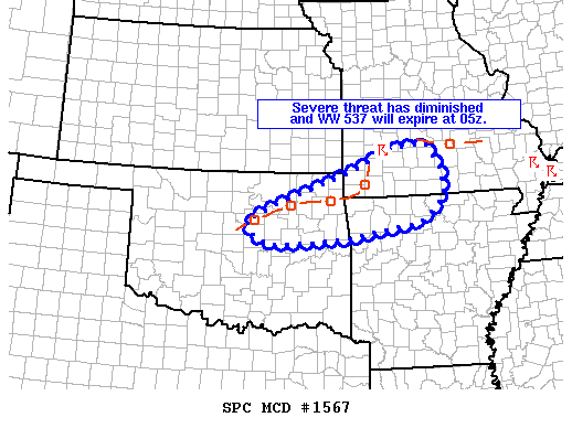
   Mesoscale Discussion 1567
   NWS Storm Prediction Center Norman OK
   1140 PM CDT Sun Jul 21 2019

   Areas affected...northeast OK into southwest MO and northwest AR

   Concerning...Severe Thunderstorm Watch 537...

   Valid 220440Z - 220545Z

   The severe weather threat for Severe Thunderstorm Watch 537
   continues.

   SUMMARY...Overall weakening trend is expected to continue with
   storms shifting southeast across the MCD area late this evening. A
   few strong gusts are possible in the short term, but the overall
   severe threat has diminished. WW 537 is expected to expire as
   scheduled at 05z.

   DISCUSSION...Radar trends over the last hour or so indicate gradual
   weakening is occurring with line of storms extending across
   northeast OK into southwest MO. Both 5 and 9 km CAPPI has shown a
   marked decrease in reflectivity. Severe gusts of 58 mph were last
   measured near Talala in Rogers County OK about 40 minutes ago. Other
   regional observations indicate wind gusts in the 35-45 kt range. As
   storms continue southeast across northeast OK and into northwest AR
   expected continued weakening with some gusty winds possible. Where
   counties remain in WW 537 across parts of southwest MO, a few strong
   gusts are possible, but as boundary layer inhibition has increased,
   severe threat has become quite limited. A downstream watch is not
   expected and WW 537 will expire at 05z.

   ..Leitman.. 07/22/2019

   ...Please see www.spc.noaa.gov for graphic product...

   ATTN...WFO...LZK...SGF...TSA...OUN...

   LAT...LON   36349633 37029437 37489334 37549248 37049213 36459204
               35969263 35639460 35569553 35529643 35709688 35999709
               36349633
|
|
Top/All Mesoscale Discussions/Forecast Products/Home
|
|


 @NWSSPC