|
| Mesoscale Discussion 105 |
|
< Previous MD Next MD >
|
|
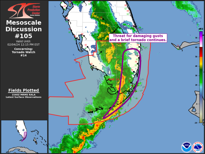
   Mesoscale Discussion 0105
   NWS Storm Prediction Center Norman OK
   0941 AM CST Sun Feb 04 2024

   Areas affected...South FL and the Upper FL Keys

   Concerning...Tornado Watch 14...

   Valid 041541Z - 041715Z

   The severe weather threat for Tornado Watch 14 continues.

   SUMMARY...Threat for damaging wind gusts and a brief tornado
   continues across south Florida and the Upper Florida Keys.

   DISCUSSION...Regional radar imagery continues to show a convective
   line extending southward from central FL into far south FL and then
   back southwestward through the Middle Keys. Buoyancy ahead of this
   line remains limited by poor lapse rates and only marginally
   warm/moist surface conditions. This limited buoyancy has tempered
   overall storm intensity/depth, with a generally shallow character to
   much of the convection. Even so, given the robust low to mid-level
   flow in place, a few stronger gusts have still been reported,
   including 36 and 37 kt at NQX and MTH, respectively. This trend is
   forecast to continue for the next hour/hour and a half before the
   line moves offshore. Recent KAMX does show a vertically veering
   low-level wind profile supportive of a brief tornado or two if
   greater updraft depth can be maintained.

   ..Mosier.. 02/04/2024

   ...Please see www.spc.noaa.gov for graphic product...

   ATTN...WFO...MFL...KEY...

   LAT...LON   24378130 24968084 25728069 26148065 26448059 26528022
               26278004 25508015 24908053 24378130
|
|
Top/All Mesoscale Discussions/Forecast Products/Home
|
|


 @NWSSPC