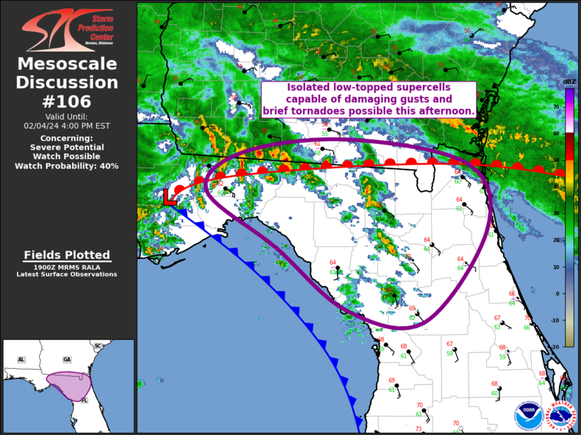
   Mesoscale Discussion 0106
   NWS Storm Prediction Center Norman OK
   0101 PM CST Sun Feb 04 2024

   Areas affected...Eastern FL Panhandle into Northern FL and Far
   Southeast GA

   Concerning...Severe potential...Watch possible

   Valid 041901Z - 042100Z

   Probability of Watch Issuance...40 percent

   SUMMARY...Isolated low-topped supercells capable of damaging gusts
   and brief tornadoes are possible across northern FL and far southern
   GA this afternoon.

   DISCUSSION...Recent surface analysis places a low about 35 miles
   north of AAF in the central FL Panhandle. A warm from extends
   east-northeastward from this low into extreme southeast GA/northeast
   FL, while a cold front arcs southeastward to the Tampa Bay vicinity,
   remaining mostly offshore. Radar imagery from KTLH has shown several
   low-topped rotating storms near the warm front just east/northeast
   of TLH. Given the lack of buoyancy, updrafts are likely being
   augmented by favorable interaction with the warm front, with the
   strong low-level shear then resulting in tornadogenesis. Additional
   development is occurring south of the warm front, and there is some
   chance that continued interaction with the warm front could result
   in another brief tornado.

   A somewhat separate regime is developing within the warm sector
   downstream of the approaching Pacific cold front. Clearing within
   the dry slot is allowing for filtered heating and steepening of the
   low-level lapse rates. At the same time, cold mid-level temperatures
   continue to advect over the region, with 500-mb temperatures likely
   dropping to -20 deg C across much of northern FL by later this
   afternoon. Shallow thunderstorm development is expected along and
   ahead of the front across northern FL this afternoon. Veering
   low-level flow will be in place, and the potential for a few
   low-topped supercells exists. However, buoyancy will be modest and
   is expected to limit both updraft strength and duration, leading to
   uncertainty on the number and coverage of supercells. This
   uncertainty tempers the overall watch probability, but convective
   trends will be monitored closely this afternoon for potential watch
   issuance.

   ..Mosier/Goss.. 02/04/2024

   ...Please see www.spc.noaa.gov for graphic product...

   ATTN...WFO...TBW...JAX...TAE...

   LAT...LON   30358457 30748417 30868296 30628162 29968143 29088214
               29198300 29808378 30358457
|


 @NWSSPC