 Note:
The expiration time in the watch graphic is amended if the watch is
replaced, cancelled or extended.
Note:
Note:
The expiration time in the watch graphic is amended if the watch is
replaced, cancelled or extended.
Note: Click for
Watch Status Reports.
SEL4
URGENT - IMMEDIATE BROADCAST REQUESTED
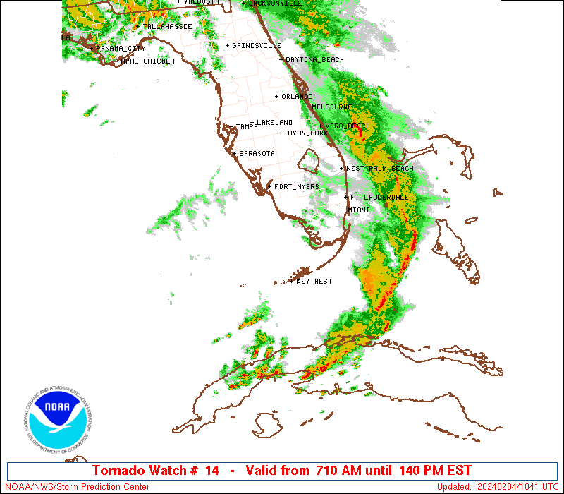
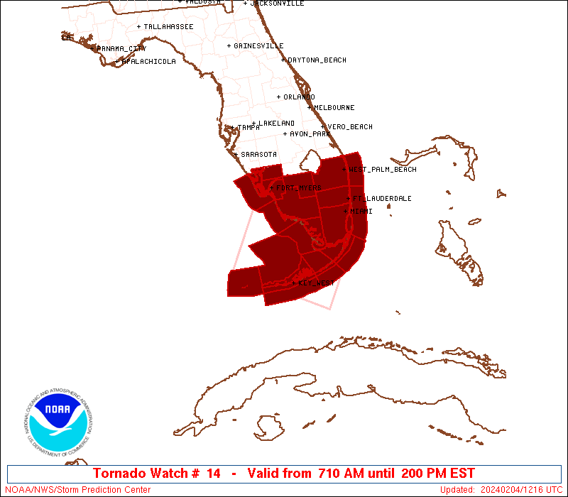
Tornado Watch Number 14
NWS Storm Prediction Center Norman OK
710 AM EST Sun Feb 4 2024
The NWS Storm Prediction Center has issued a
* Tornado Watch for portions of
Southern Florida Peninsula and the Keys
Coastal Waters
* Effective this Sunday morning and afternoon from 710 AM until
200 PM EST.
* Primary threats include...
A couple tornadoes possible
Scattered damaging wind gusts to 70 mph possible
Isolated large hail events to 1 inch in diameter possible
SUMMARY...A complex of strong-severe thunderstorms is expected to
sweep eastward across mainland southern FL and the Keys through
early afternoon, with damaging gusts and a couple tornadoes
possible.
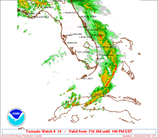
The tornado watch area is approximately along and 75 statute miles
either side of a line from 55 miles northwest of Miami FL to 20
miles west southwest of Key West FL. For a complete depiction of the
watch see the associated watch outline update (WOUS64 KWNS WOU4).
PRECAUTIONARY/PREPAREDNESS ACTIONS...
REMEMBER...A Tornado Watch means conditions are favorable for
tornadoes and severe thunderstorms in and close to the watch
area. Persons in these areas should be on the lookout for
threatening weather conditions and listen for later statements
and possible warnings.
&&
AVIATION...Tornadoes and a few severe thunderstorms with hail
surface and aloft to 1 inch. Extreme turbulence and surface wind
gusts to 60 knots. A few cumulonimbi with maximum tops to 450. Mean
storm motion vector 27035.
...Edwards
   SEL4

   URGENT - IMMEDIATE BROADCAST REQUESTED
   Tornado Watch Number 14
   NWS Storm Prediction Center Norman OK
   710 AM EST Sun Feb 4 2024

   The NWS Storm Prediction Center has issued a

   * Tornado Watch for portions of
     Southern Florida Peninsula and the Keys
     Coastal Waters

   * Effective this Sunday morning and afternoon from 710 AM until
     200 PM EST.

   * Primary threats include...
     A couple tornadoes possible
     Scattered damaging wind gusts to 70 mph possible
     Isolated large hail events to 1 inch in diameter possible

   SUMMARY...A complex of strong-severe thunderstorms is expected to
   sweep eastward across mainland southern FL and the Keys through
   early afternoon, with damaging gusts and a couple tornadoes
   possible.

   The tornado watch area is approximately along and 75 statute miles
   either side of a line from 55 miles northwest of Miami FL to 20
   miles west southwest of Key West FL. For a complete depiction of the
   watch see the associated watch outline update (WOUS64 KWNS WOU4).

   PRECAUTIONARY/PREPAREDNESS ACTIONS...

   REMEMBER...A Tornado Watch means conditions are favorable for
   tornadoes and severe thunderstorms in and close to the watch
   area. Persons in these areas should be on the lookout for
   threatening weather conditions and listen for later statements
   and possible warnings.

   &&

   AVIATION...Tornadoes and a few severe thunderstorms with hail
   surface and aloft to 1 inch. Extreme turbulence and surface wind
   gusts to 60 knots. A few cumulonimbi with maximum tops to 450. Mean
   storm motion vector 27035.

   ...Edwards
 Note:
The Aviation Watch (SAW) product is an approximation to the watch area.
The actual watch is depicted by the shaded areas.
Note:
The Aviation Watch (SAW) product is an approximation to the watch area.
The actual watch is depicted by the shaded areas.
SAW4
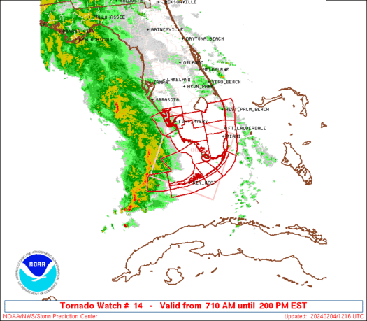
WW 14 TORNADO FL CW 041210Z - 041900Z
AXIS..75 STATUTE MILES EITHER SIDE OF LINE..
55NW MIA/MIAMI FL/ - 20WSW EYW/KEY WEST FL/
..AVIATION COORDS.. 65NM EITHER SIDE /47NW MIA - 17WSW EYW/
HAIL SURFACE AND ALOFT..1 INCH. WIND GUSTS..60 KNOTS.
MAX TOPS TO 450. MEAN STORM MOTION VECTOR 27035.
LAT...LON 25817987 23898104 24988310 26908196
THIS IS AN APPROXIMATION TO THE WATCH AREA. FOR A
COMPLETE DEPICTION OF THE WATCH SEE WOUS64 KWNS
FOR WOU4.
Watch 14 Status Report Messages:
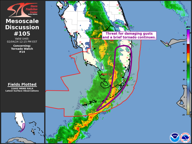
STATUS REPORT #2 ON WW 14

VALID 041725Z - 041840Z

SEVERE WEATHER THREAT CONTINUES RIGHT OF A LINE FROM 35 SSE MIA
TO 5 ENE MIA TO 25 NNW MIA.

..MOSIER..02/04/24

ATTN...WFO...MFL...TBW...KEY...

&&

STATUS REPORT FOR WT 14

SEVERE WEATHER THREAT CONTINUES FOR THE FOLLOWING AREAS

FLC099-041840-

FL
.    FLORIDA COUNTIES INCLUDED ARE

PALM BEACH
$$


AMZ650-651-041840-

CW

.    ADJACENT COASTAL WATERS INCLUDED ARE

COASTAL WATERS FROM JUPITER INLET TO DEERFIELD BEACH FL OUT 20 NM

COASTAL WATERS FROM DEERFIELD BEACH TO OCEAN REEF FL OUT 20 NM

$$
THE WATCH STATUS MESSAGE IS FOR GUIDANCE PURPOSES ONLY.  PLEASE
REFER TO WATCH COUNTY NOTIFICATION STATEMENTS FOR OFFICIAL
INFORMATION ON COUNTIES...INDEPENDENT CITIES AND MARINE ZONES
CLEARED FROM SEVERE THUNDERSTORM AND TORNADO WATCHES.
$$

STATUS REPORT #1 ON WW 14

VALID 041520Z - 041640Z

SEVERE WEATHER THREAT CONTINUES RIGHT OF A LINE FROM 30 SW EYW TO
25 SW EYW TO 25 NNW MTH TO 50 N MTH TO 45 W MIA TO 35 E FMY.

..MOSIER..02/04/24

ATTN...WFO...MFL...TBW...KEY...

&&

STATUS REPORT FOR WT 14

SEVERE WEATHER THREAT CONTINUES FOR THE FOLLOWING AREAS

FLC011-051-086-087-099-041640-

FL
.    FLORIDA COUNTIES INCLUDED ARE

BROWARD 	     HENDRY		 MIAMI-DADE
MONROE		     PALM BEACH
$$


AMZ630-650-651-GMZ031-032-042-043-044-052-053-054-041640-

CW

.    ADJACENT COASTAL WATERS INCLUDED ARE

BISCAYNE BAY

COASTAL WATERS FROM JUPITER INLET TO DEERFIELD BEACH FL OUT 20 NM

COASTAL WATERS FROM DEERFIELD BEACH TO OCEAN REEF FL OUT 20 NM

FLORIDA BAY INCLUDING BARNES SOUND BLACKWATER SOUND AND
BUTTONWOOD SOUND

BAYSIDE AND GULF SIDE FROM CRAIG KEY TO WEST END OF SEVEN MILE
BRIDGE

HAWK CHANNEL FROM OCEAN REEF TO CRAIG KEY OUT TO THE REEF

HAWK CHANNEL FROM CRAIG KEY TO WEST END OF SEVEN MILE BRIDGE OUT
TO THE REEF

HAWK CHANNEL FROM WEST END OF SEVEN MILE BRIDGE TO HALFMOON SHOAL
OUT TO THE REEF

STRAITS OF FLORIDA FROM OCEAN REEF TO CRAIG KEY OUT 20 NM

STRAITS OF FLORIDA FROM CRAIG KEY TO WEST END OF SEVEN MILE
BRIDGE OUT 20 NM

STRAITS OF FLORIDA FROM WEST END OF SEVEN MILE BRIDGE TO SOUTH OF
HALFMOON SHOAL OUT 20 NM

$$
THE WATCH STATUS MESSAGE IS FOR GUIDANCE PURPOSES ONLY.  PLEASE
REFER TO WATCH COUNTY NOTIFICATION STATEMENTS FOR OFFICIAL
INFORMATION ON COUNTIES...INDEPENDENT CITIES AND MARINE ZONES
CLEARED FROM SEVERE THUNDERSTORM AND TORNADO WATCHES.
$$
Note:
Click for Complete Product Text.
Tornadoes
Probability of 2 or more tornadoes
|
Mod (30%)
|
Probability of 1 or more strong (EF2-EF5) tornadoes
|
Low (10%)
|
Wind
Probability of 10 or more severe wind events
|
Mod (40%)
|
Probability of 1 or more wind events > 65 knots
|
Low (10%)
|
Hail
Probability of 10 or more severe hail events
|
Low (20%)
|
Probability of 1 or more hailstones > 2 inches
|
Low (10%)
|
Combined Severe Hail/Wind
Probability of 6 or more combined severe hail/wind events
|
High (70%)
|
For each watch, probabilities for particular events inside the watch
(listed above in each table) are determined by the issuing forecaster.
The "Low" category contains probability values ranging from less than 2%
to 20% (EF2-EF5 tornadoes), less than 5% to 20% (all other probabilities),
"Moderate" from 30% to 60%, and "High" from 70% to greater than 95%.
High values are bolded and lighter in color to provide awareness of
an increased threat for a particular event.


 @NWSSPC