|
| Mesoscale Discussion 104 |
|
< Previous MD Next MD >
|
|
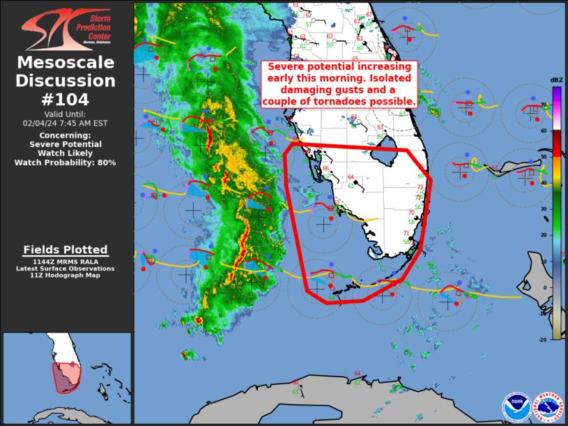
   Mesoscale Discussion 0104
   NWS Storm Prediction Center Norman OK
   0545 AM CST Sun Feb 04 2024

   Areas affected...portions of south FL and the FL Keys

   Concerning...Severe potential...Watch likely

   Valid 041145Z - 041245Z

   Probability of Watch Issuance...80 percent

   SUMMARY...Severe-thunderstorm potential will increase through early
   morning as a line of convection develops eastward toward the
   southwest FL coast and the Keys. Isolated damaging gusts and a
   couple of tornadoes are possible. A watch will likely be needed by
   13z.

   DISCUSSION...A line of convection associated with an eastward-
   developing MCS over the eastern Gulf of Mexico will approach the
   southwest FL coast and the Keys over the next few hours.
   Boundary-layer dewpoints remain modest, in the upper 50s to low 60s
   F. Only minor increases in surface dewpoints are expected before
   convection begins moving across the southern Peninsula. Rather
   modest moisture and poor low-level lapse rates will limit
   instability, with generally less than 500-1000 J/kg MLCAPE expected.

   Nevertheless, 0-6 km bulk effective shear values around 35-45 kt
   will support organized convection. Regional VWP data indicate
   somewhat enlarged and curved low-level hodographs becoming elongated
   above 2-3 km. This should support at least transient strong to
   severe storms posing a risk for damaging gusts within the convective
   line. Although low-level moisture/thermodynamics are forecast to
   remain weak, favorable shear may still be sufficient for a couple of
   tornadoes, especially over the Keys or the far south Peninsula where
   surface dewpoints may approach 63-65 F through late morning.

   ..Leitman/Edwards.. 02/04/2024

   ...Please see www.spc.noaa.gov for graphic product...

   ATTN...WFO...MFL...MLB...KEY...TBW...

   LAT...LON   27078258 26958043 26447999 25288019 24798053 24428125
               24388192 24588229 26358270 26898273 27078258
|
|
Top/All Mesoscale Discussions/Forecast Products/Home
|
|


 @NWSSPC