|
| Mesoscale Discussion 544 |
|
< Previous MD Next MD >
|
|
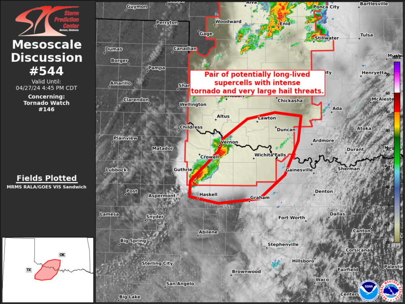
   Mesoscale Discussion 0544
   NWS Storm Prediction Center Norman OK
   0319 PM CDT Sat Apr 27 2024

   Areas affected...Western north TX and southwest OK

   Concerning...Tornado Watch 146...

   Valid 272019Z - 272145Z

   The severe weather threat for Tornado Watch 146 continues.

   SUMMARY...Pair of potentially long-lived supercells within the
   southern portion of WW 146 may evolve with an intense tornado and
   very large hail threat.

   DISCUSSION...A potentially long-lived, slow-moving discrete
   supercell is centered over Knox County, TX. This supercell appears
   to be anchored along the far southern portion of the broader
   convective plume that extends north across OK/KS. With full
   insolation in the warm-moist sector inflow to its southeast, its
   plausible that a long-lived supercell will persist for the next 2-3
   hours. Amid MLCAPE of 3000 J/kg and mid 60s surface dew points to
   its southeast, a cyclic tornadic supercell could evolve beyond the
   very large hail threat with up to baseballs reported thus far. The
   supercell to its northeast in Wilbarger County, TX will also have
   potential to further intensify as it spreads towards and northwest
   of the Wichita Falls vicinity, given 0-1 km SRH of 100-200 m2/s2 per
   FDR VWP data.

   ..Grams.. 04/27/2024

   ...Please see www.spc.noaa.gov for graphic product...

   ATTN...WFO...FWD...OUN...SJT...

   LAT...LON   34049929 34279919 34669862 34789799 34719739 34239746
               33609778 33159835 33059928 33179992 33479991 34049929
|
|
Top/All Mesoscale Discussions/Forecast Products/Home
|
|


 @NWSSPC