|
| Mesoscale Discussion 541 |
|
< Previous MD Next MD >
|
|
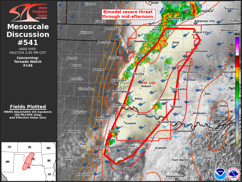
   Mesoscale Discussion 0541
   NWS Storm Prediction Center Norman OK
   0113 PM CDT Sat Apr 27 2024

   Areas affected...Northwest TX to north-central OK

   Concerning...Tornado Watch 146...

   Valid 271813Z - 271945Z

   The severe weather threat for Tornado Watch 146 continues.

   SUMMARY...Near-term severe threat appears bimodal with discrete
   supercells from northwest Texas into southwest Oklahoma, and
   separately in north-central Oklahoma with supercells embedded within
   a slow-moving cluster.

   DISCUSSION...A trio of discrete supercells are ongoing across a part
   of northwest TX into far southwest OK, just ahead of the pronounced
   dryline. The relatively most favorable thermodynamic environment is
   just ahead of these cells. Large hail will be the primary initial
   threat, but as supercells mature, the tornado threat should
   correspondingly increase amid 0-1 km SRH of 100-200 m2/s2 per FDR
   VWP data.

   Long-lived cluster with embedded supercell structures has gradually
   progressed northeastward over northwest into north-central OK. This
   has left a substantial cold pool in its wake with surface
   temperatures in the upper 50s to low 60s, minimizing the severe
   threat to its northwest in the near-term. Given the cluster
   aligning nearly parallel to the deep-layer shear vector, the primary
   severe threat will likely be confined along the immediate leading
   edge of this cluster within small-scale bowing structures
   approaching the I-35 corridor.

   ..Grams.. 04/27/2024

   ...Please see www.spc.noaa.gov for graphic product...

   ATTN...WFO...TSA...FWD...OUN...SJT...LUB...

   LAT...LON   33490031 34609970 35809921 36369852 36919814 36879703
               36529679 35539765 34439786 32939939 32650001 32950044
               33490031
|
|
Top/All Mesoscale Discussions/Forecast Products/Home
|
|


 @NWSSPC