|
| Mesoscale Discussion 540 |
|
< Previous MD Next MD >
|
|
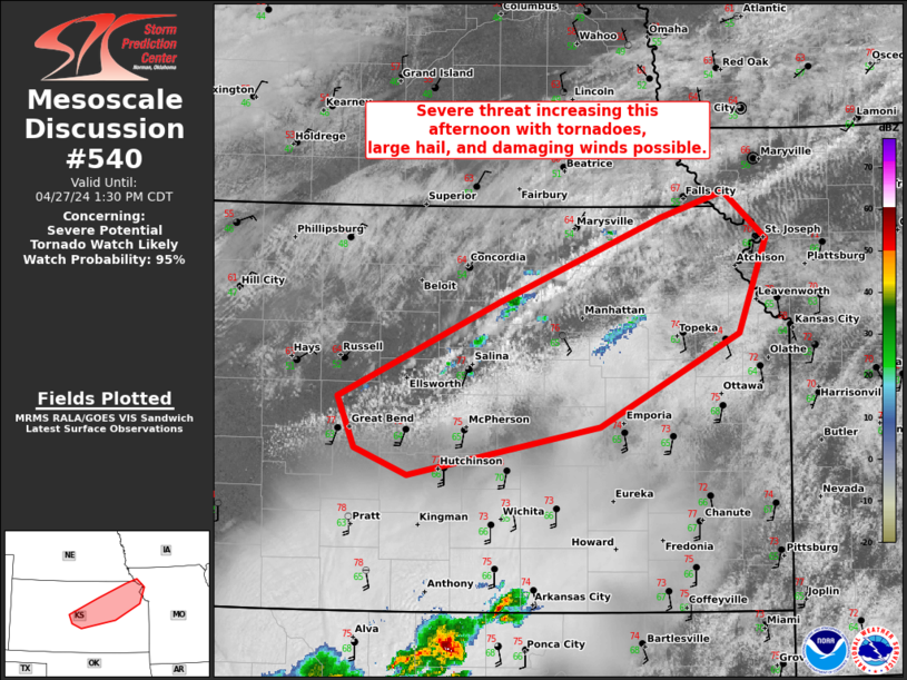
   Mesoscale Discussion 0540
   NWS Storm Prediction Center Norman OK
   1133 AM CDT Sat Apr 27 2024

   Areas affected...Central to northeast KS

   Concerning...Severe potential...Tornado Watch likely

   Valid 271633Z - 271830Z

   Probability of Watch Issuance...95 percent

   SUMMARY...Severe storms are expected to develop during the early to
   mid-afternoon along the surface front across central to northeast
   Kansas. Tornadoes, large hail, and damaging winds will all be
   possible.

   DISCUSSION...16Z surface analysis placed a quasi-stationary front
   across central to northeast KS. A swelling CU field with embedded
   small CBs have initiated along the portion of the front just north
   of SLN to MHK. With minimal warm-sector MLCIN amid 65-66 F surface
   dew points, convective development will increase into early
   afternoon. Primary uncertainty is the degree of sustained convective
   coverage. With the deep-layer shear vector oriented roughly parallel
   to the front, a cluster-type mode may eventually dominate. But given
   that large-scale ascent is relatively weak through the afternoon,
   it's plausible that a more discrete supercell mode could be
   maintained for several hours. With 40-45 kt south-southwesterly
   low-level flow per the ICT VWP data, all severe hazards will be
   possible, including the potential for a strong tornado or two later
   this afternoon.

   ..Grams.. 04/27/2024

   ...Please see www.spc.noaa.gov for graphic product...

   ATTN...WFO...EAX...OAX...TOP...ICT...DDC...

   LAT...LON   39309733 39919582 40109521 39769481 39069508 38379640
               38009822 38219871 38599887 39309733
|
|
Top/All Mesoscale Discussions/Forecast Products/Home
|
|


 @NWSSPC