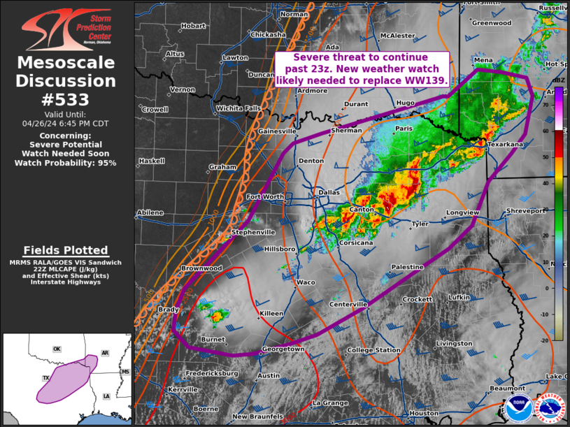
   Mesoscale Discussion 0533
   NWS Storm Prediction Center Norman OK
   0513 PM CDT Fri Apr 26 2024

   Areas affected...central Texas...southeastern Oklahoma...Arklatex

   Concerning...Severe potential...Watch needed soon

   Valid 262213Z - 262345Z

   Probability of Watch Issuance...95 percent

   SUMMARY...The severe threat will likely continue past 23z. New
   weather watch will be needed to replace WW139 soon.

   DISCUSSION...A cluster of storms is ongoing from Forreston, TX to
   Sulphur Springs, TX. These storms have produced reports of hail with
   transient rotation embedded with the line. This complex has modified
   the airmass, which is apparent in surface observations and visible
   satellite. This cluster will likely continue to maintain severe
   intensity with potential for damaging wind, hail, and a tornado as
   it moves northeastward within the core of the low-level jet into the
   Arklatex region.

   Further west along a surface dryline, agitated cu can be observed
   with potential for new thunderstorm development in the next couple
   of hours. Given the modified airmass to the north and northeast of
   ongoing convection, the best potential for new development of strong
   thunderstorms will be along the southwestern fringe of WW139. This
   area will become increasingly displaced from the low-level jet
   through the evening, but will still reside in a region of unstable
   air, amid steep lapse rates and strong deep layer shear. These
   storms will be capable of very large hail and damaging winds, and
   perhaps a tornado. A new weather watch will be needed to encompass
   this threat soon.

   ..Thornton/Edwards.. 04/26/2024

   ...Please see www.spc.noaa.gov for graphic product...

   ATTN...WFO...LZK...SHV...TSA...HGX...FWD...OUN...EWX...SJT...

   LAT...LON   31219903 31509891 32459791 33379736 33529719 33669673
               33759634 34159474 34169465 34519415 34479377 34389334
               34149325 33619340 33359363 32979402 32379430 32079467
               31819511 31259607 30899679 30769721 30639779 30609812
               30709881 30929906 31219903
|


 @NWSSPC