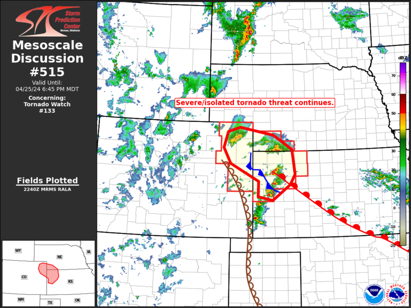
   Mesoscale Discussion 0515
   NWS Storm Prediction Center Norman OK
   0542 PM CDT Thu Apr 25 2024

   Areas affected...(northeastern Colorado...southwestern
   Nebraska...and northwestern Kansas

   Concerning...Tornado Watch 133...

   Valid 252242Z - 260045Z

   The severe weather threat for Tornado Watch 133 continues.

   SUMMARY...Severe/local tornado risk continues within WW 133, across
   northwestern Kansas, northeastern Colorado, and southwestern
   Nebraska early this evening.

   DISCUSSION...Latest radar loop shows numerous strong/severe storms
   developing from just southeast of GLD southward across western
   Kansas (into Tornado Watch 134), near and ahead of a dryline
   analyzed over far eastern Colorado.  Meanwhile, additional
   strong/severe storms are ongoing from near the surface low over
   northeastern Colorado, east-southeastward across southwestern
   Nebraska and adjacent northwestern Kansas -- to the cool side of a
   warm front bisecting Kansas from northwest to southeast.

   An axis of moderate instability (2000 to 3000 J/kg mixed-layer CAPE)
   is indicated across the warm sector, bounded by the dryline on the
   west, and the warm front on the northeast.  South-southeasterly
   low-level flow across this area (veering to east-southeasterly north
   of the warm front) beneath mid-level south-southwesterlies near 50
   kt, is yielding favorable shear for rotating storms -- confirming
   radar observations.

   Storms moving north-northeastward out of northwestern Kansas into
   southwestern Nebraska should weaken with time, as they move into a
   more stable airmass north of the warm front.  Meanwhile, storms
   nearer the front, and southward along the dryline, will remain
   capable of producing very large hail (up to around baseball size)
   and locally damaging wind gusts.  Tornado risk also remains evident,
   and should increase this evening as a south-southeasterly low-level
   jet ramps up to in excess of 50 kt with time.

   ..Goss.. 04/25/2024

   ...Please see www.spc.noaa.gov for graphic product...

   ATTN...WFO...LBF...DDC...GLD...BOU...

   LAT...LON   40680315 40820262 40550112 40060029 39200017 38830039
               38300115 38430181 38950179 39580303 40130334 40680315
|


 @NWSSPC