|
| Mesoscale Discussion 500 |
|
< Previous MD Next MD >
|
|
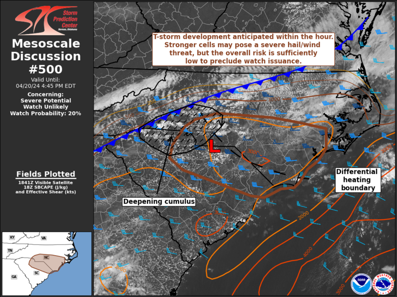
   Mesoscale Discussion 0500
   NWS Storm Prediction Center Norman OK
   0145 PM CDT Sat Apr 20 2024

   Areas affected...Northern South Carolina into southern North
   Carolina

   Concerning...Severe potential...Watch unlikely

   Valid 201845Z - 202045Z

   Probability of Watch Issuance...20 percent

   SUMMARY...Thunderstorm development is anticipated within the next
   hour. A few strong/severe cells, including the potential for a
   supercell or two, will pose a severe hail/wind threat to parts of
   the Carolinas this afternoon and evening. This threat should remain
   fairly localized; watch issuance is not anticipated.

   DISCUSSION...Steady growth of multiple cumulus congestus has been
   noted in GOES imagery over the past 30-60 minutes along a cold front
   and in the vicinity of a weak surface low across parts of the
   Carolinas. Glaciation is noted in a few of the deeper towers,
   suggesting that thunderstorm initiation is probable within the next
   hour or so. Discrete to semi-discrete cells that emerge from within
   the growing cumulus field will likely propagate off the slow-moving
   cold front into an increasingly buoyant air mass downstream into the
   eastern Carolinas (where MLCAPE is increasing to around 1500 J/kg).
   Within the past hour regional VWPs sampled weak winds through the
   lowest few kilometers, but a nearly uni-directional wind profile
   with 40-50 knot flow between 5-6 km. This is yielding 0-6 km BWD
   values on the order of 30-40 knots with a wind profile favorable for
   splitting cells. Consequently, this environment appears supportive
   of supercells with an attendant large hail (0.75 to 1.25 inch in
   diameter) and severe wind risk. The hail risk might be regionally
   maximized across parts of NC to the north of a differential heating
   boundary where muted diurnal mixing is supporting higher buoyancy.
   Conversely, areas to the south of this boundary may see a higher
   damaging wind threat given steeper low-level lapse rates.
   Regardless, it remains unclear how many cells will emerge from the
   cumulus field and evolve into mature supercells given the weak
   forcing for ascent. Latest CAM guidance also suggests storm coverage
   may be limited, which lends credence to the idea that the overall
   severe threat should remain sufficiently localized to preclude the
   need for a watch.

   ..Moore/Goss.. 04/20/2024

   ...Please see www.spc.noaa.gov for graphic product...

   ATTN...WFO...MHX...RAH...ILM...CAE...GSP...

   LAT...LON   33607884 33637921 34248114 34508152 34848145 35258111
               35438081 35598018 35497859 35367780 35217705 34747706
               34457730 34257759 33957784 33837798 33797836 33677863
               33607884
|
|
Top/All Mesoscale Discussions/Forecast Products/Home
|
|


 @NWSSPC