|
| Mesoscale Discussion 451 |
|
< Previous MD Next MD >
|
|
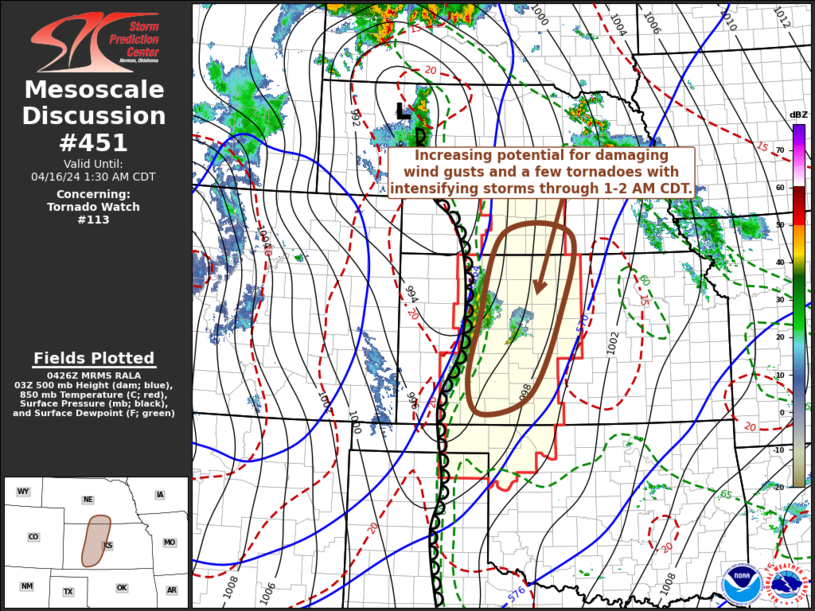
   Mesoscale Discussion 0451
   NWS Storm Prediction Center Norman OK
   1129 PM CDT Mon Apr 15 2024

   Areas affected...parts of western and central Kansas and adjacent
   south central Nebraska

   Concerning...Tornado Watch 113...

   Valid 160429Z - 160630Z

   The severe weather threat for Tornado Watch 113 continues.

   SUMMARY...An increasing risk for damaging wind gusts and a few
   tornadoes appears probable with an intensifying line of
   thunderstorms across western into central Kansas and adjacent south
   central Nebraska through 1-2 AM CDT.

   DISCUSSION...A strong cyclonic upper jet streak continues to nose
   across the southern Rockies through the south central high plains,
   with latest  Rapid Refresh suggesting speeds now in the process of
   strengthening in excess of 80 to 90+ kt across the Texas Panhandle
   through northwestern Oklahoma.  Strongest mid-level cooling in the
   exit region of this feature (including 500 mb temperatures
   decreasing to -20 to -22c) is forecast to overspread the stalling
   dryline across western Kansas through 05-07Z, contributing to
   weakening of lingering mid-level inhibition, further destabilization
   and more rapid thunderstorm intensification.

   Persistence of the ongoing isolated supercell now approaching the
   Hayes/Russell vicinity, within the narrow corridor of moderate
   potential instability ahead of the dryline, remains unclear, but
   further intensification of the linear structure along the dryline
   and merging cold fronts now west of Hill City into areas east of
   Garden City seems probable.  Several low-level cyclonic meso
   circulations have already been noted in the presence of enlarged
   clockwise-curved low-level hodographs, beneath a 50-60 kt southerly
   850 mb jet.  With further weakening of inhibition and release of
   CAPE in excess of 2000 J/kg, rapid thunderstorm intensification may
   be accompanied by an increasing risk for tornadoes and damaging wind
   gusts within the next few hours.

   ..Kerr.. 04/16/2024

   ...Please see www.spc.noaa.gov for graphic product...

   ATTN...WFO...ICT...GID...DDC...GLD...

   LAT...LON   38790023 40399968 40359814 38919841 37509910 37190019
               37730048 38790023
|
|
Top/All Mesoscale Discussions/Forecast Products/Home
|
|


 @NWSSPC