 Note:
The expiration time in the watch graphic is amended if the watch is
replaced, cancelled or extended.
Note:
Note:
The expiration time in the watch graphic is amended if the watch is
replaced, cancelled or extended.
Note: Click for
Watch Status Reports.
SEL3
URGENT - IMMEDIATE BROADCAST REQUESTED
Tornado Watch Number 113
NWS Storm Prediction Center Norman OK
805 PM CDT Mon Apr 15 2024
The NWS Storm Prediction Center has issued a
* Tornado Watch for portions of
Western and central Kansas
South central Nebraska
Northwest Oklahoma and the eastern Oklahoma Panhandle
The northeast Texas Panhandle
* Effective this Monday night and Tuesday morning from 805 PM
until 300 AM CDT.
* Primary threats include...
A few tornadoes likely with a couple intense tornadoes possible
Scattered large hail and isolated very large hail events to 3
inches in diameter likely
Scattered damaging winds likely with isolated significant gusts
to 75 mph possible
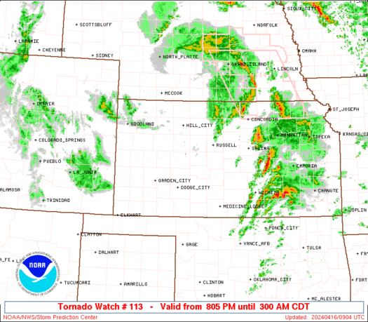
SUMMARY...Thunderstorm development is expected this evening along a
dryline from the Texas Panhandle into western Kansas, with an
environment that will become more favorable for tornadic supercells
after dark. A couple of strong tornadoes will be possible with the
more discrete/persistent supercells, along with very large hail up
to 2.5-3 inches in diameter. Some clustering of storms will be
possible later tonight, with an accompanying threat for damaging
winds of 60-75 mph.
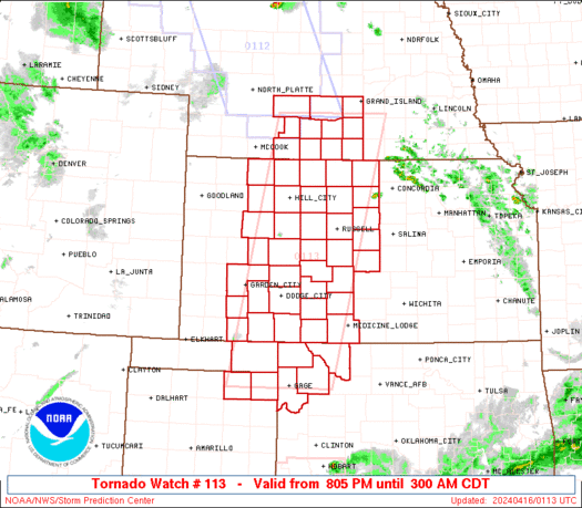
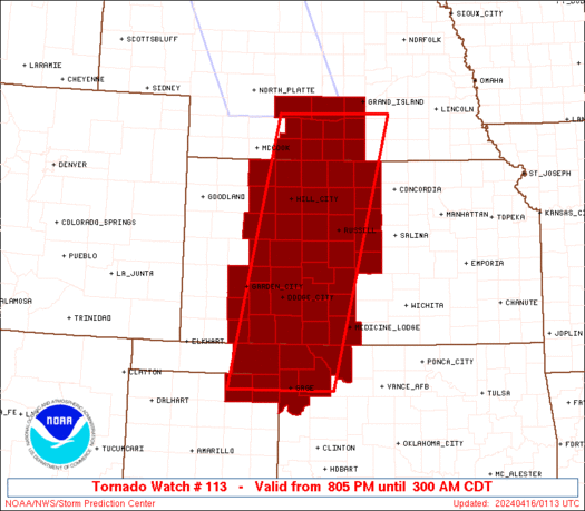
The tornado watch area is approximately along and 60 statute miles
east and west of a line from 5 miles northeast of Kearney NE to 105
miles south of Dodge City KS. For a complete depiction of the watch
see the associated watch outline update (WOUS64 KWNS WOU3).
PRECAUTIONARY/PREPAREDNESS ACTIONS...
REMEMBER...A Tornado Watch means conditions are favorable for
tornadoes and severe thunderstorms in and close to the watch
area. Persons in these areas should be on the lookout for
threatening weather conditions and listen for later statements
and possible warnings.
&&
OTHER WATCH INFORMATION...CONTINUE...WW 109...WW 110...WW
111...WW 112...
AVIATION...Tornadoes and a few severe thunderstorms with hail
surface and aloft to 3 inches. Extreme turbulence and surface wind
gusts to 65 knots. A few cumulonimbi with maximum tops to 500. Mean
storm motion vector 22035.
...Thompson
   SEL3

   URGENT - IMMEDIATE BROADCAST REQUESTED
   Tornado Watch Number 113
   NWS Storm Prediction Center Norman OK
   805 PM CDT Mon Apr 15 2024

   The NWS Storm Prediction Center has issued a

   * Tornado Watch for portions of
     Western and central Kansas
     South central Nebraska
     Northwest Oklahoma and the eastern Oklahoma Panhandle
     The northeast Texas Panhandle

   * Effective this Monday night and Tuesday morning from 805 PM
     until 300 AM CDT.

   * Primary threats include...
     A few tornadoes likely with a couple intense tornadoes possible
     Scattered large hail and isolated very large hail events to 3
       inches in diameter likely
     Scattered damaging winds likely with isolated significant gusts
       to 75 mph possible

   SUMMARY...Thunderstorm development is expected this evening along a
   dryline from the Texas Panhandle into western Kansas, with an
   environment that will become more favorable for tornadic supercells
   after dark.  A couple of strong tornadoes will be possible with the
   more discrete/persistent supercells, along with very large hail up
   to 2.5-3 inches in diameter.  Some clustering of storms will be
   possible later tonight, with an accompanying threat for damaging
   winds of 60-75 mph.

   The tornado watch area is approximately along and 60 statute miles
   east and west of a line from 5 miles northeast of Kearney NE to 105
   miles south of Dodge City KS. For a complete depiction of the watch
   see the associated watch outline update (WOUS64 KWNS WOU3).

   PRECAUTIONARY/PREPAREDNESS ACTIONS...

   REMEMBER...A Tornado Watch means conditions are favorable for
   tornadoes and severe thunderstorms in and close to the watch
   area. Persons in these areas should be on the lookout for
   threatening weather conditions and listen for later statements
   and possible warnings.

   &&

   OTHER WATCH INFORMATION...CONTINUE...WW 109...WW 110...WW
   111...WW 112...

   AVIATION...Tornadoes and a few severe thunderstorms with hail
   surface and aloft to 3 inches. Extreme turbulence and surface wind
   gusts to 65 knots. A few cumulonimbi with maximum tops to 500. Mean
   storm motion vector 22035.

   ...Thompson
 Note:
The Aviation Watch (SAW) product is an approximation to the watch area.
The actual watch is depicted by the shaded areas.
Note:
The Aviation Watch (SAW) product is an approximation to the watch area.
The actual watch is depicted by the shaded areas.
   SAW3
   WW 113 TORNADO KS NE OK TX 160105Z - 160800Z
   AXIS..60 STATUTE MILES EAST AND WEST OF LINE..
   5NE EAR/KEARNEY NE/ - 105S DDC/DODGE CITY KS/
   ..AVIATION COORDS.. 50NM E/W /45SW OBH - 7SW MMB/
   HAIL SURFACE AND ALOFT..3 INCHES. WIND GUSTS..65 KNOTS.
   MAX TOPS TO 500. MEAN STORM MOTION VECTOR 22035.

   LAT...LON 40779779 36259889 36250105 40770008

   THIS IS AN APPROXIMATION TO THE WATCH AREA.  FOR A
   COMPLETE DEPICTION OF THE WATCH SEE WOUS64 KWNS
   FOR WOU3.
Watch 113 Status Report Messages:
STATUS REPORT #5 ON WW 113

VALID 160740Z - 160800Z

SEVERE WEATHER THREAT CONTINUES RIGHT OF A LINE FROM 35 ENE RSL
TO 25 W EAR.

WW 113 IS SCHEDULED TO EXPIRE AT 160800Z.

FOR ADDITIONAL INFORMATION SEE MESOSCALE DISCUSSION 453.

..GRAMS..04/16/24

ATTN...WFO...DDC...ICT...GLD...GID...AMA...OUN...

&&

STATUS REPORT FOR WT 113

SEVERE WEATHER THREAT CONTINUES FOR THE FOLLOWING AREAS

KSC089-123-183-160800-

KS
.    KANSAS COUNTIES INCLUDED ARE

JEWELL		     MITCHELL		 SMITH
$$


NEC001-019-061-079-099-137-181-160800-

NE
.    NEBRASKA COUNTIES INCLUDED ARE

ADAMS		     BUFFALO		 FRANKLIN
HALL		     KEARNEY		 PHELPS
WEBSTER
$$


THE WATCH STATUS MESSAGE IS FOR GUIDANCE PURPOSES ONLY.  PLEASE
REFER TO WATCH COUNTY NOTIFICATION STATEMENTS FOR OFFICIAL
INFORMATION ON COUNTIES...INDEPENDENT CITIES AND MARINE ZONES
CLEARED FROM SEVERE THUNDERSTORM AND TORNADO WATCHES.
$$

STATUS REPORT #4 ON WW 113

VALID 160625Z - 160740Z

SEVERE WEATHER THREAT CONTINUES RIGHT OF A LINE FROM 75 NNW CSM
TO DDC TO 20 E HLC TO 40 SE LBF.

..GRAMS..04/16/24

ATTN...WFO...DDC...ICT...GLD...GID...AMA...OUN...

&&

STATUS REPORT FOR WT 113

SEVERE WEATHER THREAT CONTINUES FOR THE FOLLOWING AREAS

KSC007-009-025-033-047-051-053-057-083-089-097-105-123-141-145-
147-151-159-163-165-167-183-185-160740-

KS
.    KANSAS COUNTIES INCLUDED ARE

BARBER		     BARTON		 CLARK
COMANCHE	     EDWARDS		 ELLIS
ELLSWORTH	     FORD		 HODGEMAN
JEWELL		     KIOWA		 LINCOLN
MITCHELL	     OSBORNE		 PAWNEE
PHILLIPS	     PRATT		 RICE
ROOKS		     RUSH		 RUSSELL
SMITH		     STAFFORD
$$


NEC001-019-047-061-073-079-083-099-137-181-160740-

NE
.    NEBRASKA COUNTIES INCLUDED ARE

ADAMS		     BUFFALO		 DAWSON
FRANKLIN	     GOSPER		 HALL
HARLAN		     KEARNEY		 PHELPS
WEBSTER
$$


OKC045-059-151-153-160740-

OK
.    OKLAHOMA COUNTIES INCLUDED ARE

ELLIS		     HARPER		 WOODS
WOODWARD
$$


THE WATCH STATUS MESSAGE IS FOR GUIDANCE PURPOSES ONLY.  PLEASE
REFER TO WATCH COUNTY NOTIFICATION STATEMENTS FOR OFFICIAL
INFORMATION ON COUNTIES...INDEPENDENT CITIES AND MARINE ZONES
CLEARED FROM SEVERE THUNDERSTORM AND TORNADO WATCHES.
$$

STATUS REPORT #3 ON WW 113

VALID 160535Z - 160640Z

SEVERE WEATHER THREAT CONTINUES RIGHT OF A LINE FROM 75 NW CSM TO
25 SW DDC TO 30 SSW BBW.

FOR ADDITIONAL INFORMATION SEE MESOSCALE DISCUSSION 451.

..GRAMS..04/16/24

ATTN...WFO...DDC...ICT...GLD...GID...AMA...OUN...

&&

STATUS REPORT FOR WT 113

SEVERE WEATHER THREAT CONTINUES FOR THE FOLLOWING AREAS

KSC007-009-025-033-047-051-053-057-065-083-089-097-105-123-135-
137-141-145-147-151-159-163-165-167-183-185-195-160640-

KS
.    KANSAS COUNTIES INCLUDED ARE

BARBER		     BARTON		 CLARK
COMANCHE	     EDWARDS		 ELLIS
ELLSWORTH	     FORD		 GRAHAM
HODGEMAN	     JEWELL		 KIOWA
LINCOLN 	     MITCHELL		 NESS
NORTON		     OSBORNE		 PAWNEE
PHILLIPS	     PRATT		 RICE
ROOKS		     RUSH		 RUSSELL
SMITH		     STAFFORD		 TREGO
$$


NEC001-019-047-061-065-073-079-083-099-137-181-160640-

NE
.    NEBRASKA COUNTIES INCLUDED ARE

ADAMS		     BUFFALO		 DAWSON
FRANKLIN	     FURNAS		 GOSPER
HALL		     HARLAN		 KEARNEY
PHELPS		     WEBSTER
$$


OKC045-059-151-153-160640-

OK
.    OKLAHOMA COUNTIES INCLUDED ARE

ELLIS		     HARPER		 WOODS
WOODWARD
$$


THE WATCH STATUS MESSAGE IS FOR GUIDANCE PURPOSES ONLY.  PLEASE
REFER TO WATCH COUNTY NOTIFICATION STATEMENTS FOR OFFICIAL
INFORMATION ON COUNTIES...INDEPENDENT CITIES AND MARINE ZONES
CLEARED FROM SEVERE THUNDERSTORM AND TORNADO WATCHES.
$$

STATUS REPORT #2 ON WW 113

VALID 160435Z - 160540Z

THE SEVERE WEATHER THREAT CONTINUES ACROSS THE ENTIRE WATCH AREA.

..KERR..04/16/24

ATTN...WFO...DDC...ICT...GLD...GID...AMA...OUN...

&&

STATUS REPORT FOR WT 113

SEVERE WEATHER THREAT CONTINUES FOR THE FOLLOWING AREAS

KSC007-009-025-033-039-047-051-053-055-057-063-065-069-081-083-
089-097-101-105-119-123-135-137-141-145-147-151-159-163-165-167-
175-179-183-185-195-160540-

KS
.    KANSAS COUNTIES INCLUDED ARE

BARBER		     BARTON		 CLARK
COMANCHE	     DECATUR		 EDWARDS
ELLIS		     ELLSWORTH		 FINNEY
FORD		     GOVE		 GRAHAM
GRAY		     HASKELL		 HODGEMAN
JEWELL		     KIOWA		 LANE
LINCOLN 	     MEADE		 MITCHELL
NESS		     NORTON		 OSBORNE
PAWNEE		     PHILLIPS		 PRATT
RICE		     ROOKS		 RUSH
RUSSELL 	     SEWARD		 SHERIDAN
SMITH		     STAFFORD		 TREGO
$$


NEC001-019-047-061-065-073-079-083-099-137-181-160540-

NE
.    NEBRASKA COUNTIES INCLUDED ARE

ADAMS		     BUFFALO		 DAWSON
FRANKLIN	     FURNAS		 GOSPER
HALL		     HARLAN		 KEARNEY
PHELPS		     WEBSTER
$$


OKC007-045-059-151-153-160540-

OK
.    OKLAHOMA COUNTIES INCLUDED ARE

BEAVER		     ELLIS		 HARPER
WOODS		     WOODWARD
$$


TXC295-357-160540-

TX
.    TEXAS COUNTIES INCLUDED ARE

LIPSCOMB	     OCHILTREE
$$


THE WATCH STATUS MESSAGE IS FOR GUIDANCE PURPOSES ONLY.  PLEASE
REFER TO WATCH COUNTY NOTIFICATION STATEMENTS FOR OFFICIAL
INFORMATION ON COUNTIES...INDEPENDENT CITIES AND MARINE ZONES
CLEARED FROM SEVERE THUNDERSTORM AND TORNADO WATCHES.
$$

STATUS REPORT #1 ON WW 113

VALID 160330Z - 160440Z

THE SEVERE WEATHER THREAT CONTINUES ACROSS THE ENTIRE WATCH AREA.

..KERR..04/16/24

ATTN...WFO...DDC...ICT...GLD...GID...AMA...OUN...

&&

STATUS REPORT FOR WT 113

SEVERE WEATHER THREAT CONTINUES FOR THE FOLLOWING AREAS

KSC007-009-025-033-039-047-051-053-055-057-063-065-069-081-083-
089-097-101-105-119-123-135-137-141-145-147-151-159-163-165-167-
175-179-183-185-195-160440-

KS
.    KANSAS COUNTIES INCLUDED ARE

BARBER		     BARTON		 CLARK
COMANCHE	     DECATUR		 EDWARDS
ELLIS		     ELLSWORTH		 FINNEY
FORD		     GOVE		 GRAHAM
GRAY		     HASKELL		 HODGEMAN
JEWELL		     KIOWA		 LANE
LINCOLN 	     MEADE		 MITCHELL
NESS		     NORTON		 OSBORNE
PAWNEE		     PHILLIPS		 PRATT
RICE		     ROOKS		 RUSH
RUSSELL 	     SEWARD		 SHERIDAN
SMITH		     STAFFORD		 TREGO
$$


NEC001-019-047-061-065-073-079-083-099-137-181-160440-

NE
.    NEBRASKA COUNTIES INCLUDED ARE

ADAMS		     BUFFALO		 DAWSON
FRANKLIN	     FURNAS		 GOSPER
HALL		     HARLAN		 KEARNEY
PHELPS		     WEBSTER
$$


OKC007-045-059-151-153-160440-

OK
.    OKLAHOMA COUNTIES INCLUDED ARE

BEAVER		     ELLIS		 HARPER
WOODS		     WOODWARD
$$


TXC295-357-160440-

TX
.    TEXAS COUNTIES INCLUDED ARE

LIPSCOMB	     OCHILTREE
$$


THE WATCH STATUS MESSAGE IS FOR GUIDANCE PURPOSES ONLY.  PLEASE
REFER TO WATCH COUNTY NOTIFICATION STATEMENTS FOR OFFICIAL
INFORMATION ON COUNTIES...INDEPENDENT CITIES AND MARINE ZONES
CLEARED FROM SEVERE THUNDERSTORM AND TORNADO WATCHES.
$$
Note:
Click for Complete Product Text.
Tornadoes
Probability of 2 or more tornadoes
|
Mod (60%)
|
Probability of 1 or more strong (EF2-EF5) tornadoes
|
Mod (40%)
|
Wind
Probability of 10 or more severe wind events
|
Mod (60%)
|
Probability of 1 or more wind events > 65 knots
|
Mod (30%)
|
Hail
Probability of 10 or more severe hail events
|
Mod (60%)
|
Probability of 1 or more hailstones > 2 inches
|
Mod (60%)
|
Combined Severe Hail/Wind
Probability of 6 or more combined severe hail/wind events
|
High (>95%)
|
For each watch, probabilities for particular events inside the watch
(listed above in each table) are determined by the issuing forecaster.
The "Low" category contains probability values ranging from less than 2%
to 20% (EF2-EF5 tornadoes), less than 5% to 20% (all other probabilities),
"Moderate" from 30% to 60%, and "High" from 70% to greater than 95%.
High values are bolded and lighter in color to provide awareness of
an increased threat for a particular event.


 @NWSSPC


