|
| Mesoscale Discussion 446 |
|
< Previous MD Next MD >
|
|
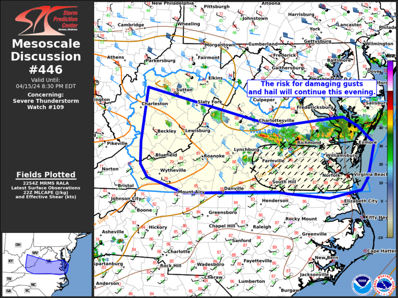
   Mesoscale Discussion 0446
   NWS Storm Prediction Center Norman OK
   0557 PM CDT Mon Apr 15 2024

   Areas affected...eastern Mid Atlantic

   Concerning...Severe Thunderstorm Watch 109...

   Valid 152257Z - 160030Z

   The severe weather threat for Severe Thunderstorm Watch 109
   continues.

   SUMMARY...The risk for damaging gusts and hail continues. Ongoing
   clusters of storms will gradually shift southeast through the
   evening.

   DISCUSSION...As of 2355 UTC, regional radar showed multiple clusters
   of storms, and occasional supercell structures, ongoing across parts
   of central and eastern VA. The environment ahead of these clusters
   remains broadly favorable for damaging winds and hail given 500-1000
   J/kg of MLCAPE and 35-40 kt of effective shear. Recent hi-res
   guidance suggest the ongoing clusters will continue to track
   east/southeast this with gradual upscale growth. Damaging gusts
   appear to be the most likely hazard with storm interactions and
   relatively modest boundary-layer moisture present over parts of
   eastern VA. However, severe hail should still remain possible,
   especially with any supercellular elements, given robust mid-level
   lapse rates of 7-8 C/km. The strongest activity should remain
   focused over the southern half of the Watch area, though more
   isolated development will remain possible on trailing outflow and
   over the higher terrain in western VA/WV through the next few hours.

   ..Lyons.. 04/15/2024

   ...Please see www.spc.noaa.gov for graphic product...

   ATTN...WFO...AKQ...LWX...RNK...RLX...

   LAT...LON   36577794 36558042 36878140 37148159 37638158 38778142
               38107857 37977791 38087685 38147618 37957582 37577537
               36857556 36587574 36427659 36537770 36577794
|
|
Top/All Mesoscale Discussions/Forecast Products/Home
|
|


 @NWSSPC