Note:
The expiration time in the watch graphic is amended if the watch is
replaced, cancelled or extended.
Note:
Note:
The expiration time in the watch graphic is amended if the watch is
replaced, cancelled or extended.
Note: Click for
Watch Status Reports.
SEL9
URGENT - IMMEDIATE BROADCAST REQUESTED
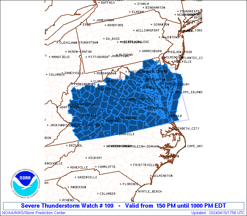
Severe Thunderstorm Watch Number 109
NWS Storm Prediction Center Norman OK
150 PM EDT Mon Apr 15 2024
The NWS Storm Prediction Center has issued a
* Severe Thunderstorm Watch for portions of
District Of Columbia
Southern Delaware
Central and Eastern Maryland
Virginia
Central and Eastern West Virginia
Coastal Waters
* Effective this Monday afternoon and evening from 150 PM until
1000 PM EDT.
* Primary threats include...
Scattered damaging wind gusts to 70 mph likely
Scattered large hail and isolated very large hail events to 2
inches in diameter possible
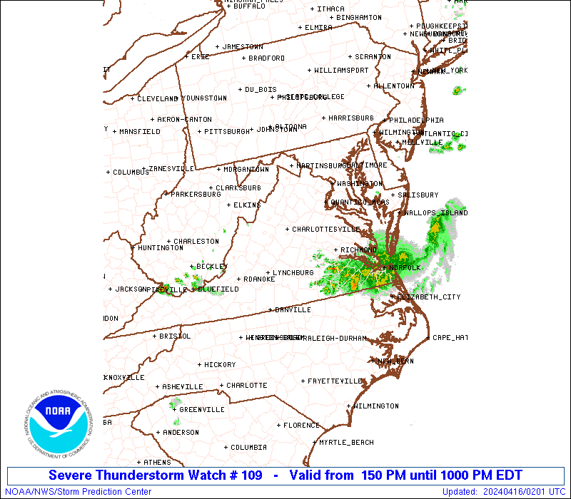
SUMMARY...Broken bands of strong to severe thunderstorms are
forecast to develop this afternoon and move east-southeast through
the mid evening. Scattered severe gusts capable of wind damage will
be possible with the stronger cores and outflow winds. Large hail
may accompany the early cellular storm activity.
The severe thunderstorm watch area is approximately along and 90
statute miles north and south of a line from 20 miles west northwest
of Beckley WV to 30 miles east southeast of Wallops VA. For a
complete depiction of the watch see the associated watch outline
update (WOUS64 KWNS WOU9).
PRECAUTIONARY/PREPAREDNESS ACTIONS...
REMEMBER...A Severe Thunderstorm Watch means conditions are
favorable for severe thunderstorms in and close to the watch area.
Persons in these areas should be on the lookout for threatening
weather conditions and listen for later statements and possible
warnings. Severe thunderstorms can and occasionally do produce
tornadoes.
&&
AVIATION...A few severe thunderstorms with hail surface and aloft to
2 inches. Extreme turbulence and surface wind gusts to 60 knots. A
few cumulonimbi with maximum tops to 500. Mean storm motion vector
29035.
...Smith
 Note:
The Aviation Watch (SAW) product is an approximation to the watch area.
The actual watch is depicted by the shaded areas.
Note:
The Aviation Watch (SAW) product is an approximation to the watch area.
The actual watch is depicted by the shaded areas.
   SAW9
   WW 109 SEVERE TSTM DC DE MD VA WV CW 151750Z - 160200Z
   AXIS..90 STATUTE MILES NORTH AND SOUTH OF LINE..
   20WNW BKW/BECKLEY WV/ - 30ESE WAL/WALLOPS VA/
   ..AVIATION COORDS.. 80NM N/S /17WNW BKW - 44SE SBY/
   HAIL SURFACE AND ALOFT..2 INCHES. WIND GUSTS..60 KNOTS.
   MAX TOPS TO 500. MEAN STORM MOTION VECTOR 29035.

   LAT...LON 39188146 39077496 36467496 36598146

   THIS IS AN APPROXIMATION TO THE WATCH AREA.  FOR A
   COMPLETE DEPICTION OF THE WATCH SEE WOUS64 KWNS
   FOR WOU9.
Watch 109 Status Report Messages:
STATUS REPORT #4 ON WW 109
VALID 160035Z - 160140Z
SEVERE WEATHER THREAT CONTINUES RIGHT OF A LINE FROM 20 S PKB TO
30 SW EKN TO 25 NNE LYH TO 20 ESE RIC TO 35 NNE ORF TO 45 SSE WAL.
..LYONS..04/16/24
ATTN...WFO...LWX...PHI...AKQ...RNK...RLX...
&&
STATUS REPORT FOR WS 109
SEVERE WEATHER THREAT CONTINUES FOR THE FOLLOWING AREAS
VAC005-007-021-025-035-037-045-053-063-067-071-077-081-083-089-
093-095-111-117-121-131-135-141-143-147-149-155-161-173-175-181-
183-185-197-199-550-570-590-595-620-640-650-670-690-700-710-730-
735-740-750-770-775-800-810-830-160140-
VA
. VIRGINIA COUNTIES INCLUDED ARE
ALLEGHANY AMELIA BLAND
BRUNSWICK CARROLL CHARLOTTE
CRAIG DINWIDDIE FLOYD
FRANKLIN GILES GRAYSON
GREENSVILLE HALIFAX HENRY
ISLE OF WIGHT JAMES CITY LUNENBURG
MECKLENBURG MONTGOMERY NORTHAMPTON
NOTTOWAY PATRICK PITTSYLVANIA
PRINCE EDWARD PRINCE GEORGE PULASKI
ROANOKE SMYTH SOUTHAMPTON
SURRY SUSSEX TAZEWELL
WYTHE YORK
VIRGINIA INDEPENDENT CITIES INCLUDED ARE
CHESAPEAKE COLONIAL HEIGHTS DANVILLE
EMPORIA FRANKLIN GALAX
HAMPTON HOPEWELL MARTINSVILLE
NEWPORT NEWS NORFOLK PETERSBURG
POQUOSON PORTSMOUTH RADFORD
ROANOKE SALEM SUFFOLK
VIRGINIA BEACH WILLIAMSBURG
$$
WVC005-007-013-015-019-039-047-055-063-067-075-081-089-101-109-
160140-
WV
. WEST VIRGINIA COUNTIES INCLUDED ARE
BOONE BRAXTON CALHOUN
CLAY FAYETTE KANAWHA
MCDOWELL MERCER MONROE
NICHOLAS POCAHONTAS RALEIGH
SUMMERS WEBSTER WYOMING
$$
ANZ632-634-636-637-638-654-656-160140-
CW
. ADJACENT COASTAL WATERS INCLUDED ARE
CHESAPEAKE BAY FROM NEW POINT COMFORT TO LITTLE CREEK VA
CHESAPEAKE BAY FROM LITTLE CREEK VA TO CAPE HENRY VA INCLUDING
THE CHESAPEAKE BAY BRIDGE TUNNEL
YORK RIVER
JAMES RIVER FROM JAMESTOWN TO THE JAMES RIVER BRIDGE
JAMES RIVER FROM JAMES RIVER BRIDGE TO HAMPTON ROADS
BRIDGE-TUNNEL
COASTAL WATERS FROM PARRAMORE ISLAND TO CAPE CHARLES LIGHT VA OUT
20 NM
COASTAL WATERS FROM CAPE CHARLES LIGHT TO VIRGINIA-NORTH CAROLINA
BORDER OUT TO 20 NM
$$
THE WATCH STATUS MESSAGE IS FOR GUIDANCE PURPOSES ONLY. PLEASE
REFER TO WATCH COUNTY NOTIFICATION STATEMENTS FOR OFFICIAL
INFORMATION ON COUNTIES...INDEPENDENT CITIES AND MARINE ZONES
CLEARED FROM SEVERE THUNDERSTORM AND TORNADO WATCHES.
$$
STATUS REPORT #3 ON WW 109
VALID 152305Z - 160040Z
SEVERE WEATHER THREAT CONTINUES RIGHT OF A LINE FROM 5 SSW PKB TO
15 WSW CHO TO 35 NE RIC TO 45 ENE WAL.
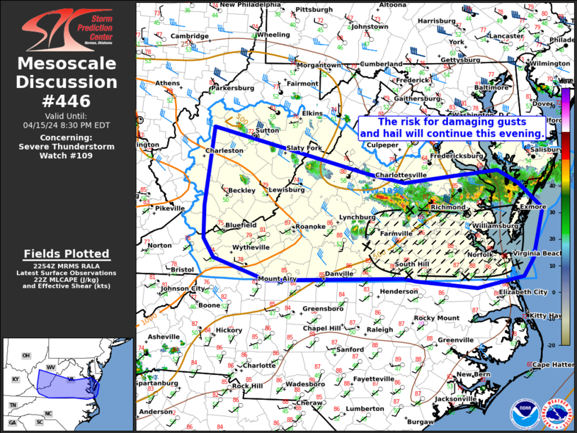
FOR ADDITIONAL INFORMATION SEE MESOSCALE DISCUSSION 446
..SQUITIERI..04/15/24
ATTN...WFO...LWX...PHI...AKQ...RNK...RLX...
&&
STATUS REPORT FOR WS 109
SEVERE WEATHER THREAT CONTINUES FOR THE FOLLOWING AREAS
VAC001-005-007-009-011-015-017-019-021-023-025-029-031-035-036-
037-041-045-049-053-063-065-067-071-073-075-077-081-083-085-087-
089-091-093-095-097-101-103-111-115-117-119-121-125-127-131-133-
135-141-143-145-147-149-155-161-163-173-175-181-183-185-197-199-
530-550-570-580-590-595-620-640-650-670-678-680-690-700-710-730-
735-740-750-760-770-775-790-800-810-820-830-160040-
VA
. VIRGINIA COUNTIES INCLUDED ARE
ACCOMACK ALLEGHANY AMELIA
AMHERST APPOMATTOX AUGUSTA
BATH BEDFORD BLAND
BOTETOURT BRUNSWICK BUCKINGHAM
CAMPBELL CARROLL CHARLES CITY
CHARLOTTE CHESTERFIELD CRAIG
CUMBERLAND DINWIDDIE FLOYD
FLUVANNA FRANKLIN GILES
GLOUCESTER GOOCHLAND GRAYSON
GREENSVILLE HALIFAX HANOVER
HENRICO HENRY HIGHLAND
ISLE OF WIGHT JAMES CITY KING AND QUEEN
KING WILLIAM LANCASTER LUNENBURG
MATHEWS MECKLENBURG MIDDLESEX
MONTGOMERY NELSON NEW KENT
NORTHAMPTON NORTHUMBERLAND NOTTOWAY
PATRICK PITTSYLVANIA POWHATAN
PRINCE EDWARD PRINCE GEORGE PULASKI
ROANOKE ROCKBRIDGE SMYTH
SOUTHAMPTON SURRY SUSSEX
TAZEWELL WYTHE YORK
VIRGINIA INDEPENDENT CITIES INCLUDED ARE
BUENA VISTA CHESAPEAKE COLONIAL HEIGHTS
COVINGTON DANVILLE EMPORIA
FRANKLIN GALAX HAMPTON
HOPEWELL LEXINGTON LYNCHBURG
MARTINSVILLE NEWPORT NEWS NORFOLK
PETERSBURG POQUOSON PORTSMOUTH
RADFORD RICHMOND ROANOKE
SALEM STAUNTON SUFFOLK
VIRGINIA BEACH WAYNESBORO WILLIAMSBURG
$$
WVC005-007-013-015-019-021-025-039-047-055-063-067-075-081-089-
101-109-160040-
WV
. WEST VIRGINIA COUNTIES INCLUDED ARE
BOONE BRAXTON CALHOUN
CLAY FAYETTE GILMER
GREENBRIER KANAWHA MCDOWELL
MERCER MONROE NICHOLAS
POCAHONTAS RALEIGH SUMMERS
WEBSTER WYOMING
$$
ANZ630-631-632-634-635-636-637-638-652-654-656-160040-
CW
. ADJACENT COASTAL WATERS INCLUDED ARE
CHESAPEAKE BAY FROM SMITH POINT TO WINDMILL POINT VA
CHESAPEAKE BAY FROM WINDMILL POINT TO NEW POINT COMFORT VA
CHESAPEAKE BAY FROM NEW POINT COMFORT TO LITTLE CREEK VA
CHESAPEAKE BAY FROM LITTLE CREEK VA TO CAPE HENRY VA INCLUDING
THE CHESAPEAKE BAY BRIDGE TUNNEL
RAPPAHANNOCK RIVER FROM URBANNA TO WINDMILL POINT
YORK RIVER
JAMES RIVER FROM JAMESTOWN TO THE JAMES RIVER BRIDGE
JAMES RIVER FROM JAMES RIVER BRIDGE TO HAMPTON ROADS
BRIDGE-TUNNEL
COASTAL WATERS FROM CHINCOTEAGUE TO PARRAMORE ISLAND VA OUT 20 NM
COASTAL WATERS FROM PARRAMORE ISLAND TO CAPE CHARLES LIGHT VA OUT
20 NM
COASTAL WATERS FROM CAPE CHARLES LIGHT TO VIRGINIA-NORTH CAROLINA
BORDER OUT TO 20 NM
$$
THE WATCH STATUS MESSAGE IS FOR GUIDANCE PURPOSES ONLY. PLEASE
REFER TO WATCH COUNTY NOTIFICATION STATEMENTS FOR OFFICIAL
INFORMATION ON COUNTIES...INDEPENDENT CITIES AND MARINE ZONES
CLEARED FROM SEVERE THUNDERSTORM AND TORNADO WATCHES.
$$
STATUS REPORT #2 ON WW 109
VALID 152120Z - 152240Z
SEVERE WEATHER THREAT CONTINUES RIGHT OF A LINE FROM 40 SW MGW TO
10 SSE EKN TO 25 SSW DCA TO 30 NNE NHK TO 50 ENE SBY.
FOR ADDITIONAL INFORMATION SEE MESOSCALE DISCUSSION 444
..SQUITIERI..04/15/24
ATTN...WFO...LWX...PHI...AKQ...RNK...RLX...
&&
STATUS REPORT FOR WS 109
SEVERE WEATHER THREAT CONTINUES FOR THE FOLLOWING AREAS
MDC009-017-019-037-039-045-047-152240-
MD
. MARYLAND COUNTIES INCLUDED ARE
CALVERT CHARLES DORCHESTER
ST. MARYS SOMERSET WICOMICO
WORCESTER
$$
VAC001-003-005-007-009-011-015-017-019-021-023-025-029-031-033-
035-036-037-041-045-047-049-053-057-063-065-067-071-073-075-077-
079-081-083-085-087-089-091-093-095-097-099-101-103-109-111-113-
115-117-119-121-125-127-131-133-135-137-141-143-145-147-149-155-
159-161-163-165-173-175-177-179-181-183-185-193-197-199-530-540-
550-570-580-590-595-620-630-640-650-660-670-678-680-690-700-710-
730-735-740-750-760-770-775-790-800-810-820-830-152240-
VA
. VIRGINIA COUNTIES INCLUDED ARE
ACCOMACK ALBEMARLE ALLEGHANY
AMELIA AMHERST APPOMATTOX
AUGUSTA BATH BEDFORD
BLAND BOTETOURT BRUNSWICK
BUCKINGHAM CAMPBELL CAROLINE
CARROLL CHARLES CITY CHARLOTTE
CHESTERFIELD CRAIG CULPEPER
CUMBERLAND DINWIDDIE ESSEX
FLOYD FLUVANNA FRANKLIN
GILES GLOUCESTER GOOCHLAND
GRAYSON GREENE GREENSVILLE
HALIFAX HANOVER HENRICO
HENRY HIGHLAND ISLE OF WIGHT
JAMES CITY KING AND QUEEN KING GEORGE
KING WILLIAM LANCASTER LOUISA
LUNENBURG MADISON MATHEWS
MECKLENBURG MIDDLESEX MONTGOMERY
NELSON NEW KENT NORTHAMPTON
NORTHUMBERLAND NOTTOWAY ORANGE
PATRICK PITTSYLVANIA POWHATAN
PRINCE EDWARD PRINCE GEORGE PULASKI
RICHMOND ROANOKE ROCKBRIDGE
ROCKINGHAM SMYTH SOUTHAMPTON
SPOTSYLVANIA STAFFORD SURRY
SUSSEX TAZEWELL WESTMORELAND
WYTHE YORK
VIRGINIA INDEPENDENT CITIES INCLUDED ARE
BUENA VISTA CHARLOTTESVILLE CHESAPEAKE
COLONIAL HEIGHTS COVINGTON DANVILLE
EMPORIA FRANKLIN FREDERICKSBURG
GALAX HAMPTON HARRISONBURG
HOPEWELL LEXINGTON LYNCHBURG
MARTINSVILLE NEWPORT NEWS NORFOLK
PETERSBURG POQUOSON PORTSMOUTH
RADFORD RICHMOND ROANOKE
SALEM STAUNTON SUFFOLK
VIRGINIA BEACH WAYNESBORO WILLIAMSBURG
$$
WVC005-007-013-015-019-021-025-039-041-047-055-063-067-075-081-
087-089-101-105-109-152240-
WV
. WEST VIRGINIA COUNTIES INCLUDED ARE
BOONE BRAXTON CALHOUN
CLAY FAYETTE GILMER
GREENBRIER KANAWHA LEWIS
MCDOWELL MERCER MONROE
NICHOLAS POCAHONTAS RALEIGH
ROANE SUMMERS WEBSTER
WIRT WYOMING
$$
ANZ455-533-534-537-541-542-543-630-631-632-634-635-636-637-638-
650-652-654-656-152240-
CW
. ADJACENT COASTAL WATERS INCLUDED ARE
COASTAL WATERS FROM CAPE HENLOPEN TO FENWICK ISLAND DE OUT 20 NM
CHESAPEAKE BAY FROM NORTH BEACH TO DRUM POINT MD
CHESAPEAKE BAY FROM DRUM POINT MD TO SMITH POINT VA
TIDAL POTOMAC FROM COBB ISLAND MD TO SMITH POINT VA
CHOPTANK RIVER TO CAMBRIDGE MD AND THE LITTLE CHOPTANK RIVER
PATUXENT RIVER TO BROOMES ISLAND MD
TANGIER SOUND AND THE INLAND WATERS SURROUNDING BLOODSWORTH
ISLAND
CHESAPEAKE BAY FROM SMITH POINT TO WINDMILL POINT VA
CHESAPEAKE BAY FROM WINDMILL POINT TO NEW POINT COMFORT VA
CHESAPEAKE BAY FROM NEW POINT COMFORT TO LITTLE CREEK VA
CHESAPEAKE BAY FROM LITTLE CREEK VA TO CAPE HENRY VA INCLUDING
THE CHESAPEAKE BAY BRIDGE TUNNEL
RAPPAHANNOCK RIVER FROM URBANNA TO WINDMILL POINT
YORK RIVER
JAMES RIVER FROM JAMESTOWN TO THE JAMES RIVER BRIDGE
JAMES RIVER FROM JAMES RIVER BRIDGE TO HAMPTON ROADS
BRIDGE-TUNNEL
COASTAL WATERS FROM FENWICK ISLAND DE TO CHINCOTEAGUE VA OUT 20
NM
COASTAL WATERS FROM CHINCOTEAGUE TO PARRAMORE ISLAND VA OUT 20 NM
COASTAL WATERS FROM PARRAMORE ISLAND TO CAPE CHARLES LIGHT VA OUT
20 NM
COASTAL WATERS FROM CAPE CHARLES LIGHT TO VIRGINIA-NORTH CAROLINA
BORDER OUT TO 20 NM
$$
THE WATCH STATUS MESSAGE IS FOR GUIDANCE PURPOSES ONLY. PLEASE
REFER TO WATCH COUNTY NOTIFICATION STATEMENTS FOR OFFICIAL
INFORMATION ON COUNTIES...INDEPENDENT CITIES AND MARINE ZONES
CLEARED FROM SEVERE THUNDERSTORM AND TORNADO WATCHES.
$$
STATUS REPORT #1 ON WW 109
VALID 151855Z - 151940Z
THE SEVERE WEATHER THREAT CONTINUES ACROSS THE ENTIRE WATCH AREA.
..SQUITIERI..04/15/24
ATTN...WFO...LWX...PHI...AKQ...RNK...RLX...
&&
STATUS REPORT FOR WS 109
SEVERE WEATHER THREAT CONTINUES FOR THE FOLLOWING AREAS
DEC001-005-151940-
DE
. DELAWARE COUNTIES INCLUDED ARE
KENT SUSSEX
$$
DCC001-151940-
DC
. DISTRICT OF COLUMBIA COUNTIES INCLUDED ARE
DISTRICT OF COLUMBIA
$$
MDC003-005-009-011-017-019-025-027-029-031-033-035-037-039-041-
045-047-510-151940-
MD
. MARYLAND COUNTIES INCLUDED ARE
ANNE ARUNDEL BALTIMORE CALVERT
CAROLINE CHARLES DORCHESTER
HARFORD HOWARD KENT
MONTGOMERY PRINCE GEORGES QUEEN ANNE'S
ST. MARYS SOMERSET TALBOT
WICOMICO WORCESTER
MARYLAND INDEPENDENT CITIES INCLUDED ARE
BALTIMORE CITY
$$
VAC001-003-005-007-009-011-013-015-017-019-021-023-025-029-031-
033-035-036-037-041-043-045-047-049-053-057-059-061-063-065-067-
071-073-075-077-079-081-083-085-087-089-091-093-095-097-099-101-
103-107-109-111-113-115-117-119-121-125-127-131-133-135-137-139-
141-143-145-147-149-153-155-157-159-161-163-165-171-173-175-177-
179-181-183-185-187-193-197-199-510-530-540-550-570-580-590-595-
600-610-620-630-640-650-660-670-678-680-683-685-690-700-710-730-
735-740-750-760-770-775-790-800-810-820-830-151940-
VA
. VIRGINIA COUNTIES INCLUDED ARE
ACCOMACK ALBEMARLE ALLEGHANY
AMELIA AMHERST APPOMATTOX
ARLINGTON AUGUSTA BATH
BEDFORD BLAND BOTETOURT
BRUNSWICK BUCKINGHAM CAMPBELL
CAROLINE CARROLL CHARLES CITY
CHARLOTTE CHESTERFIELD CLARKE
CRAIG CULPEPER CUMBERLAND
DINWIDDIE ESSEX FAIRFAX
FAUQUIER FLOYD FLUVANNA
FRANKLIN GILES GLOUCESTER
GOOCHLAND GRAYSON GREENE
GREENSVILLE HALIFAX HANOVER
HENRICO HENRY HIGHLAND
ISLE OF WIGHT JAMES CITY KING AND QUEEN
KING GEORGE KING WILLIAM LANCASTER
LOUDOUN LOUISA LUNENBURG
MADISON MATHEWS MECKLENBURG
MIDDLESEX MONTGOMERY NELSON
NEW KENT NORTHAMPTON NORTHUMBERLAND
NOTTOWAY ORANGE PAGE
PATRICK PITTSYLVANIA POWHATAN
PRINCE EDWARD PRINCE GEORGE PRINCE WILLIAM
PULASKI RAPPAHANNOCK RICHMOND
ROANOKE ROCKBRIDGE ROCKINGHAM
SHENANDOAH SMYTH SOUTHAMPTON
SPOTSYLVANIA STAFFORD SURRY
SUSSEX TAZEWELL WARREN
WESTMORELAND WYTHE YORK
VIRGINIA INDEPENDENT CITIES INCLUDED ARE
ALEXANDRIA BUENA VISTA CHARLOTTESVILLE
CHESAPEAKE COLONIAL HEIGHTS COVINGTON
DANVILLE EMPORIA FAIRFAX
FALLS CHURCH FRANKLIN FREDERICKSBURG
GALAX HAMPTON HARRISONBURG
HOPEWELL LEXINGTON LYNCHBURG
MANASSAS MANASSAS PARK MARTINSVILLE
NEWPORT NEWS NORFOLK PETERSBURG
POQUOSON PORTSMOUTH RADFORD
RICHMOND ROANOKE SALEM
STAUNTON SUFFOLK VIRGINIA BEACH
WAYNESBORO WILLIAMSBURG
$$
WVC005-007-013-015-019-021-023-025-031-039-041-047-055-063-067-
071-075-081-083-087-089-097-101-105-109-151940-
WV
. WEST VIRGINIA COUNTIES INCLUDED ARE
BOONE BRAXTON CALHOUN
CLAY FAYETTE GILMER
GRANT GREENBRIER HARDY
KANAWHA LEWIS MCDOWELL
MERCER MONROE NICHOLAS
PENDLETON POCAHONTAS RALEIGH
RANDOLPH ROANE SUMMERS
UPSHUR WEBSTER WIRT
WYOMING
$$
ANZ455-530-531-532-533-534-535-536-537-538-539-540-541-542-543-
630-631-632-634-635-636-637-638-650-652-654-656-151940-
CW
. ADJACENT COASTAL WATERS INCLUDED ARE
COASTAL WATERS FROM CAPE HENLOPEN TO FENWICK ISLAND DE OUT 20 NM
CHESAPEAKE BAY NORTH OF POOLES ISLAND MD
CHESAPEAKE BAY FROM POOLES ISLAND TO SANDY POINT MD
CHESAPEAKE BAY FROM SANDY POINT TO NORTH BEACH MD
CHESAPEAKE BAY FROM NORTH BEACH TO DRUM POINT MD
CHESAPEAKE BAY FROM DRUM POINT MD TO SMITH POINT VA
TIDAL POTOMAC FROM KEY BRIDGE TO INDIAN HEAD MD
TIDAL POTOMAC FROM INDIAN HEAD TO COBB ISLAND MD
TIDAL POTOMAC FROM COBB ISLAND MD TO SMITH POINT VA
PATAPSCO RIVER INCLUDING BALTIMORE HARBOR
CHESTER RIVER TO QUEENSTOWN MD
EASTERN BAY
CHOPTANK RIVER TO CAMBRIDGE MD AND THE LITTLE CHOPTANK RIVER
PATUXENT RIVER TO BROOMES ISLAND MD
TANGIER SOUND AND THE INLAND WATERS SURROUNDING BLOODSWORTH
ISLAND
CHESAPEAKE BAY FROM SMITH POINT TO WINDMILL POINT VA
CHESAPEAKE BAY FROM WINDMILL POINT TO NEW POINT COMFORT VA
CHESAPEAKE BAY FROM NEW POINT COMFORT TO LITTLE CREEK VA
CHESAPEAKE BAY FROM LITTLE CREEK VA TO CAPE HENRY VA INCLUDING
THE CHESAPEAKE BAY BRIDGE TUNNEL
RAPPAHANNOCK RIVER FROM URBANNA TO WINDMILL POINT
YORK RIVER
JAMES RIVER FROM JAMESTOWN TO THE JAMES RIVER BRIDGE
JAMES RIVER FROM JAMES RIVER BRIDGE TO HAMPTON ROADS
BRIDGE-TUNNEL
COASTAL WATERS FROM FENWICK ISLAND DE TO CHINCOTEAGUE VA OUT 20
NM
COASTAL WATERS FROM CHINCOTEAGUE TO PARRAMORE ISLAND VA OUT 20 NM
COASTAL WATERS FROM PARRAMORE ISLAND TO CAPE CHARLES LIGHT VA OUT
20 NM
COASTAL WATERS FROM CAPE CHARLES LIGHT TO VIRGINIA-NORTH CAROLINA
BORDER OUT TO 20 NM
$$
THE WATCH STATUS MESSAGE IS FOR GUIDANCE PURPOSES ONLY. PLEASE
REFER TO WATCH COUNTY NOTIFICATION STATEMENTS FOR OFFICIAL
INFORMATION ON COUNTIES...INDEPENDENT CITIES AND MARINE ZONES
CLEARED FROM SEVERE THUNDERSTORM AND TORNADO WATCHES.
$$
Note:
Click for Complete Product Text.
Tornadoes
Probability of 2 or more tornadoes
|
Low (<5%)
|
Probability of 1 or more strong (EF2-EF5) tornadoes
|
Low (<2%)
|
Wind
Probability of 10 or more severe wind events
|
High (70%)
|
Probability of 1 or more wind events > 65 knots
|
Low (20%)
|
Hail
Probability of 10 or more severe hail events
|
Mod (40%)
|
Probability of 1 or more hailstones > 2 inches
|
Mod (30%)
|
Combined Severe Hail/Wind
Probability of 6 or more combined severe hail/wind events
|
High (90%)
|
For each watch, probabilities for particular events inside the watch
(listed above in each table) are determined by the issuing forecaster.
The "Low" category contains probability values ranging from less than 2%
to 20% (EF2-EF5 tornadoes), less than 5% to 20% (all other probabilities),
"Moderate" from 30% to 60%, and "High" from 70% to greater than 95%.
High values are bolded and lighter in color to provide awareness of
an increased threat for a particular event.


 @NWSSPC