|
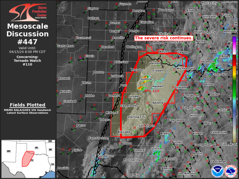
| Mesoscale Discussion 447 |
|
< Previous MD Next MD >
|
|
   Mesoscale Discussion 0447
   NWS Storm Prediction Center Norman OK
   0632 PM CDT Mon Apr 15 2024

   Areas affected...parts of western Texas into far southwest OK

   Concerning...Tornado Watch 110...

   Valid 152332Z - 160100Z

   The severe weather threat for Tornado Watch 110 continues.

   SUMMARY...The severe risk continues. Developing storms across West
   TX will remain capable of all hazards this evening. Broad cloud
   cover may limit the threat farther east until more robust forcing
   arrives from the west.

   DISCUSSION...As of 2315 UTC, regional radar and satellite imagery
   showed storms finally developing near the dryline over
   west/southwest TX. Likely driven by diurnal mixing west of a broad
   cirrus plume, these storms have struggled to maintain intensity over
   the last hour due to remaining MLCINH. Continued heating west of the
   cloud band may allow for additional development into the early
   evening as more intense forcing for ascent from the west. The
   environment remains capped, but moderately unstable with 2000-2500
   J/kg of MLCAPE and dewpoints in the mid to upper 60s F. Strong
   deep-layer shear would support supercellular organization with any
   storms able to be sustained. Given the moderate buoyancy and shear,
   large hail would be likely.

   Hi-res guidance suggests more robust development is possible closer
   to sunset. Low-level flow is also forecast to increase potentially
   increasing the tornado risk with any more sustained supercells that
   become established. While uncertain on how much storm
   development/coverage will occur in the near-term, the environment
   remains favorable for severe weather into this evening.

   ..Lyons.. 04/15/2024

   ...Please see www.spc.noaa.gov for graphic product...

   ATTN...WFO...FWD...OUN...SJT...LUB...MAF...

   LAT...LON   31450127 32240128 32950120 34450037 34679995 34649835
               34479790 33889800 31459964 31090010 31020126 31450127
|
|
Top/All Mesoscale Discussions/Forecast Products/Home
|
|


 @NWSSPC