Note:
The expiration time in the watch graphic is amended if the watch is
replaced, cancelled or extended.
Note:
Note:
The expiration time in the watch graphic is amended if the watch is
replaced, cancelled or extended.
Note: Click for
Watch Status Reports.
SEL7
URGENT - IMMEDIATE BROADCAST REQUESTED
Severe Thunderstorm Watch Number 297
NWS Storm Prediction Center Norman OK
845 PM CDT Thu May 23 2024
The NWS Storm Prediction Center has issued a
* Severe Thunderstorm Watch for portions of
Western Iowa
Extreme northern Kansas
Central and eastern Nebraska
Extreme southeast South Dakota
* Effective this Thursday night and Friday morning from 845 PM
until 400 AM CDT.
* Primary threats include...
Widespread damaging winds and isolated significant gusts to 85
mph likely
Scattered large hail and isolated very large hail events to 2.5
inches in diameter possible
A tornado or two possible
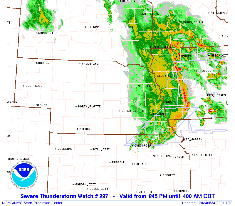
SUMMARY...An intense storm cluster with embedded supercells in
central Nebraska is expected to grow upscale into a larger bowing
line overnight, with an accompanying threat for swaths of severe
wind (60-85 mph). The initial supercells could produce isolated
very large hail up to 2-2.5 inches in diameter, and a tornado or two
will be possible with embedded circulations.
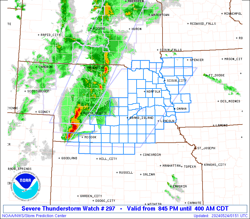
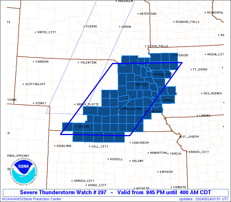
The severe thunderstorm watch area is approximately along and 100
statute miles east and west of a line from 35 miles north northwest
of Sioux City IA to 60 miles east southeast of Mccook NE. For a
complete depiction of the watch see the associated watch outline
update (WOUS64 KWNS WOU7).
PRECAUTIONARY/PREPAREDNESS ACTIONS...
REMEMBER...A Severe Thunderstorm Watch means conditions are
favorable for severe thunderstorms in and close to the watch area.
Persons in these areas should be on the lookout for threatening
weather conditions and listen for later statements and possible
warnings. Severe thunderstorms can and occasionally do produce
tornadoes.
&&
OTHER WATCH INFORMATION...CONTINUE...WW 294...WW 295...WW 296...
AVIATION...A few severe thunderstorms with hail surface and aloft to
2.5 inches. Extreme turbulence and surface wind gusts to 75 knots. A
few cumulonimbi with maximum tops to 550. Mean storm motion vector
25040.
...Thompson

   SEL7

   URGENT - IMMEDIATE BROADCAST REQUESTED
   Severe Thunderstorm Watch Number 297
   NWS Storm Prediction Center Norman OK
   845 PM CDT Thu May 23 2024

   The NWS Storm Prediction Center has issued a

   * Severe Thunderstorm Watch for portions of
     Western Iowa
     Extreme northern Kansas
     Central and eastern Nebraska
     Extreme southeast South Dakota

   * Effective this Thursday night and Friday morning from 845 PM
     until 400 AM CDT.

   * Primary threats include...
     Widespread damaging winds and isolated significant gusts to 85
       mph likely
     Scattered large hail and isolated very large hail events to 2.5
       inches in diameter possible
     A tornado or two possible

   SUMMARY...An intense storm cluster with embedded supercells in
   central Nebraska is expected to grow upscale into a larger bowing
   line overnight, with an accompanying threat for swaths of severe
   wind (60-85 mph).  The initial supercells could produce isolated
   very large hail up to 2-2.5 inches in diameter, and a tornado or two
   will be possible with embedded circulations.

   The severe thunderstorm watch area is approximately along and 100
   statute miles east and west of a line from 35 miles north northwest
   of Sioux City IA to 60 miles east southeast of Mccook NE. For a
   complete depiction of the watch see the associated watch outline
   update (WOUS64 KWNS WOU7).

   PRECAUTIONARY/PREPAREDNESS ACTIONS...

   REMEMBER...A Severe Thunderstorm Watch means conditions are
   favorable for severe thunderstorms in and close to the watch area.
   Persons in these areas should be on the lookout for threatening
   weather conditions and listen for later statements and possible
   warnings. Severe thunderstorms can and occasionally do produce
   tornadoes.

   &&

   OTHER WATCH INFORMATION...CONTINUE...WW 294...WW 295...WW 296...

   AVIATION...A few severe thunderstorms with hail surface and aloft to
   2.5 inches. Extreme turbulence and surface wind gusts to 75 knots. A
   few cumulonimbi with maximum tops to 550. Mean storm motion vector
   25040.

   ...Thompson
 Note:
The Aviation Watch (SAW) product is an approximation to the watch area.
The actual watch is depicted by the shaded areas.
Note:
The Aviation Watch (SAW) product is an approximation to the watch area.
The actual watch is depicted by the shaded areas.
   SAW7
   WW 297 SEVERE TSTM IA KS NE SD 240145Z - 240900Z
   AXIS..100 STATUTE MILES EAST AND WEST OF LINE..
   35NNW SUX/SIOUX CITY IA/ - 60ESE MCK/MCCOOK NE/
   ..AVIATION COORDS.. 85NM E/W /47S FSD - 48NE HLC/
   HAIL SURFACE AND ALOFT..2.5 INCHES. WIND GUSTS..75 KNOTS.
   MAX TOPS TO 550. MEAN STORM MOTION VECTOR 25040.

   LAT...LON 42859467 39849765 39840142 42859862

   THIS IS AN APPROXIMATION TO THE WATCH AREA.  FOR A
   COMPLETE DEPICTION OF THE WATCH SEE WOUS64 KWNS
   FOR WOU7.
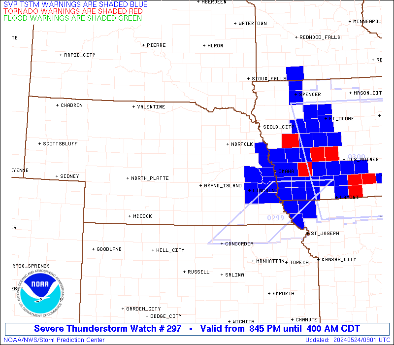
Watch 297 Status Report Messages:
STATUS REPORT #7 ON WW 297
VALID 240840Z - 240940Z
SEVERE WEATHER THREAT CONTINUES RIGHT OF A LINE FROM 10 WSW DNS
TO 35 NW SLB.
..GOSS..05/24/24
ATTN...WFO...FSD...OAX...GLD...GID...
&&
STATUS REPORT FOR WS 297
SEVERE WEATHER THREAT CONTINUES FOR THE FOLLOWING AREAS
IAC021-035-041-093-141-155-165-240940-
IA
. IOWA COUNTIES INCLUDED ARE
BUENA VISTA CHEROKEE CLAY
IDA O'BRIEN POTTAWATTAMIE
SHELBY
$$
THE WATCH STATUS MESSAGE IS FOR GUIDANCE PURPOSES ONLY. PLEASE
REFER TO WATCH COUNTY NOTIFICATION STATEMENTS FOR OFFICIAL
INFORMATION ON COUNTIES...INDEPENDENT CITIES AND MARINE ZONES
CLEARED FROM SEVERE THUNDERSTORM AND TORNADO WATCHES.
$$
STATUS REPORT #6 ON WW 297
VALID 240740Z - 240840Z
SEVERE WEATHER THREAT CONTINUES RIGHT OF A LINE FROM 55 WNW CNK
TO 20 SW LNK TO 35 NNE SUX.
..GOSS..05/24/24
ATTN...WFO...FSD...OAX...GLD...GID...
&&
STATUS REPORT FOR WS 297
SEVERE WEATHER THREAT CONTINUES FOR THE FOLLOWING AREAS
IAC021-035-041-085-093-133-141-149-155-165-167-193-240840-
IA
. IOWA COUNTIES INCLUDED ARE
BUENA VISTA CHEROKEE CLAY
HARRISON IDA MONONA
O'BRIEN PLYMOUTH POTTAWATTAMIE
SHELBY SIOUX WOODBURY
$$
KSC089-240840-
KS
. KANSAS COUNTIES INCLUDED ARE
JEWELL
$$
NEC021-025-053-055-095-109-129-151-153-155-159-169-177-240840-
NE
. NEBRASKA COUNTIES INCLUDED ARE
BURT CASS DODGE
DOUGLAS JEFFERSON LANCASTER
NUCKOLLS SALINE SARPY
SAUNDERS SEWARD THAYER
WASHINGTON
$$
THE WATCH STATUS MESSAGE IS FOR GUIDANCE PURPOSES ONLY. PLEASE
REFER TO WATCH COUNTY NOTIFICATION STATEMENTS FOR OFFICIAL
INFORMATION ON COUNTIES...INDEPENDENT CITIES AND MARINE ZONES
CLEARED FROM SEVERE THUNDERSTORM AND TORNADO WATCHES.
$$
STATUS REPORT #5 ON WW 297
VALID 240635Z - 240740Z
SEVERE WEATHER THREAT CONTINUES RIGHT OF A LINE FROM 25 ENE HLC
TO 15 SSE HSI TO 30 ESE GRI TO 15 W OLU TO 5 W OFK TO 30 NNE OFK
TO 15 WSW FSD.
..MOORE..05/24/24
ATTN...WFO...FSD...OAX...GLD...GID...
&&
STATUS REPORT FOR WS 297
SEVERE WEATHER THREAT CONTINUES FOR THE FOLLOWING AREAS
IAC021-035-041-085-093-133-141-149-155-165-167-193-240740-
IA
. IOWA COUNTIES INCLUDED ARE
BUENA VISTA CHEROKEE CLAY
HARRISON IDA MONONA
O'BRIEN PLYMOUTH POTTAWATTAMIE
SHELBY SIOUX WOODBURY
$$
KSC089-183-240740-
KS
. KANSAS COUNTIES INCLUDED ARE
JEWELL SMITH
$$
NEC021-023-025-035-037-039-043-051-053-055-059-095-109-129-141-
143-151-153-155-159-167-169-173-177-179-181-185-240740-
NE
. NEBRASKA COUNTIES INCLUDED ARE
BURT BUTLER CASS
CLAY COLFAX CUMING
DAKOTA DIXON DODGE
DOUGLAS FILLMORE JEFFERSON
LANCASTER NUCKOLLS PLATTE
POLK SALINE SARPY
SAUNDERS SEWARD STANTON
THAYER THURSTON WASHINGTON
WAYNE WEBSTER YORK
$$
SDC027-127-240740-
SD
. SOUTH DAKOTA COUNTIES INCLUDED ARE
CLAY UNION
$$
THE WATCH STATUS MESSAGE IS FOR GUIDANCE PURPOSES ONLY. PLEASE
REFER TO WATCH COUNTY NOTIFICATION STATEMENTS FOR OFFICIAL
INFORMATION ON COUNTIES...INDEPENDENT CITIES AND MARINE ZONES
CLEARED FROM SEVERE THUNDERSTORM AND TORNADO WATCHES.
$$
STATUS REPORT #4 ON WW 297
VALID 240535Z - 240640Z
SEVERE WEATHER THREAT CONTINUES RIGHT OF A LINE FROM 10 WSW HLC
TO 20 SSE EAR TO 20 NNE EAR TO 45 WSW OFK TO 35 SSW YKN TO 30 N
YKN.
..MOORE..05/24/24
ATTN...WFO...FSD...OAX...GLD...GID...
&&
STATUS REPORT FOR WS 297
SEVERE WEATHER THREAT CONTINUES FOR THE FOLLOWING AREAS
IAC021-035-041-085-093-133-141-149-155-165-167-193-240640-
IA
. IOWA COUNTIES INCLUDED ARE
BUENA VISTA CHEROKEE CLAY
HARRISON IDA MONONA
O'BRIEN PLYMOUTH POTTAWATTAMIE
SHELBY SIOUX WOODBURY
$$
KSC089-147-183-240640-
KS
. KANSAS COUNTIES INCLUDED ARE
JEWELL PHILLIPS SMITH
$$
NEC001-011-021-023-025-027-035-037-039-043-051-053-055-059-061-
079-081-093-095-109-119-121-125-129-139-141-143-151-153-155-159-
167-169-173-177-179-181-185-240640-
NE
. NEBRASKA COUNTIES INCLUDED ARE
ADAMS BOONE BURT
BUTLER CASS CEDAR
CLAY COLFAX CUMING
DAKOTA DIXON DODGE
DOUGLAS FILLMORE FRANKLIN
HALL HAMILTON HOWARD
JEFFERSON LANCASTER MADISON
MERRICK NANCE NUCKOLLS
PIERCE PLATTE POLK
SALINE SARPY SAUNDERS
SEWARD STANTON THAYER
THURSTON WASHINGTON WAYNE
WEBSTER YORK
$$
SDC027-127-240640-
SD
. SOUTH DAKOTA COUNTIES INCLUDED ARE
CLAY UNION
$$
THE WATCH STATUS MESSAGE IS FOR GUIDANCE PURPOSES ONLY. PLEASE
REFER TO WATCH COUNTY NOTIFICATION STATEMENTS FOR OFFICIAL
INFORMATION ON COUNTIES...INDEPENDENT CITIES AND MARINE ZONES
CLEARED FROM SEVERE THUNDERSTORM AND TORNADO WATCHES.
$$
STATUS REPORT #3 ON WW 297
VALID 240435Z - 240540Z
SEVERE WEATHER THREAT CONTINUES RIGHT OF A LINE FROM 30 W HLC TO
45 E MCK TO 20 SSW BBW TO 30 NNW YKN.
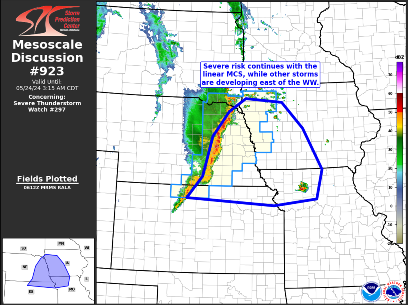
FOR ADDITIONAL INFORMATION SEE MESOSCALE DISCUSSION 921
..MOORE..05/24/24
ATTN...WFO...FSD...OAX...GLD...GID...
&&
STATUS REPORT FOR WS 297
SEVERE WEATHER THREAT CONTINUES FOR THE FOLLOWING AREAS
IAC021-035-041-085-093-133-141-149-155-165-167-193-240540-
IA
. IOWA COUNTIES INCLUDED ARE
BUENA VISTA CHEROKEE CLAY
HARRISON IDA MONONA
O'BRIEN PLYMOUTH POTTAWATTAMIE
SHELBY SIOUX WOODBURY
$$
KSC089-137-147-183-240540-
KS
. KANSAS COUNTIES INCLUDED ARE
JEWELL NORTON PHILLIPS
SMITH
$$
NEC001-003-011-019-021-023-025-027-035-037-039-043-047-051-053-
055-059-061-077-079-081-083-093-095-099-107-109-119-121-125-129-
137-139-141-143-151-153-155-159-163-167-169-173-175-177-179-181-
185-240540-
NE
. NEBRASKA COUNTIES INCLUDED ARE
ADAMS ANTELOPE BOONE
BUFFALO BURT BUTLER
CASS CEDAR CLAY
COLFAX CUMING DAKOTA
DAWSON DIXON DODGE
DOUGLAS FILLMORE FRANKLIN
GREELEY HALL HAMILTON
HARLAN HOWARD JEFFERSON
KEARNEY KNOX LANCASTER
MADISON MERRICK NANCE
NUCKOLLS PHELPS PIERCE
PLATTE POLK SALINE
SARPY SAUNDERS SEWARD
SHERMAN STANTON THAYER
THURSTON VALLEY WASHINGTON
WAYNE WEBSTER YORK
$$
SDC009-027-127-135-240540-
SD
. SOUTH DAKOTA COUNTIES INCLUDED ARE
BON HOMME CLAY UNION
YANKTON
$$
THE WATCH STATUS MESSAGE IS FOR GUIDANCE PURPOSES ONLY. PLEASE
REFER TO WATCH COUNTY NOTIFICATION STATEMENTS FOR OFFICIAL
INFORMATION ON COUNTIES...INDEPENDENT CITIES AND MARINE ZONES
CLEARED FROM SEVERE THUNDERSTORM AND TORNADO WATCHES.
$$
STATUS REPORT #2 ON WW 297
VALID 240340Z - 240440Z
SEVERE WEATHER THREAT CONTINUES RIGHT OF A LINE FROM 40 E GLD TO
15 ESE MCK TO 25 NNW BBW.
..MOORE..05/24/24
ATTN...WFO...FSD...OAX...GLD...GID...
&&
STATUS REPORT FOR WS 297
SEVERE WEATHER THREAT CONTINUES FOR THE FOLLOWING AREAS
IAC021-035-041-085-093-133-141-149-155-165-167-193-240440-
IA
. IOWA COUNTIES INCLUDED ARE
BUENA VISTA CHEROKEE CLAY
HARRISON IDA MONONA
O'BRIEN PLYMOUTH POTTAWATTAMIE
SHELBY SIOUX WOODBURY
$$
KSC039-089-137-147-183-240440-
KS
. KANSAS COUNTIES INCLUDED ARE
DECATUR JEWELL NORTON
PHILLIPS SMITH
$$
NEC001-003-011-019-021-023-025-027-035-037-039-043-047-051-053-
055-059-061-065-073-077-079-081-083-093-095-099-107-109-119-121-
125-129-137-139-141-143-151-153-155-159-163-167-169-173-175-177-
179-181-185-240440-
NE
. NEBRASKA COUNTIES INCLUDED ARE
ADAMS ANTELOPE BOONE
BUFFALO BURT BUTLER
CASS CEDAR CLAY
COLFAX CUMING DAKOTA
DAWSON DIXON DODGE
DOUGLAS FILLMORE FRANKLIN
FURNAS GOSPER GREELEY
HALL HAMILTON HARLAN
HOWARD JEFFERSON KEARNEY
KNOX LANCASTER MADISON
MERRICK NANCE NUCKOLLS
PHELPS PIERCE PLATTE
POLK SALINE SARPY
SAUNDERS SEWARD SHERMAN
STANTON THAYER THURSTON
VALLEY WASHINGTON WAYNE
WEBSTER YORK
$$
SDC009-027-127-135-240440-
SD
. SOUTH DAKOTA COUNTIES INCLUDED ARE
BON HOMME CLAY UNION
YANKTON
$$
THE WATCH STATUS MESSAGE IS FOR GUIDANCE PURPOSES ONLY. PLEASE
REFER TO WATCH COUNTY NOTIFICATION STATEMENTS FOR OFFICIAL
INFORMATION ON COUNTIES...INDEPENDENT CITIES AND MARINE ZONES
CLEARED FROM SEVERE THUNDERSTORM AND TORNADO WATCHES.
$$
STATUS REPORT #1 ON WW 297
VALID 240240Z - 240340Z
THE SEVERE WEATHER THREAT CONTINUES ACROSS THE ENTIRE WATCH AREA.
..MOORE..05/24/24
ATTN...WFO...FSD...OAX...GLD...GID...
&&
STATUS REPORT FOR WS 297
SEVERE WEATHER THREAT CONTINUES FOR THE FOLLOWING AREAS
IAC021-035-041-085-093-133-141-149-155-165-167-193-240340-
IA
. IOWA COUNTIES INCLUDED ARE
BUENA VISTA CHEROKEE CLAY
HARRISON IDA MONONA
O'BRIEN PLYMOUTH POTTAWATTAMIE
SHELBY SIOUX WOODBURY
$$
KSC039-089-137-147-183-240340-
KS
. KANSAS COUNTIES INCLUDED ARE
DECATUR JEWELL NORTON
PHILLIPS SMITH
$$
NEC001-003-011-019-021-023-025-027-035-037-039-043-047-051-053-
055-059-061-065-073-077-079-081-083-087-093-095-099-107-109-119-
121-125-129-137-139-141-143-145-151-153-155-159-163-167-169-173-
175-177-179-181-185-240340-
NE
. NEBRASKA COUNTIES INCLUDED ARE
ADAMS ANTELOPE BOONE
BUFFALO BURT BUTLER
CASS CEDAR CLAY
COLFAX CUMING DAKOTA
DAWSON DIXON DODGE
DOUGLAS FILLMORE FRANKLIN
FURNAS GOSPER GREELEY
HALL HAMILTON HARLAN
HITCHCOCK HOWARD JEFFERSON
KEARNEY KNOX LANCASTER
MADISON MERRICK NANCE
NUCKOLLS PHELPS PIERCE
PLATTE POLK RED WILLOW
SALINE SARPY SAUNDERS
SEWARD SHERMAN STANTON
THAYER THURSTON VALLEY
WASHINGTON WAYNE WEBSTER
YORK
$$
SDC009-027-127-135-240340-
SD
. SOUTH DAKOTA COUNTIES INCLUDED ARE
BON HOMME CLAY UNION
YANKTON
$$
THE WATCH STATUS MESSAGE IS FOR GUIDANCE PURPOSES ONLY. PLEASE
REFER TO WATCH COUNTY NOTIFICATION STATEMENTS FOR OFFICIAL
INFORMATION ON COUNTIES...INDEPENDENT CITIES AND MARINE ZONES
CLEARED FROM SEVERE THUNDERSTORM AND TORNADO WATCHES.
$$
Note:
Click for Complete Product Text.
Tornadoes
Probability of 2 or more tornadoes
|
Low (20%)
|
Probability of 1 or more strong (EF2-EF5) tornadoes
|
Low (5%)
|
Wind
Probability of 10 or more severe wind events
|
High (80%)
|
Probability of 1 or more wind events > 65 knots
|
High (70%)
|
Hail
Probability of 10 or more severe hail events
|
Mod (50%)
|
Probability of 1 or more hailstones > 2 inches
|
Mod (40%)
|
Combined Severe Hail/Wind
Probability of 6 or more combined severe hail/wind events
|
High (>95%)
|
For each watch, probabilities for particular events inside the watch
(listed above in each table) are determined by the issuing forecaster.
The "Low" category contains probability values ranging from less than 2%
to 20% (EF2-EF5 tornadoes), less than 5% to 20% (all other probabilities),
"Moderate" from 30% to 60%, and "High" from 70% to greater than 95%.
High values are bolded and lighter in color to provide awareness of
an increased threat for a particular event.


 @NWSSPC