Note:
The expiration time in the watch graphic is amended if the watch is
replaced, cancelled or extended.
Note:
Note:
The expiration time in the watch graphic is amended if the watch is
replaced, cancelled or extended.
Note: Click for
Watch Status Reports.
SEL5
URGENT - IMMEDIATE BROADCAST REQUESTED
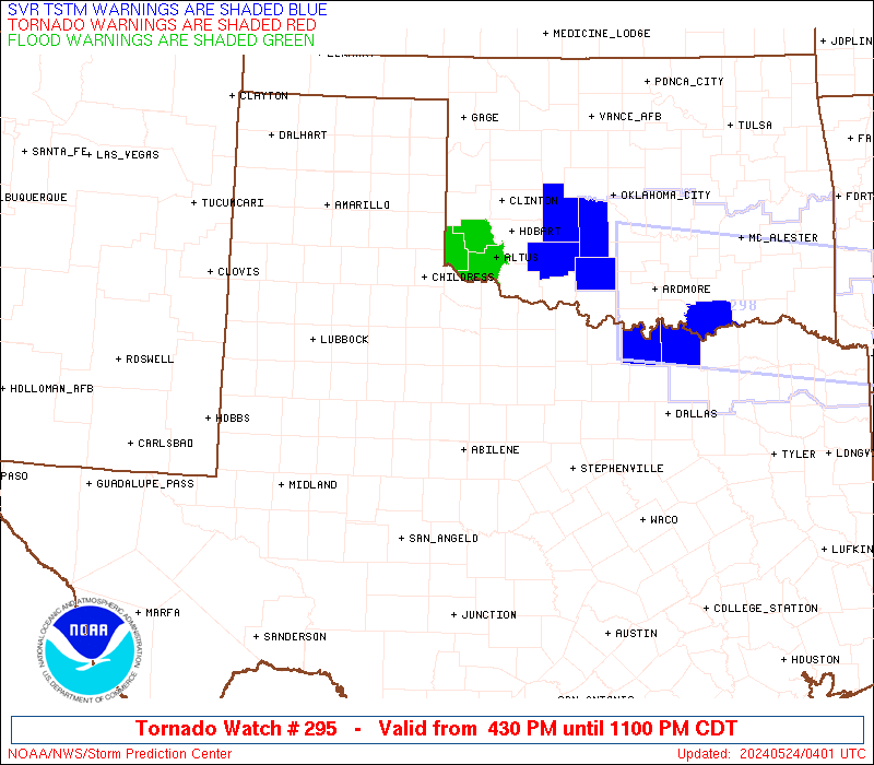
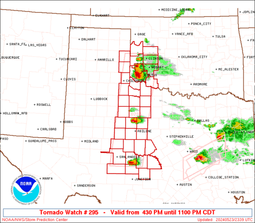
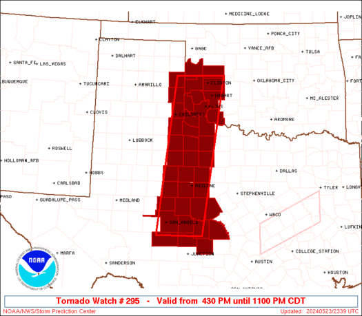
Tornado Watch Number 295
NWS Storm Prediction Center Norman OK
430 PM CDT Thu May 23 2024
The NWS Storm Prediction Center has issued a
* Tornado Watch for portions of
Southwest Oklahoma
The Edwards Plateau into northwest Texas
* Effective this Thursday afternoon and evening from 430 PM until
1100 PM CDT.
* Primary threats include...
A couple tornadoes possible
Scattered large hail and isolated very large hail events to 3.5
inches in diameter possible
Isolated damaging wind gusts to 70 mph possible
SUMMARY...A few supercells are expected to form late this afternoon
along the dryline, and storms will move slowly eastward through late
evening. The storm environment favors isolated very large hail (up
to 3.5 inches in diameter) as the main threat, though a couple of
tornadoes will also be possible.
The tornado watch area is approximately along and 45 statute miles
east and west of a line from 20 miles northwest of Clinton OK to 35
miles southeast of San Angelo TX. For a complete depiction of the
watch see the associated watch outline update (WOUS64 KWNS WOU5).
PRECAUTIONARY/PREPAREDNESS ACTIONS...
REMEMBER...A Tornado Watch means conditions are favorable for
tornadoes and severe thunderstorms in and close to the watch
area. Persons in these areas should be on the lookout for
threatening weather conditions and listen for later statements
and possible warnings.
&&
OTHER WATCH INFORMATION...CONTINUE...WW 293...WW 294...
AVIATION...Tornadoes and a few severe thunderstorms with hail
surface and aloft to 3.5 inches. Extreme turbulence and surface wind
gusts to 60 knots. A few cumulonimbi with maximum tops to 600. Mean
storm motion vector 26020.
...Thompson
   SEL5

   URGENT - IMMEDIATE BROADCAST REQUESTED
   Tornado Watch Number 295
   NWS Storm Prediction Center Norman OK
   430 PM CDT Thu May 23 2024

   The NWS Storm Prediction Center has issued a

   * Tornado Watch for portions of
     Southwest Oklahoma
     The Edwards Plateau into northwest Texas

   * Effective this Thursday afternoon and evening from 430 PM until
     1100 PM CDT.

   * Primary threats include...
     A couple tornadoes possible
     Scattered large hail and isolated very large hail events to 3.5
       inches in diameter possible
     Isolated damaging wind gusts to 70 mph possible

   SUMMARY...A few supercells are expected to form late this afternoon
   along the dryline, and storms will move slowly eastward through late
   evening.  The storm environment favors isolated very large hail (up
   to 3.5 inches in diameter) as the main threat, though a couple of
   tornadoes will also be possible.

   The tornado watch area is approximately along and 45 statute miles
   east and west of a line from 20 miles northwest of Clinton OK to 35
   miles southeast of San Angelo TX. For a complete depiction of the
   watch see the associated watch outline update (WOUS64 KWNS WOU5).

   PRECAUTIONARY/PREPAREDNESS ACTIONS...

   REMEMBER...A Tornado Watch means conditions are favorable for
   tornadoes and severe thunderstorms in and close to the watch
   area. Persons in these areas should be on the lookout for
   threatening weather conditions and listen for later statements
   and possible warnings.

   &&

   OTHER WATCH INFORMATION...CONTINUE...WW 293...WW 294...

   AVIATION...Tornadoes and a few severe thunderstorms with hail
   surface and aloft to 3.5 inches. Extreme turbulence and surface wind
   gusts to 60 knots. A few cumulonimbi with maximum tops to 600. Mean
   storm motion vector 26020.

   ...Thompson
 Note:
The Aviation Watch (SAW) product is an approximation to the watch area.
The actual watch is depicted by the shaded areas.
Note:
The Aviation Watch (SAW) product is an approximation to the watch area.
The actual watch is depicted by the shaded areas.
   SAW5
   WW 295 TORNADO OK TX 232130Z - 240400Z
   AXIS..45 STATUTE MILES EAST AND WEST OF LINE..
   20NW CSM/CLINTON OK/ - 35SE SJT/SAN ANGELO TX/
   ..AVIATION COORDS.. 40NM E/W /53SSE MMB - 28NNW JCT/
   HAIL SURFACE AND ALOFT..3.5 INCHES. WIND GUSTS..60 KNOTS.
   MAX TOPS TO 600. MEAN STORM MOTION VECTOR 26020.

   LAT...LON 35539865 31019932 31010084 35530025

   THIS IS AN APPROXIMATION TO THE WATCH AREA.  FOR A
   COMPLETE DEPICTION OF THE WATCH SEE WOUS64 KWNS
   FOR WOU5.
Watch 295 Status Report Messages:
STATUS REPORT #5 ON WW 295

VALID 240235Z - 240340Z

SEVERE WEATHER THREAT CONTINUES RIGHT OF A LINE FROM 25 SW SPS TO
40 SSW LTS TO 20 SSW CSM TO 15 NNW CHK.

..MOORE..05/24/24

ATTN...WFO...OUN...SJT...LUB...AMA...

&&

STATUS REPORT FOR WT 295

SEVERE WEATHER THREAT CONTINUES FOR THE FOLLOWING AREAS

OKC031-033-065-075-141-240340-

OK
.    OKLAHOMA COUNTIES INCLUDED ARE

COMANCHE	     COTTON		 JACKSON
KIOWA		     TILLMAN
$$


TXC487-240340-

TX
.    TEXAS COUNTIES INCLUDED ARE

WILBARGER
$$


THE WATCH STATUS MESSAGE IS FOR GUIDANCE PURPOSES ONLY.  PLEASE
REFER TO WATCH COUNTY NOTIFICATION STATEMENTS FOR OFFICIAL
INFORMATION ON COUNTIES...INDEPENDENT CITIES AND MARINE ZONES
CLEARED FROM SEVERE THUNDERSTORM AND TORNADO WATCHES.
$$

STATUS REPORT #4 ON WW 295

VALID 240155Z - 240240Z

SEVERE WEATHER THREAT CONTINUES RIGHT OF A LINE FROM 25 W JCT TO
50 SW BWD TO 30 N BWD TO 40 SW SPS TO 20 ENE CDS TO 45 W CSM TO
60 NW CSM.

..MOORE..05/24/24

ATTN...WFO...OUN...SJT...LUB...AMA...

&&

STATUS REPORT FOR WT 295

SEVERE WEATHER THREAT CONTINUES FOR THE FOLLOWING AREAS

OKC009-039-055-057-065-075-129-141-149-240240-

OK
.    OKLAHOMA COUNTIES INCLUDED ARE

BECKHAM 	     CUSTER		 GREER
HARMON		     JACKSON		 KIOWA
ROGER MILLS	     TILLMAN		 WASHITA
$$


TXC049-307-319-411-487-240240-

TX
.    TEXAS COUNTIES INCLUDED ARE

BROWN		     MCCULLOCH		 MASON
SAN SABA	     WILBARGER
$$


THE WATCH STATUS MESSAGE IS FOR GUIDANCE PURPOSES ONLY.  PLEASE
REFER TO WATCH COUNTY NOTIFICATION STATEMENTS FOR OFFICIAL
INFORMATION ON COUNTIES...INDEPENDENT CITIES AND MARINE ZONES
CLEARED FROM SEVERE THUNDERSTORM AND TORNADO WATCHES.
$$

STATUS REPORT #3 ON WW 295

VALID 240050Z - 240140Z

THE SEVERE WEATHER THREAT CONTINUES ACROSS THE ENTIRE WATCH AREA.

FOR ADDITIONAL INFORMATION SEE MESOSCALE DISCUSSION 918

..DEAN..05/24/24

ATTN...WFO...OUN...SJT...LUB...AMA...

&&

STATUS REPORT FOR WT 295

SEVERE WEATHER THREAT CONTINUES FOR THE FOLLOWING AREAS

OKC009-039-055-057-065-075-129-141-149-240140-

OK
.    OKLAHOMA COUNTIES INCLUDED ARE

BECKHAM 	     CUSTER		 GREER
HARMON		     JACKSON		 KIOWA
ROGER MILLS	     TILLMAN		 WASHITA
$$


TXC023-049-059-075-081-083-095-101-151-155-197-207-253-269-275-
307-319-327-353-399-411-413-417-433-441-447-451-487-240140-

TX
.    TEXAS COUNTIES INCLUDED ARE

BAYLOR		     BROWN		 CALLAHAN
CHILDRESS	     COKE		 COLEMAN
CONCHO		     COTTLE		 FISHER
FOARD		     HARDEMAN		 HASKELL
JONES		     KING		 KNOX
MCCULLOCH	     MASON		 MENARD
NOLAN		     RUNNELS		 SAN SABA
SCHLEICHER	     SHACKELFORD	 STONEWALL
TAYLOR		     THROCKMORTON	 TOM GREEN
WILBARGER
$$


THE WATCH STATUS MESSAGE IS FOR GUIDANCE PURPOSES ONLY.  PLEASE
REFER TO WATCH COUNTY NOTIFICATION STATEMENTS FOR OFFICIAL
INFORMATION ON COUNTIES...INDEPENDENT CITIES AND MARINE ZONES
CLEARED FROM SEVERE THUNDERSTORM AND TORNADO WATCHES.
$$

STATUS REPORT #2 ON WW 295

VALID 232350Z - 240040Z

THE SEVERE WEATHER THREAT CONTINUES ACROSS THE ENTIRE WATCH AREA.

FOR ADDITIONAL INFORMATION SEE MESOSCALE DISCUSSION 916

..DEAN..05/23/24

ATTN...WFO...OUN...SJT...LUB...AMA...

&&

STATUS REPORT FOR WT 295

SEVERE WEATHER THREAT CONTINUES FOR THE FOLLOWING AREAS

OKC009-039-055-057-065-075-129-141-149-240040-

OK
.    OKLAHOMA COUNTIES INCLUDED ARE

BECKHAM 	     CUSTER		 GREER
HARMON		     JACKSON		 KIOWA
ROGER MILLS	     TILLMAN		 WASHITA
$$


TXC023-049-059-075-081-083-087-095-101-151-155-197-207-253-269-
275-307-319-327-353-399-411-413-417-433-441-447-451-483-487-
240040-

TX
.    TEXAS COUNTIES INCLUDED ARE

BAYLOR		     BROWN		 CALLAHAN
CHILDRESS	     COKE		 COLEMAN
COLLINGSWORTH	     CONCHO		 COTTLE
FISHER		     FOARD		 HARDEMAN
HASKELL 	     JONES		 KING
KNOX		     MCCULLOCH		 MASON
MENARD		     NOLAN		 RUNNELS
SAN SABA	     SCHLEICHER 	 SHACKELFORD
STONEWALL	     TAYLOR		 THROCKMORTON
TOM GREEN	     WHEELER		 WILBARGER
$$


THE WATCH STATUS MESSAGE IS FOR GUIDANCE PURPOSES ONLY.  PLEASE
REFER TO WATCH COUNTY NOTIFICATION STATEMENTS FOR OFFICIAL
INFORMATION ON COUNTIES...INDEPENDENT CITIES AND MARINE ZONES
CLEARED FROM SEVERE THUNDERSTORM AND TORNADO WATCHES.
$$

STATUS REPORT #1 ON WW 295

VALID 232240Z - 232340Z

THE SEVERE WEATHER THREAT CONTINUES ACROSS THE ENTIRE WATCH AREA.

..DEAN..05/23/24

ATTN...WFO...OUN...SJT...LUB...AMA...

&&

STATUS REPORT FOR WT 295

SEVERE WEATHER THREAT CONTINUES FOR THE FOLLOWING AREAS

OKC009-039-055-057-065-075-129-141-149-232340-

OK
.    OKLAHOMA COUNTIES INCLUDED ARE

BECKHAM 	     CUSTER		 GREER
HARMON		     JACKSON		 KIOWA
ROGER MILLS	     TILLMAN		 WASHITA
$$


TXC023-049-059-075-081-083-087-095-101-151-155-197-207-253-269-
275-307-319-327-353-399-411-413-417-433-441-447-451-483-487-
232340-

TX
.    TEXAS COUNTIES INCLUDED ARE

BAYLOR		     BROWN		 CALLAHAN
CHILDRESS	     COKE		 COLEMAN
COLLINGSWORTH	     CONCHO		 COTTLE
FISHER		     FOARD		 HARDEMAN
HASKELL 	     JONES		 KING
KNOX		     MCCULLOCH		 MASON
MENARD		     NOLAN		 RUNNELS
SAN SABA	     SCHLEICHER 	 SHACKELFORD
STONEWALL	     TAYLOR		 THROCKMORTON
TOM GREEN	     WHEELER		 WILBARGER
$$


THE WATCH STATUS MESSAGE IS FOR GUIDANCE PURPOSES ONLY.  PLEASE
REFER TO WATCH COUNTY NOTIFICATION STATEMENTS FOR OFFICIAL
INFORMATION ON COUNTIES...INDEPENDENT CITIES AND MARINE ZONES
CLEARED FROM SEVERE THUNDERSTORM AND TORNADO WATCHES.
$$
Note:
Click for Complete Product Text.
Tornadoes
Probability of 2 or more tornadoes
|
Mod (40%)
|
Probability of 1 or more strong (EF2-EF5) tornadoes
|
Low (20%)
|
Wind
Probability of 10 or more severe wind events
|
Mod (30%)
|
Probability of 1 or more wind events > 65 knots
|
Low (20%)
|
Hail
Probability of 10 or more severe hail events
|
Mod (50%)
|
Probability of 1 or more hailstones > 2 inches
|
Mod (50%)
|
Combined Severe Hail/Wind
Probability of 6 or more combined severe hail/wind events
|
High (70%)
|
For each watch, probabilities for particular events inside the watch
(listed above in each table) are determined by the issuing forecaster.
The "Low" category contains probability values ranging from less than 2%
to 20% (EF2-EF5 tornadoes), less than 5% to 20% (all other probabilities),
"Moderate" from 30% to 60%, and "High" from 70% to greater than 95%.
High values are bolded and lighter in color to provide awareness of
an increased threat for a particular event.


 @NWSSPC