|
| Mesoscale Discussion 921 |
|
< Previous MD Next MD >
|
|
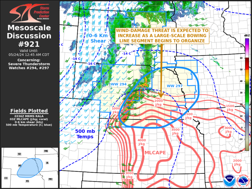
   Mesoscale Discussion 0921
   NWS Storm Prediction Center Norman OK
   1038 PM CDT Thu May 23 2024

   Areas affected...Central and Eastern Nebraska...Far Northern
   Kansas...Western Iowa

   Concerning...Severe Thunderstorm Watch 294...297...

   Valid 240338Z - 240545Z

   The severe weather threat for Severe Thunderstorm Watch 294, 297
   continues.

   SUMMARY...The wind-damage threat will likely increase as a linear
   MCS organizes across central and eastern Nebraska over the next
   couple of hours. The severe threat should eventually affect parts of
   western Iowa, where additional watch issuance may be needed during
   the overnight period.

   DISCUSSION...Mosaic radar imagery currently shows a developing line
   of strong to severe thunderstorms from far northwest Kansas into
   central and northeast Nebraska. This line is forecast to begin to
   accelerate eastward across central and eastern Nebraska over the
   next couple of hours, as a strengthening low-level jet increases
   moisture and instability across the central Plains. As the storms
   move eastward along a west-northwest to east-southeast gradient of
   moderate to strong instability, the MCS is expected to become
   increasingly organized. A wind-damage threat will be possible with
   the stronger parts of the line, and this threat should become more
   widespread as a large-scale bowing line segment organizes. The
   wind-damage threat will affect much of eastern Nebraska late this
   evening, and may affect western Iowa well after midnight.

   ..Broyles.. 05/24/2024

   ...Please see www.spc.noaa.gov for graphic product...

   ATTN...WFO...DMX...EAX...FSD...OAX...TOP...GID...LBF...GLD...

   LAT...LON   39589971 39569779 39859683 40279600 41089500 41769487
               42269499 42739550 42889648 42809785 42359895 41859949
               40990026 40190064 39720029 39589971
|
|
Top/All Mesoscale Discussions/Forecast Products/Home
|
|


 @NWSSPC