|
| Mesoscale Discussion 916 |
|
< Previous MD Next MD >
|
|
Mesoscale Discussion 0916
NWS Storm Prediction Center Norman OK
0600 PM CDT Thu May 23 2024
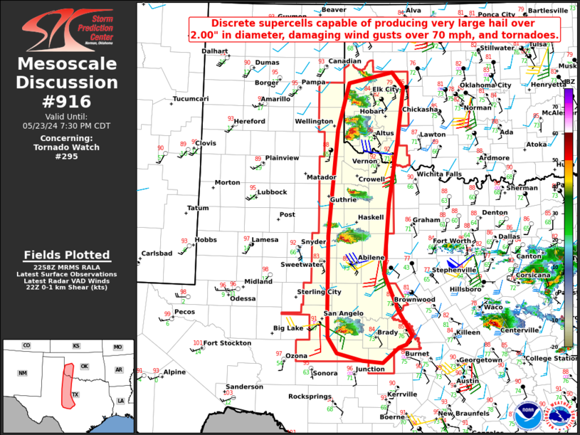
Areas affected...Portions of western/southwestern Oklahoma...western
north Texas...the western Low Rolling Plains...and the Edwards
Plateau
Concerning...Tornado Watch 295...
Valid 232300Z - 240030Z
The severe weather threat for Tornado Watch 295 continues.
SUMMARY...Discrete supercells, moving east off a dryline, from
southwestern OK through the Edwards Plateau of TX remain capable of
producing very large hail over 2.00" in diameter, damaging wind
gusts over 70 mph, and tornadoes.
DISCUSSION...Several discrete supercells have developed early this
evening along a dryline, and should maintain their intensity over
the next several hours. These thunderstorms have developed in an
environment with steep mid-level lapse rates ranging from 7 to 8
C/km south to north respectively. Surface temperatures in the upper
80s to 90s along with dewpoints in the low to mid 70s are yielding a
narrow axis of extreme buoyancy just ahead of the dryline. Further
east, a more stable troposphere is noted via visible satellite
imagery behind several outflow boundaries and convective debris.
Ambient 0-1 km SRH can be estimated via SJT VAD and current
mesoanalysis to be near 100-200 m2/s2. A corridor of stronger SSE
surface flow juxtaposed with the instability axis, a slow increase
in the LLJ through the evening, and enhanced backing near the
dryline circulation across SW OK may lead to locally enhanced low
level shear/a more favorable tornadic environment. In addition, very
large CAPE through the hail growth zone (OUN 20Z observed sounding)
and effective shear > 50 kt will continue to support very large
hail. Localized severe damaging wind gusts will also remain possible
..Barnes.. 05/23/2024
...Please see www.spc.noaa.gov for graphic product...
ATTN...WFO...FWD...OUN...EWX...SJT...LUB...AMA...
LAT...LON 31560032 32920032 34770013 35619988 35799897 35529873
34619885 33489904 32249915 31609887 31159859 30999870
30949885 30689918 30719961 30840012 31120031 31560032
|
|
Top/All Mesoscale Discussions/Forecast Products/Home
|
|


 @NWSSPC