|
| Mesoscale Discussion 918 |
|
< Previous MD Next MD >
|
|
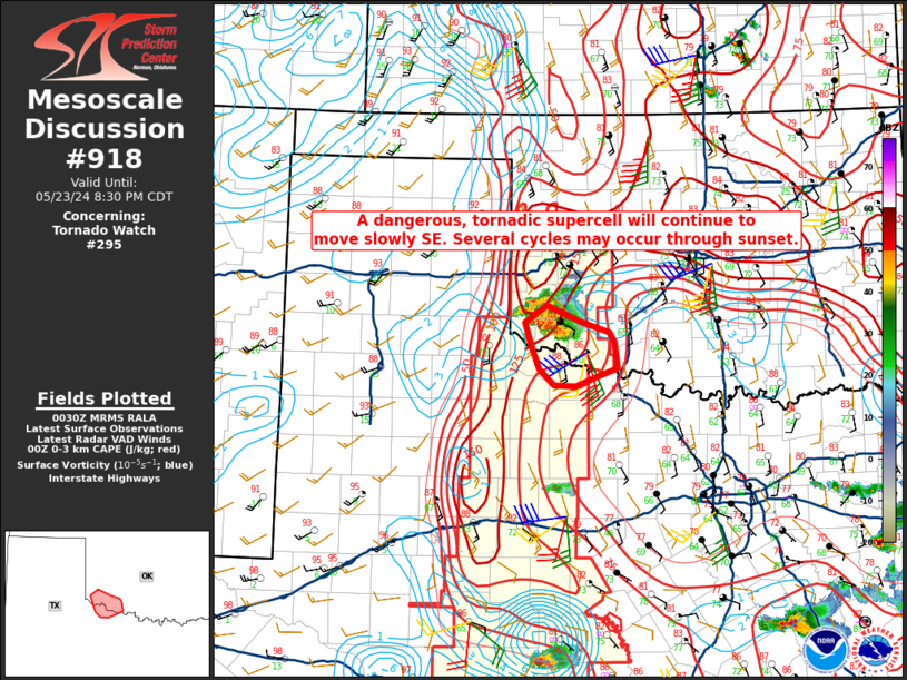
   Mesoscale Discussion 0918
   NWS Storm Prediction Center Norman OK
   0733 PM CDT Thu May 23 2024

   Areas affected...Southwestern Oklahoma

   Concerning...Tornado Watch 295...

   Valid 240033Z - 240130Z

   The severe weather threat for Tornado Watch 295 continues.

   SUMMARY...A dangerous, tornadic supercell is expected to continue
   slowly moving ESE across Jackson County, and as far south as the Red
   River over the next hour.

   DISCUSSION...Recent radar imagery from KFDR indicates VROT has
   increased to 90-105 kt within an ongoing, confirmed tornado located
   just west of Olustee, OK (southwest of Altus). The extremely
   unstable environment downstream of this strong to violent tornado
   will continue to favor tornadogensis, where SSE sustained surface
   winds around 20 to 25 kt will enhance localized surface vorticity.

   ..Barnes.. 05/24/2024

   ...Please see www.spc.noaa.gov for graphic product...

   ATTN...WFO...OUN...

   LAT...LON   34429971 34689979 34889951 34709905 34589867 34469859
               34189856 34069888 33989911 33999941 34169960 34429971
|
|
Top/All Mesoscale Discussions/Forecast Products/Home
|
|


 @NWSSPC